Cape Girardeau, Missouri
| Cape Girardeau, Missouri | |
|---|---|
| City | |
|
Downtown Cape Girardeau | |
| Nickname(s): Cape, The City of Roses, River City | |
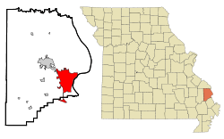 Location of Cape Girardeau within County and State | |
| Coordinates: 37°18′33″N 89°32′47″W / 37.30917°N 89.54639°WCoordinates: 37°18′33″N 89°32′47″W / 37.30917°N 89.54639°W | |
| Country | United States |
| State | Missouri |
| Counties | Cape Girardeau, Scott |
| Founded | 1793 |
| Government | |
| • Type | Mayor-Council |
| • Mayor | Harry E. Rediger (R) |
| Area[1] | |
| • City | 28.49 sq mi (73.79 km2) |
| • Land | 28.43 sq mi (73.63 km2) |
| • Water | 0.06 sq mi (0.16 km2) |
| Elevation | 351 ft (107 m) |
| Population (2010)[2] | |
| • City | 37,941 |
| • Estimate (2014[3]) | 39,167 |
| • Density | 1,334.5/sq mi (515.3/km2) |
| • Metro | 134,051 |
| Time zone | Central (CST) (UTC-6) |
| • Summer (DST) | CDT (UTC-5) |
| ZIP Code | 63701–63703, 63705 |
| Area code(s) | 573 |
| FIPS code | 29-11242[4] |
| GNIS feature ID | 0731549[5] |
| Website | www.cityofcapegirardeau.org |
.JPG)
Cape Girardeau (/ˈkeɪp dʒᵻˈrɑːrdoʊ/, French: Cap-Girardeau [kap ʒiʁaʁdo]; colloquially referred to as "Cape") is a city in Cape Girardeau and Scott counties in the U.S. state of Missouri. It is located approximately 115 miles (185 km) southeast of St. Louis and 175 miles (282 km) north of Memphis. As of the 2010 U.S. Census, the city's population was 37,941, making it the 16th-largest city in Missouri,[6] and the largest city in Southeast Missouri. An emerging college town, it is the home of Southeast Missouri State University.
History
The city is named after Jean Baptiste de Girardot, who established a temporary trading post in the area around 1733. He was a French soldier stationed at Kaskaskia between 1704–1720 in the French colony of La Louisiane. The "Cape" in the city name referred to a rock promontory overlooking the Mississippi River; it was later destroyed by railroad construction.[7] As early as 1765, a bend in the Mississippi River, about 60 miles (97 km) south of the French village of Ste. Genevieve, had been referred to as Cape Girardot or Girardeau.
The settlement of Girardeau is said to date from 1793 when the Spanish government, which had acquired Louisiana in 1764 following the French defeat in the Seven Years' War, granted Louis Lorimier, a French-Canadian, the right to establish a trading post. This gave him trading privileges and a large tract of land surrounding his post. Lorimier was made commandant of the district and prospered from the returns on his land sales and trade with indigenous peoples, such as the Ozark Bluff Dwellers and the Mississippian people.
Also in 1793, Baron Carondelet granted land near Cape Girardeau to the Black Bob Band of the Hathawekela Shawnee, who had migrated from across the Mississippi River. The Band became known as the Cape Girardeau Shawnee. They successfully resisted removal to Indian Territory with the rest of the Shawnee tribe until 1833.[8][9][10]
In 1799, American settlers founded the first English school west of the Mississippi River in Cape Girardeau at a landmark called Mount Tabor, named by the settlers for the Biblical Mount Tabor.[11]
The town of Cape Girardeau was incorporated in 1808, prior to Missouri statehood. It was reincorporated as a city in 1843. The advent of the steamboat in 1835 and related river trade stimulated the development of Cape Girardeau as the biggest port on the Mississippi River between St. Louis, Missouri and Memphis, Tennessee.
During the Civil War, the city was engulfed by the Battle of Cape Girardeau on April 26, 1863. The Union and Confederate armies collided in a fierce, four-hour artillery barrage in which 23 Union and 30 Confederate soldiers were killed.
For years travelers had to use ferries to cross the Mississippi River from Cape Girardeau. In September 1928 a bridge was completed between Missouri and Illinois. Built to accommodate cars, it was 20 feet (6.1 m) wide under standards of the time.[12]
The Old Federal Courthouse, located at Broadway and Fountain Streets and built in the late 1940s, was the subject of a U.S. Supreme Court case when it was being developed. In United States v. Carmack, 329 U.S. 230 (1946), the Court upheld the federal government's authority under the Condemnation Act of 1888 to seize land owned by a state or locality.[13]
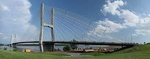
In December 2003, the "Old Bridge" was succeeded by a new four-lane cable-stay bridge crossing the Mississippi River at Cape Girardeau. Its official name is "The Bill Emerson Memorial Bridge.", honoring former U.S. Rep. Bill Emerson (R-Mo.) The two towers of the bridge reach a height of approximately 91 meters. The "Old Bridge" was completed in September 1928 to replace a ferry and was only 20 feet (6.1 m) wide.[12] The "Old Bridge" was demolished after the Emerson Bridge opened.
The City of Cape Girardeau was recognized in January 2008 by First Lady Laura Bush as a Preserve America Community for its work in surveying and protecting historic buildings, as well as .[14]
The city is known to some as "The City of Roses" because of a 9-mile (14 km) stretch of highway that was once lined with dozens of rose bushes. Although there used to be many prominent rose gardens around the community, few of these gardens have been maintained. The city is also known as "Cape Girardeau: Where the River Turns a Thousand Tales," due to the history of the town and the Mississippi River.
Historic landmarks
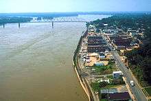
Numerous murals commemorate the city's history. The largest is the Mississippi River Tales Mural, located on the city's downtown floodwall. Covering nearly 18,000 square feet (1,700 m2), it spans the length of the downtown shopping district and features 24 panels. Behind the floodwall lies the Riverfront Park of Cape Girardeau Missouri, where riverboats dock and visitors can view the Mississippi River.
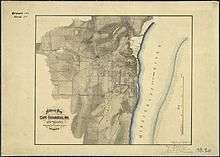
There are 39 historic sites in Cape Girardeau that are listed on the National Register of Historic Places. Of these, eight are historic districts, such as Cape Girardeau Commercial Historic District, which was listed in 2000 and includes multiple contributing properties. The growth of the town can be documented through Sanborn Maps, over 80 of which are available online.[15] Other landmarks include the Fort D Historic Site and the Confederate War Memorial.
Among the city's older cemeteries are Apple Creek Cemetery,[16] Salem Cemetery.[17] and Old Lorimier Cemetery[18]
Geography
Cape Girardeau is located at 37°18′33″N 89°32′47″W / 37.30917°N 89.54639°W (37.309042, -89.546498).[19] According to the United States Census Bureau, the city has a total area of 28.49 square miles (73.79 km2), of which, 28.43 square miles (73.63 km2) is land and 0.06 square miles (0.16 km2) is water.[1] The "cape" that the city is named after no longer exists. A rock which remains from the previously existing cape can be seen on a promontory which overlooks the Mississippi River in Cape Rock Park.
Climate
Cape Girardeau has a humid subtropical climate (Köppen Cfa) with four distinct seasons and is located in USDA Plant Hardiness Zone 6b.[20] Winter typically brings a mix of rain, sleet, and snow, with occasional heavy snowfall and icing. The city has a January daily average of 33.1 °F (0.6 °C) and averages 14 days annually with temperatures staying at or below freezing; the first and last freezes of the season on average fall on October 23 and April 7, respectively.[21] Summer is typically hazy, hot, and humid with a July daily average of 78.6 °F (25.9 °C), and there is an average of 48 days a year with high temperatures at or above 90 °F (32 °C).[21] The average annual precipitation is 46.8 inches (1,190 mm), with the rainiest season being spring.[21] Extremes in temperature range from 107 °F (42 °C), which last occurred on June 29, 2012, down to −18 °F (−28 °C) on January 11, 1977.[21]
| Climate data for Cape Girardeau Regional Airport, Missouri (1981–2010 normals, extremes 1960–present) | |||||||||||||
|---|---|---|---|---|---|---|---|---|---|---|---|---|---|
| Month | Jan | Feb | Mar | Apr | May | Jun | Jul | Aug | Sep | Oct | Nov | Dec | Year |
| Record high °F (°C) | 73 (23) |
79 (26) |
94 (34) |
91 (33) |
97 (36) |
107 (42) |
106 (41) |
105 (41) |
100 (38) |
93 (34) |
82 (28) |
76 (24) |
107 (42) |
| Average high °F (°C) | 42.4 (5.8) |
47.8 (8.8) |
58.2 (14.6) |
68.8 (20.4) |
77.8 (25.4) |
86.3 (30.2) |
89.4 (31.9) |
88.7 (31.5) |
81.3 (27.4) |
70.4 (21.3) |
57.4 (14.1) |
44.9 (7.2) |
67.8 (19.9) |
| Average low °F (°C) | 23.9 (−4.5) |
28.0 (−2.2) |
36.0 (2.2) |
45.5 (7.5) |
55.6 (13.1) |
64.2 (17.9) |
67.8 (19.9) |
65.4 (18.6) |
56.3 (13.5) |
45.1 (7.3) |
36.2 (2.3) |
27.0 (−2.8) |
45.9 (7.7) |
| Record low °F (°C) | −18 (−28) |
−14 (−26) |
4 (−16) |
18 (−8) |
30 (−1) |
43 (6) |
49 (9) |
45 (7) |
33 (1) |
23 (−5) |
8 (−13) |
−11 (−24) |
−18 (−28) |
| Average precipitation inches (mm) | 3.47 (88.1) |
3.41 (86.6) |
4.40 (111.8) |
4.36 (110.7) |
5.46 (138.7) |
3.57 (90.7) |
3.36 (85.3) |
3.02 (76.7) |
3.28 (83.3) |
3.79 (96.3) |
4.44 (112.8) |
4.25 (108) |
46.81 (1,189) |
| Average snowfall inches (cm) | 3.7 (9.4) |
4.4 (11.2) |
1.2 (3) |
0 (0) |
0 (0) |
0 (0) |
0 (0) |
0 (0) |
0 (0) |
0.2 (0.5) |
0.1 (0.3) |
1.8 (4.6) |
11.4 (29) |
| Average precipitation days (≥ 0.01 in) | 8.6 | 8.7 | 11.0 | 10.6 | 12.3 | 9.8 | 8.9 | 7.6 | 7.7 | 8.5 | 10.0 | 9.8 | 113.5 |
| Average snowy days (≥ 0.1 in) | 2.5 | 2.4 | 1.2 | 0 | 0 | 0 | 0 | 0 | 0 | 0.1 | 0.3 | 1.4 | 7.9 |
| Source: NOAA[21][22] | |||||||||||||
Demographics
| Historical population | |||
|---|---|---|---|
| Census | Pop. | %± | |
| 1860 | 2,663 | — | |
| 1870 | 3,585 | 34.6% | |
| 1880 | 3,889 | 8.5% | |
| 1890 | 4,297 | 10.5% | |
| 1900 | 4,815 | 12.1% | |
| 1910 | 8,475 | 76.0% | |
| 1920 | 10,252 | 21.0% | |
| 1930 | 16,227 | 58.3% | |
| 1940 | 19,426 | 19.7% | |
| 1950 | 21,578 | 11.1% | |
| 1960 | 24,947 | 15.6% | |
| 1970 | 31,282 | 25.4% | |
| 1980 | 34,361 | 9.8% | |
| 1990 | 34,438 | 0.2% | |
| 2000 | 35,349 | 2.6% | |
| 2010 | 37,941 | 7.3% | |
| Est. 2015 | 39,462 | [23] | 4.0% |
| source:[24] | |||
The Cape Girardeau-Jackson, MO-IL Metropolitan Statistical Area encompasses Alexander County, Illinois, Bollinger County, Missouri and Cape Girardeau County, Missouri and has a population of 96,275.
2010 Census
As of the census[2] of 2010, there were 37,941 people, 15,205 households, and 8,466 families residing in the city. The population density was 1,334.5 inhabitants per square mile (515.3/km2). There were 16,760 housing units at an average density of 589.5 per square mile (227.6/km2). The racial makeup of the city was 81.13% White, 12.75% Black or African American, 0.23% Native American, 1.89% Asian, 0.04% Native Hawaiian or Pacific Islander, 1.54% from other races, and 2.40% from two or more races. Hispanic or Latino of any race were 2.76% of the population.
There were 15,205 households out of which 26.0% had children under the age of 18 living in them, 38.8% were married couples living together, 12.8% had a female householder with no husband present, 4.0% had a male householder with no wife present, and 44.3% were non-families. 33.6% of all households were made up of individuals and 11.4% had someone living alone who was 65 years of age or older. The average household size was 2.27 and the average family size was 2.89.
In the city the population was spread out with 19.3% under the age of 18, 20.2% between the ages of 18 and 24, 23.5% from 25 to 44, 22.2% from 45 to 64, and 14.7% who were 65 years of age or older. The median age in the city was 32.1 years. The gender makeup of the city was 47.4% male and 52.6% female.
2000 Census
As of the census[4] of 2000, there were 35,349 people, 14,380 households, and 8,297 families residing in the city. The population density was 1,456.5 people per square mile (562.4/km²). There were 15,827 housing units at an average density of 652.1 per square mile (251.8/km²). The racial makeup of the city was 87.32% White, 9.30% Black or African American, 1.13% Asian, 0.39% Native American, 0.04% Pacific Islander, 0.43% from other races, and 1.40% from two or more races. Hispanic or Latino of any race were 1.10% of the population.
There were 14,380 households of which 25.7% had children under the age of 18 living in them, 43.8% were married couples living together, 10.9% had a female householder with no husband present, and 42.3% were non-families. 33.6% of all households were made up of individuals and 11.5% had someone living alone who was 65 years of age or older. The average household size was 2.24 and the average family size was 2.90.
In the city the population was spread out with 20.5% under the age of 18, 18.4% from ages 18 to 24, 25.6% from 25 to 44, 19.9% from 45 to 64, and 15.5% were 65 years of age or older. The median age was 34 years. For every 100 females, there were 89.5 males. For every 100 females age 18 and over, there were 86.9 males.
The median income for a household in the city was $36,502, and the median income for a family was $47,592. Males had a median income of $31,575 versus $21,392 for females. The per capita income for the city was $21,877. About 8.5% of families and 15.2% of the population were below the poverty line, including 16.5% of those under age 18 and 8.6% of those age 65 and over.
Economy
According to the Cape Girardeau Chamber of Commerce, there are more than 100 employers in Cape Girardeau who employ at least 100 workers. The top employers in the city are:
| # | Employer | # of Employees |
|---|---|---|
| 1 | SoutheastHEALTH | 2,950 |
| 2 | St. Francis Medical Center | 2,576 |
| 3 | Procter & Gamble | 1,200 |
| 4 | Southeast Missouri State University | 1,107 |
| 5 | Cape Girardeau Public Schools | 713 |
| 6 | Drury Hotels | 582 |
| 7 | Jackson R-II School District | 479 |
| 8 | Robinson Construction | 475 |
| 9 | Isle of Capri Casino | 450 |
| 10 | Mondi | 428 |
Health
St. Francis HealthCare System serves the Cape Girardeau area. This system contains six different centers. St. Francis offers immediate care in Cape Girardeau and Perryville. Landmark Hospital is a 30-bed facility that treats patients with catastrophic or chronic medical conditions. St. Francis also has joint partnership with the Physician Alliance Surgery Center, which performs ear, nose, throat, and general surgery. The Black River Medical Center offers three beds and an emergency room. The main medical center is a 280-bed facility in Cape Girardeau that serves over 650,000 people. Patients come from Missouri, Kentucky, Tennessee, Illinois, and Arkansas. Some of the services offered at the main campus are the Neurosciences Institute, Orthopedic Institute, Family BirthPlace, Heart Hospital, Emergency and Trauma Center, Cancer Institute, and Fitness Plus.
Southeast Health is a health care system with its main facility, Southeast Missouri Hospital, located in Cape Girardeau. This healthcare system serves patients from southeast Missouri, western Kentucky, southern Illinois, and northern Arkansas. Southeast Health also has a cancer center, heart center, fitness center, breast care and diagnostic center, campus health clinic, diabetes center, pharmacy, and hospice.
Government
Municipal Government
Cape Girardeau is a home rule city that utilizes the council-manager form of government. The Cape Girardeau City Council is the elected governing body. The city council consists of the mayor and six city council members. The mayor is directly elected at-large (citywide) for a four-year term and the city council members are elected from six wards for staggered four-year terms.
Harry E. Rediger is currently serving his second term as Mayor of Cape Girardeau.
| Ward | Council Member | First Elected |
|---|---|---|
| 1 | Joseph Uzoaru | 2014 |
| 2 | Shelly Moore | 2014 |
| 3 | Victor R. Gunn | 2014 |
| 4 | Robbie Guard | 2016 |
| 5 | Bob Fox | 2016 |
| 6 | Wayne Bowen | 2013 |
State & Federal Government
In the Missouri General Assembly, Cape Girardeau is in the 27th Senate District and is currently represented by Republican Wayne Wallingford. Most of the city is included in the 147th Legislative District and is currently represented by Republican Kathy Swan; small northern portions of the city are in the 146th Legislative District, represented by Republican Donna Lichtenegger.
In the U.S. House of Representatives, Cape Girardeau is in Missouri's 8th Congressional District and is currently represented by Republican Jason T. Smith.
Politics
Like its namesake county, the City of Cape Girardeau is relatively conservative as Republicans routinely carry the city safely in most elections; however, the city itself is not as solidly Republican as the county proper. While former Governor Mitt Romney won the city with 62.40 percent of the vote in 2012 compared to President Barack Obama’s 35.34 percent, the Republican presidential nominee carried the county with 70.81 percent while the incumbent Democratic president received 27.15 percent countywide. And during the same election, while the county backed embattled Republican U.S. Representative Todd Akin with 53.67 percent of the vote for the U.S. Senate, incumbent Democratic Senator Claire McCaskill won the city with a plurality (47.38 percent) of the vote by 26 votes over Akin’s 47.19 percent with Libertarian candidate Jonathan Dine siphoning a substantial 5.30 percent of the vote.
| Statewide Election Results | ||
|---|---|---|
| Year | Office | Results |
| 2014 | U.S. Representative | Smith (R) 67.22% — 25.25% Stocker (D) — 3.94% Vandeven (L) — 1.77% Enyart (C) — 1.74% Hampton (I) |
| Amendment 3 | No 78.90% — 21.10% Yes | |
Education
There are over 20 different schools in Cape Girardeau. These range from pre-K to higher education. Public and private and parochial school systems are present within the city.
Public Schools
- Cape Girardeau Public Schools operates public schools.
- Alma Schrader Elementary – 1360 Randol Avenue
- Blanchard Elementary – 1829 N Sprigg St
- Clippard Elementary – 2880 Hopper Rd
- Franklin Elementary – 1550 Themis Street
- Jefferson Elementary – 520 South Minnesota
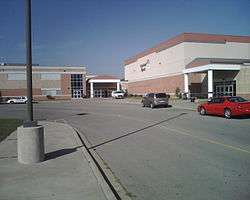
- Central Middle School – 1900 Thilenius St
- Central Junior High School – 205 Caruthers Street
- Central Senior High School – 1000 S Silver Springs Rd
- Career and Technology Center – 1080 S Silver Springs Rd
- Alternative Education Center – 330 N. Spring St
Private schools
- Cape Christian School – 1855 Perryville Rd
- Notre Dame Regional High School – 265 Notre Dame Dr
- Trinity Lutheran School - 55 North Pacific
- Eagle Ridge Christian School – 4210 State Highway K
- Parkview State School – 1020 S Parkway St
- Prodigy Leadership Academy – 1301 N Middle St
- St Mark Lutheran Preschool - 1900 Cape Lacroix Rd
- St. Mary's Catholic School – 210 S Sprigg St
- St. Vincent De Paul Grade School – 1912 Ritter St
- Deer Creek Christian Community – 2039 Cape Lacroix Rd
Colleges
- Cape Girardeau Partnership for Higher Education – 1080 South Silver Springs Road
- Metro Business College – 1732 N Kingshighway St
- Southeast Missouri State University – 1 University Plaza
- Southeast Hospital College of Nursing & Health Sciences – 2001 William St
- Eclipse School-Cosmetology - 52 S Plaza Way
- Trend Setters-Cosmetology Inc – 835 S Kingshighway
Transportation
The City of Cape Girardeau has established a Transportation Trust Fund that implements a .5% local sales tax. All of that money is used on transportation improvement projects. General projects are also included to keep the city’s streets in good condition.
On June 15, 2000 the Cape Girardeau County Commission passed Resolution 00-06 which formed the Cape Girardeau County Transportation Commission. The CGCTA now offers transportation to the citizens of Cape Girardeau County, which ultimately benefits the citizens of the city of Cape Girardeau. The services that the CGCTA offer are essentially buses and taxis.
In 2011, Cape Girardeau launched the Ride the City campaign. This dedicated 16 miles of bicycle lanes in city streets. There are lanes that are used only by bicycles and lanes where cars and bicycles can share space.
Bus and taxi services
Buses are offered to the citizens by the Cape Transit Authority and have several stops throughout the city. A general admission is $2, senior citizens are $1, and children ages 6 and under are free. Special pick-ups can be made to those who are disabled and live within three-fourths of mile from a designated stop. Greyhound buses are also available for long distance transit. The Cape Girardeau County Transit Authority handles the city's taxi service.
Air
The City of Cape Girardeau owns the Cape Girardeau Regional Airport. This is a full service airport that offers flights to and from Lambert International Airport in St. Louis, MO.
In popular culture
- James McMurtry's "Song for a Deck Hand's Daughter" is set in Cape Girardeau.
- The novel Killshot by Elmore Leonard is set in this city. The novel was adapted as a 2009 film based on Leonard's novel; numerous scenes were shot on location in Cape Girardeau.
- Scenes for the film Gone Girl (2014), which is set in the fictional North Carthage, Missouri, were shot in Cape Girardeau.[25][26]
- The thirteenth episode of the TV series Supernatural, "Route 666", which is said to take place in Cape Girardeau.
- The traditional folk song, "Hang Me, Oh Hang Me", most notably arranged by Dave Van Ronk, features a singer who has traveled the world, specifically mentioning visiting Cape Girardeau.[27]
- In the novel "Train Man" (1999) by P.T. Deutermann the Thebes bridge south of Cape Girardeau spanning the Mississippi River to Illinois is a key plot point in the race by FBI investigators to find persons unknown who are sequentially demolishing all railroad bridges that cross the River, causing mayhem and massive delays for all rail transportation in the contiguous United States.
Notable people


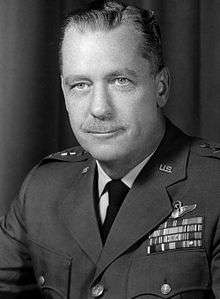
 Rod Jetton
Former state of Missouri Speaker of the House Peter Kinder
Lieutenant Governor
- Jacob M. Appel, novelist, lived in Cape Girardeau (1982–1984), set several books in Cape Girardeau[28][29]
- Leon Brinkopf (1926–1998), born and died in Cape Girardeau
- Karilyn Brown (born c. 1947), born in Cape Girardeau; Republican member of the Arkansas House of Representatives for Pulaski County since 2015
- Joseph Cable, a Medal of Honor recipient during the American Indian Wars
- Shirley Crites (1934–1990), All-American Girls Professional Baseball League player
- A. J. Ellis, catcher, Philadelphia Phillies, born in Cape Girardeau
- John Thomson Faris (1871–1949), clergyman, born in Cape Girardeau
- Andrew Conway Ivy, (1893–1978), president of the American Physiological Society (1939–1941)[30]
- Terry Jones (b. 1951), fundamentalist pastor of Dove World Outreach Center
- Peter Kinder, 46th Lieutenant Governor of Missouri (2005–present)
- Richard Kinder, businessman and philanthropist
- The Limbaugh family, including political commentators, brothers David and Rush Limbaugh
- Stephanie O'Sullivan, Principal Deputy Director of National Intelligence, born in Cape Girardeau
- Johnny Pott (b. 1935), golfer
- John Locke Scripps (1818–1866), journalist and biographer[31]
- Tony Spinner, guitarist and singer
- Billy Swan, singer who had a #1 hit song named "I Can Help" in 1974.
- Terry Teachout, writer
- Robert Henry Whitelaw (1854–1937), U.S. Congressman
- Susan Beth Scott (born 1992) 2008 and 2012 US Paralympic Medalist Swimmer
References
- 1 2 "US Gazetteer files 2010". United States Census Bureau. Archived from the original on July 14, 2012. Retrieved July 8, 2012.
- 1 2 "American FactFinder". United States Census Bureau. Retrieved July 8, 2012.
- ↑ http://www.census.gov/popest/data/cities/totals/2014/SUB-EST2014.html
- 1 2 "American FactFinder". United States Census Bureau. Archived from the original on September 11, 2013. Retrieved January 31, 2008.
- ↑ "U.S. Board on Geographic Names". United States Geological Survey. October 25, 2007. Retrieved January 31, 2008.
- ↑ Census: Cape Girardeau County, city and Jackson show large population growth
- ↑ "History of Cape Girardeau". City of Cape Girardeau. Retrieved April 9, 2014.
- ↑ "Hathawekela Indian Tribe History". Access Genealogy. 2013. Retrieved February 17, 2013.
- ↑ "Johnson-Wallace & Fish-Kirk Family Pedigree Charts Chief Paschal "Pas-Cal-We" Fish". May 19, 2012. Retrieved February 17, 2013.
- ↑ John Mack Faragher (1997). ""More Motley than Mackinaw": From Ethnic Mixing to Ethnic Cleansing on the Frontier of the Lower Missouri, 1783–1833". Retrieved February 17, 2013.
- ↑ "Anniversaries in 1949 of Events Recorded in The Missourian Files". Southeast Missouri. Cape Girardeau, Missouri. January 29, 1949.
- 1 2 Mary Charlotte Aubry Costello (1995). Climbing the Mississippi River Bridge by Bridge. Mary C. Costello. p. 48. ISBN 0-9644518-1-6.
- ↑ Dimitrakopoulos, Dionyssis G. Individual Rights and Liberties Under the U.S. Constitution: The Case Law of the U.S. Supreme Court. Boston: M. Nijhoff, 2007, p. 820.
- ↑ Preserve America Community
- ↑ Sanborn Maps for Missouri: Cape Girardeau, University of Missouri Digital Library. Accessed March 14, 2011.
- ↑ "Apple Creek Cemetery". Find a Grave. Retrieved April 5, 2011.
- ↑ "Salem Cemetery". Find a Grave. Retrieved April 5, 2011.
- ↑ "Old Lorimier Cemetery". Find a Grave. Retrieved April 5, 2011.
- ↑ "US Gazetteer files: 2010, 2000, and 1990". United States Census Bureau. February 12, 2011. Retrieved April 23, 2011.
- ↑ United States Department of Agriculture. United States National Arboretum. USDA Plant Hardiness Zone Map [Retrieved February 19, 2015].
- 1 2 3 4 5 "NowData - NOAA Online Weather Data". National Oceanic and Atmospheric Administration. Retrieved February 21, 2015.
- ↑ "Station Name: MO CAPE GIRARDEAU MUNI AP". National Oceanic and Atmospheric Administration. Retrieved February 21, 2015.
- ↑ "Annual Estimates of the Resident Population for Incorporated Places: April 1, 2010 to July 1, 2015". Retrieved July 2, 2016.
- ↑ "Missouri Population 1900 – 1990" (CSV). Missouri Census Data Center. Retrieved February 28, 2010.
- ↑ Lewis, Keith (October 20, 2013). "'Gone Girl' author talks about her Missouri roots". Southeast Missourian. Retrieved October 14, 2014.
- ↑ Williams, Joe (October 3, 2014). "'Gone Girl' shifts film focus to Missouri". St. Louis Post-Dispatch. Retrieved October 14, 2014.
- ↑ http://genius.com/Dave-van-ronk-hang-me-oh-hang-me-lyrics/
- ↑ Appel, JM. Phoning Home (2014)
- ↑ Scarsdale (NY) Inquirer, October 11, 2013
- ↑ "Andrew C. Ivy". Presidents. American Physiological Society. Retrieved March 22, 2015.
17th APS President (1939-1941)
- ↑ James Edmund Scripps, A Genealogical History of the Scripps Family and Its Various Alliances, R.L. Polk Printing Company, 1903
External links
| Wikimedia Commons has media related to Cape Girardeau, Missouri. |
- City of Cape Girardeau
- Sanborn Maps of Missouri Collection – Cape Girardeau at the University of Missouri
Municipalities and communities of Cape Girardeau County, Missouri, United States | ||
|---|---|---|
| Cities | 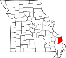 | |
| Villages | ||
| Townships | ||
| Unincorporated communities | ||
| Ghost towns | ||
| Footnotes | ‡This populated place also has portions in an adjacent county or counties | |
Municipalities and communities of Scott County, Missouri, United States | ||
|---|---|---|
| Cities |  | |
| Villages | ||
| Townships |
| |
| Unincorporated communities | ||
| Footnotes | ‡This populated place also has portions in an adjacent county or counties | |