Cape Grönland
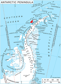
Location of Anvers Island in the Antarctic Peninsula region.
Cape Grönland (64°15′S 63°19′W / 64.250°S 63.317°WCoordinates: 64°15′S 63°19′W / 64.250°S 63.317°W) is a cape on the east side of the entrance to Gerritsz Bay which forms the northern extremity of Anvers Island, in the Palmer Archipelago, Antarctica.
The cape was discovered by a German expedition 1873–74, under Eduard Dallmann, who named it for his expedition ship, the Grönland. It was later charted by the French Antarctic Expedition, 1903–05, under Jean-Baptiste Charcot.[1]
References
- ↑ "Grönland, Cape". Geographic Names Information System. United States Geological Survey. Retrieved 2012-05-09.
![]() This article incorporates public domain material from the United States Geological Survey document "Grönland, Cape" (content from the Geographic Names Information System).
This article incorporates public domain material from the United States Geological Survey document "Grönland, Cape" (content from the Geographic Names Information System).
This article is issued from Wikipedia - version of the 11/21/2015. The text is available under the Creative Commons Attribution/Share Alike but additional terms may apply for the media files.