Capesterre-Belle-Eau
| Capesterre-Belle-Eau | |
|---|---|
|
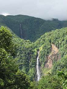
The Carbet waterfall, in Capesterre-Belle-Eau | |
 Location of the commune (in red) within Guadeloupe | |
| Coordinates: 16°03′N 61°34′W / 16.05°N 61.57°WCoordinates: 16°03′N 61°34′W / 16.05°N 61.57°W | |
| Country | France |
| Overseas region and department | Guadeloupe |
| Arrondissement | Basse-Terre |
| Canton | Canton de Capesterre-Belle-Eau |
| Government | |
| • Mayor | Joël Beaugendre |
| Area1 | 103.30 km2 (39.88 sq mi) |
| Population (2013)2 | 19,420 |
| • Density | 190/km2 (490/sq mi) |
| INSEE/Postal code | 97107 / 97130 |
|
1 French Land Register data, which excludes lakes, ponds, glaciers > 1 km² (0.386 sq mi or 247 acres) and river estuaries. 2 Population without double counting: residents of multiple communes (e.g., students and military personnel) only counted once. | |
Capesterre-Belle-Eau is a commune in the French overseas region and department of Guadeloupe, in the Lesser Antilles. It is located in the south-east of Basse-Terre Island. Capesterre-Belle-Eau covers an area of 103.3 km² (39.884 sq mi). The 1999 population was 19,568. The population density is 189 persons per km2. The inhabitants are called Capesterriens.
Etymology
Its name comes from an expression of the navy of the 17th century: cab-be-ground, which indicates a ground exposed to the east wind. The abundance of the cascades, the rivers and the water levels led to the addition of the phrase Belle Eau, hence the name Capesterre-Belle-Eau.
History
Petroglyphs discovered in the rivers of Peru and Bananier show the presence of American Indians.
On 4 November 1493, Christopher Columbus's second voyage unloaded there. Columbus would have met Amerindians. To commemorate this event, a bust of the navigator was raised in 1916 at the entry of Sainte-Marie.
In the 17th century, Charles Houël gave land to Dutch colonists driven out of Brazil, so that they could grow sugarcane there. After the abolition of chattel slavery in 1848, Indian indentured workers were hired to replace the plantation slaves. They built a temple in the Shangy district.
Near the Bois Debout estate, on a small way leading to an underwood, a flagstone in the Cemetery of the Slaves, requires the visitors to "Honor and Respect" the memory of the slaves. Several tens of unnamed tombs oriented "head towards Africa" are there.
Geography
The town is located at the south-east of the Basse-Terre and is located south of the Capesterre River. Basse-Terre, the capital is 26 km (16 mi) south-west and Pointe-à-Pitre is 35 km (22 mi) north-north-east.
Carbet Falls comprises three cascades.
Climate
Capesterre-Belle-Eau experiences rainfall throughout the year, with a wetter season between July and November that coincides with hurricane season. The city receives 2000–2500 mm of rainfall. Tropical heat brings constant highs of around 32 °C (89 °F) that drop to 20 °C (68 °F) at night.
Trade winds, called alizés, blow from the northeast and often temper the climate.
Economy
The economy is geared towards agriculture, particularly bananas, thanks to the quality of the soil. Farmers cultivate sugar cane, cocoa, vanilla, coffee, pineapples and vegetables of all kinds.
A rum distillery operates there.
Personalities
- Amédée Fengarol (1905-1951), Guadeloupean politician
- Sonny Rupaire, poet
- Henry Sidambarom (1863–1952), a Justice of the Peace and defender of the cause of Indian workers in Guadaloupe
- The mayor is Joël Beaugendre.
See also
References
External links
- Official website
- Official website (French)
| Wikimedia Commons has media related to Capesterre-Belle-Eau. |