Capitol Hill Historic District (Salt Lake City, Utah)
|
Capitol Hill Historic District | |
|
The Utah State Capitol, sitting at the top of Capitol Hill, for which the historic district is named | |
  | |
| Location |
Roughly bounded by Beck, Main and Wall Sts., 300 North, Victory Rd. and Capitol Blvd., (original), and |
|---|---|
| Coordinates | 40°46′43″N 111°53′33″W / 40.77861°N 111.89250°WCoordinates: 40°46′43″N 111°53′33″W / 40.77861°N 111.89250°W |
| Built | 1850 |
| Architect | Multiple |
| Architectural style |
Mixed (more Than 2 Styles From Different Periods)(original) Mid 19th Century Revival, Late Victorian (increase) |
| NRHP Reference # | 82004135 and 01001451[1] |
| Added to NRHP |
August 2, 1982 (original) January 11, 2002 (increase) |
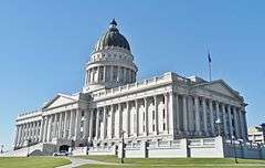
The Capitol Hill Historic District in Salt Lake City, Utah was listed on the National Register of Historic Places in 1982. It was originally roughly bounded by Beck, Main and Wall Sts., 300 North, Victory Rd. and Capitol Blvd., and includes the Utah State Capitol.[1] The district was increased in 2002 to include an area roughly bounded by 300 North, 400 West, 800 North, Wall St., and 200 West.[1][2][3]
See also
References
- 1 2 3 National Park Service (2008-04-15). "National Register Information System". National Register of Historic Places. National Park Service.
- ↑ Henry 0. Whiteside (November 1980). "National Register of Historic Places Inventory/Nomination: Capitol Hill Historic District" (PDF). National Park Service. and accompanying 35 photos
- ↑ Korral Broschinsky (November 2, 2001). "National Register of Historic Places Registration: Capitol Hill Historic District (Boundary Increase)" (PDF). National Park Service. and accompanying 64 photos
| Topics | |
|---|---|
| Lists by states |
|
| Lists by insular areas | |
| Lists by associated states | |
| Other areas | |
| |
This article is issued from Wikipedia - version of the 11/27/2016. The text is available under the Creative Commons Attribution/Share Alike but additional terms may apply for the media files.