Carrbrook

Coordinates: 53°30′N 2°02′W / 53.5°N 2.03°W
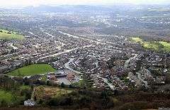
Carrbrook is an area in the east of Stalybridge, in Greater Manchester,[1] England. The area still has many seventeenth and eighteenth century buildings. Much of the late-nineteenth and early-twentieth century village was built during the industrial boom brought by the printworks. Modern Housing estates were built next to the old village on the lower flank of Harridge Pike from the 1970s. The view to the east of Carrbrook is dominated by the steep-sided Buckton Hill, on the summit of which is located Buckton Castle. Neighbouring communities include Millbrook, Heyheads and Micklehurst.
Music
Every year on Whit Friday, Carrbrook is host to a very lively and popular Brass Band Contest outside the Buckton Vale Institute in Carrbrook Village.
References
- ↑ "Greater Manchester Gazetteer". Greater Manchester County Record Office. Places names - C. Archived from the original on 18 July 2011. Retrieved 26 September 2007.
External links
- Carrbrook Brass Band
- A walk through Carrbrook provided by the Tameside Borough Council website.
- Carrbrook Village - Community website.
- Carrbrook Heritage Trail - A local history project commissioned on behalf of the British National Lottery heritage fund by the Carrbrook Heritage Group.
- Tameside Local History Forum
- Carrbrook Whit Friday Brass Band Contest