Cass Lake (Minnesota)
| Cass Lake | |
|---|---|
 Canoe Tripping by Girl Scouts of Camp Cassaway on Cass Lake, Minnesota. 1962. | |
| Location | Beltrami / Cass counties, Minnesota, United States |
| Coordinates | 47°25′05″N 94°32′21″W / 47.4181°N 94.5392°WCoordinates: 47°25′05″N 94°32′21″W / 47.4181°N 94.5392°W |
| Primary inflows | Mississippi River / Turtle River / Pike Bay |
| Primary outflows | Mississippi River |
| Basin countries | United States |
| Surface area | 15,958 acres (64.58 km2) |
| Max. depth | 120 ft (37 m) |
| Surface elevation | 1,301 ft (397 m) |
| Islands | Star Island, Potato Islands, Cedar Island, unnamed island |
| Settlements | Cass Lake |
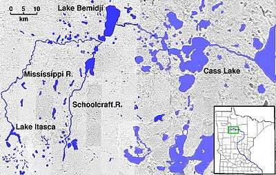
Cass Lake is a glacially-formed lake in north central Minnesota in the United States. It is approximately 10 mi (16 km) long and 7 mi (11 km) wide, located in Cass and Beltrami counties, within the Chippewa National Forest and the Leech Lake Indian Reservation, adjacent to its namesake city of Cass Lake. In the Ojibwe language, it is called Gaa-miskwaawaakokaag (where there are many red cedar), and was known to early explorers and traders in French as Lac du Cedre Rouge, and English as Red Cedar Lake. It is the 11th largest lake in Minnesota, and the 8th largest lake lying entirely within the borders of the state.
The lake contains five islands, including Star Island, Cedar Island, the two Potato Islands, and a small unnamed island. The Mississippi River flows through the lake from west to east. A second major stream, the Turtle River, enters the lake from the north. The lake has a large littoral area, particularly around Cedar Island. Star Island is notable in that it contains the 199 acres (0.81 km2)-sized Lake Windigo, thus forming "a lake within an island within a lake". .
In July 1820, an expedition led by General Lewis Cass visited the lake. They were prevented from traveling further upstream by low water, and so designated the lake as the headwaters of the Mississippi because below this point, the river is navigable throughout the ice-free season. In June 1832, Henry Schoolcraft, who had been a member of the 1820 expedition, designated the source of the river as being further upstream at Lake Itasca, the source of the perennial stream. Subsequent to the Cass Expedition of 1820, the lake was renamed Cass Lake in order to distinguish it from Red Cedar Lake (known today as Cedar Lake) in Aitkin County.
The lake is popular destination for recreational fishing, boating, and swimming. The lake is known for its walleye, northern pike, muskellunge, and yellow perch fisheries. Tullibee are important forage fish. There are numerous campgrounds and resorts located on its shores. The southern and eastern shores of the lake, as well as all the islands, are protected within the Ten Section Area of the Chippewa National Forest. Norway Beach recreation area is located at the southeast corner of the lake, and contains Norway Beach Lodge, a notable example of Civilian Conservation Corps-built Finnish-style log architecture. The city of Cass Lake sits near the southwestern side of the lake. Formerly, the lake played an important role in the lumber industry. Log booms were towed across the lake by steamboat from surrounding lakes and streams to either be sawed into lumber at local mills, or transported elsewhere by railroad.
Historically, Cass Lake was considered to be much larger. Pike Bay is a 4,760 acres (19.3 km2) lake lying to the south of Cass Lake; the two lakes are connected by a narrow 0.5 mi (0.80 km) long channel. Formerly, the two lakes were connected by a 0.6 mi (0.97 km) wide shallow narrows. Beginning in 1898, construction of a railroad, and later highway and pipeline, across the narrows led to decreased currents through and increased sedimentation in the narrows. The two bodies of water are now generally considered separate lakes, although Pike Bay retains its old name.
The lake level is maintained and stabilized by Knutson Dam, built in 1924 to replace earlier brush and log dams built by lumber companies. Knutson Dam is one of the few dams managed by the U.S. Forest Service.
On the small isthmus between Cass Lake and neighboring Buck Lake lies Camp Chippewa, a boys camp founded in 1935. Another camp, UniStar, lies on a portion of Star Island.