Caudebec-en-Caux
| Caudebec-en-Caux | |
|---|---|
 Caudebec-en-Caux | |
|
Location within Normandy region  Caudebec-en-Caux | |
| Coordinates: 49°31′38″N 0°43′37″E / 49.5272°N 0.7269°ECoordinates: 49°31′38″N 0°43′37″E / 49.5272°N 0.7269°E | |
| Country | France |
| Region | Normandy |
| Department | Seine-Maritime |
| Arrondissement | Rouen |
| Canton | Notre-Dame-de-Gravenchon |
| Intercommunality | Caux vallée de Seine |
| Government | |
| • Mayor (2008–2014) | Bastien Coriton |
| Area1 | 4.93 km2 (1.90 sq mi) |
| Population (2006)2 | 2,376 |
| • Density | 480/km2 (1,200/sq mi) |
| Time zone | CET (UTC+1) |
| • Summer (DST) | CEST (UTC+2) |
| INSEE/Postal code | 76164 / 76490 |
| Elevation |
1–116 m (3.3–380.6 ft) (avg. 5 m or 16 ft) |
|
1 French Land Register data, which excludes lakes, ponds, glaciers > 1 km² (0.386 sq mi or 247 acres) and river estuaries. 2 Population without double counting: residents of multiple communes (e.g., students and military personnel) only counted once. | |
Caudebec-en-Caux is a former commune in the Seine-Maritime department in the Normandy region in northern France. On 1 January 2016, it was merged into the new commune of Rives-en-Seine.[1]
Geography
Caudebec-en-Caux is located 27 miles (43 km) W.N.W. of Rouen, on the right bank of the River Seine. The tidal bore in the estuary of the Seine which is known as the mascaret in French, but locally as the barre, used to be well seen at this point. The development of the industrial polder towards Harfleur has changed the geometry of the estuary so that mascaret now seems to be a phenomenon of the past.
Since 1977 Caudebec has been served by the Pont de Brotonne, one of three bridges built across the Seine, downstream from Rouen since 1960, to replace the many ferries so making vehicular access between the Pays de Caux and the Autoroute A13 easier.
History
Caudebec is one of numerous places in Normandy having names which are clearly derived from a Scandinavian language. Caldebec Abt 1025 (like Caldbeck, Caldebeck 1060, Cumberland.) derives from the old Danish kaldr bekkr: cold stream, cold brook.
In May 1592 during the French Wars of Religion Caudebec had been taken by Spanish and French Catholic League forces of Duke of Parma but was trapped by an army under Henry IV of France. Parma though wounded then made a miraculous escape avoiding complete defeat but died at Arras.
Heraldry
.svg.png) |
formerly: Azure, 3 smelt argent. now: Azure, in pale 3 salmon argent.[2] |
Sights
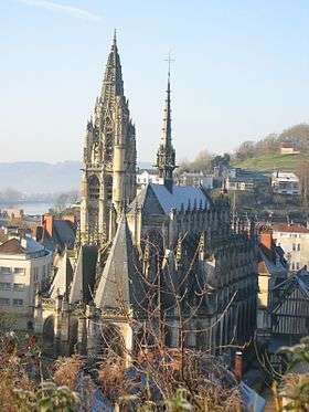
The chief architectural interest of the town lies in its Flamboyant church, which was constructed during the 15th and the early 16th centuries.[3] Round its top run balustrades formed of Gothic letters, which read as part of the Magnificat. Its west portal, the decoration of the spire of the tower, and its stained glass are among the features which make it one of the finest churches of the Rouen diocese.
- In the town are also
- Maison des Templiers (The Templars' House) from the twelfth and thirteenth centuries. The building was saved by a society set up for the purpose and houses a small museum of local archaeology and history. A domestic building of this period is a rarity.
- The former prison from the fourteenth century.
- Hôtel du Bailli, a town house.
- Hôtel de ville (Town Hall) from fround 1800.
- The riverside embankments (Les Quais).
- Musée de la marine de Seine, on the history of river navigation.
- Just outside the town:
- Château d'Etelan a renaissance château overlooking the final loop of the river Seine
- The short length of riverside road between Caudebec and St Wandrille, passes under the Pont de Brotonne, a high-level cable-stayed bridge.
- Monument du Latham 47
- Fontenelle Abbey (Abbaye de Saint-Wandrille), in the nearby village of Saint-Wandrille-Rançon.
Economy
Its industries include tanning and leather-currying, and there is trade in grain. The port has a small trade in coal, live-stock and farm produce.
Caudebec-en-Caux in fiction
- Caudebec-en-Caux (though shortened to 'Caudebec') is the site of the death of the character Captain William Bush, in C.S. Forester's novel Lord Hornblower, part of the popular Horatio Hornblower series set during the Napoleonic Wars. Bush, Hornblower's loyal companion for much of the series, was killed due to an explosion in a minor military operation in the Seine estuary near to the town of Caudebec.[4][5]
- Much of the action in They Wouldn't Be Chessmen by A. E. W. Mason takes place in Caudebec.
Notable people
- Thomas Basin, historian, was born here in 1412.
- Anthony Ashley-Cooper, 10th Earl of Shaftesbury was raised here after his father, the 9th Earl of Shaftesbury died in 1947. The 10th Earl's mother was the French-born Françoise Soulier, daughter of Georges Soulier.
- François Duprat (1941–1978), French writer, was killed here.
- Hippolyte Sebron (1801-1879), painter and associate of Louis Daguerre, was born here.
See also
References
- Hat making history with the Huguenots in Caudebec-en-Caux during a time of religious intolerance Link to blog
- INSEE
-
 This article incorporates text from a publication now in the public domain: Chisholm, Hugh, ed. (1911). "Caudebec-en-Caux". Encyclopædia Britannica (11th ed.). Cambridge University Press.
- ↑ Arrêté préfectoral 16 December 2015
- ↑ http://www.newgaso.fr/lecture_fiche_commune.php3?page=f76164
- ↑ Steinke, William August. The Flamboyant Gothic Church of Caudebec-En-Caux: A Neglected Masterpiece of French Medieval Architecture. Thesis (Ph. D.)--New York University, 1982.
- ↑ Forester, C.S., (1946) Lord Hornblower, Michael Joseph, London
- ↑ Forester, C.S., (1964), The Hornblower Companion, Michael Joseph, London.
| Wikimedia Commons has media related to Cauedebec-en-Caux. |