Caylloma Province
| Caylloma | |
|---|---|
| Province | |
|
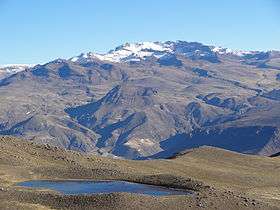
Mismi as seen from the southeast | |
 Location of Caylloma in the Arequipa Region | |
| Country | Peru |
| Region | Arequipa |
| Capital | Chivay |
| Government | |
| • Mayor | Jorge Modesto Cueva Tejada (2007) |
| Area | |
| • Total | 14,019.46 km2 (5,412.94 sq mi) |
| Population (2005 census) | |
| • Total | 72,214 |
| • Density | 5.2/km2 (13/sq mi) |
| UBIGEO | 0405 |
Caylloma Province is the largest of eight provinces in the Arequipa Region of Peru.
Geography
The Chila mountain range traverses the province. One of the highest mountains of the province is Mismi. Other mountains are listed below:[1]
- Allqamarini
- Ananta
- Ankachita
- Anqasi
- Anta Salla
- Aqu Kulluna
- Chullunkhäni
- Chulluqani
- Chunkara
- Chuqi Kuraw
- Chuqi Pirwa
- Chila
- Ch'uwaña (Huanca)
- Ch'uwaña (Lari)
- Hatun Chunkara
- Hatun Pila
- Hatun Siqita
- Huch'uy Q'asa
- Iru Muqu
- Janq'u Quta
- Jañuma Pirwa
- Jayu Laqhi
- Jichu Qullu
- Jichu Qullu (Chuca)
- Karpa Muqu
- Kimsa Chata
- Kiwicha
- Kunturi
- K'ayrawiri
- Laramani
- Lawraq Muqu
- Llallawa
- Llimayuq
- Lluqu
- Minasniyuq
- Minaspata
- Misa Chunkara
- Parwayani
- Pilluni
- Pirwa
- Puka Puka
- Puka Urqu
- Pukara (Lari)
- Puma Urqu
- P'isaqani
- Qillqa
- Qillwa
- Qullqiri
- Q'illa Q'illa
- Q'illu Q'illu
- Q'inchu
- Salla P'ukuruyuq
- Saya Sirk'a
- Sillani
- Tiklla (Caylloma-Tuti)
- Tiklla (Lari)
- T'allani Urqu
- T'ula Muqu
- Wajchani
- Wallatani
- Wankara
- Wanqani
- Warank'anthi
- Wayllaqucha
- Wiluma
- Wiska Wiska
- Wisk'achayuq
- Wiswillani
- Yana Salla
- Yana Surk'a
- Yaritani
- Yuraq Apachita
Political division
The province is divided into twenty districts which are:
Points of interest
The Colca Canyon lies in the Huambo and Callalli districts.[2]
See also
References
- ↑ escale.minedu.gob.pe - UGEL maps of the Caylloma Province 1 and 2 (Arequipa Region)
- ↑ Colca Peru - Attractions in Colca
| |
|---|---|
Coordinates: 15°38′12″S 71°36′08″W / 15.63667°S 71.60222°W
This article is issued from Wikipedia - version of the 3/7/2016. The text is available under the Creative Commons Attribution/Share Alike but additional terms may apply for the media files.