Cedar Bluff State Park
| Cedar Bluff State Park | |
| Kansas State Park | |
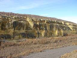 Limestone on the edge of Cedar Bluff | |
| Country | |
|---|---|
| State | |
| County | Trego County, Kansas |
| Elevation | 2,185 ft (666 m) [1] |
| Coordinates | 38°46′29″N 99°46′18″W / 38.77472°N 99.77167°WCoordinates: 38°46′29″N 99°46′18″W / 38.77472°N 99.77167°W |
| Area | 850 acres (344.0 ha) |
| Founded | 1962 |
| Management | Kansas Department of Wildlife, Parks and Tourism |
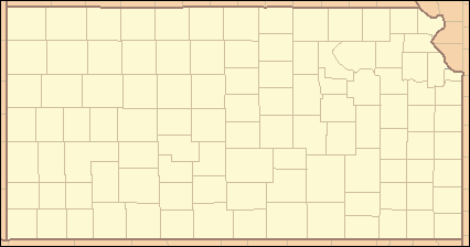 Location of Cedar Bluff State Park in Kansas
| |
Cedar Bluff State Park is a state park in Trego County, Kansas, United States. It is located 21 miles (34 km) southeast of WaKeeney and 23 miles (37 km) southwest of Ellis.
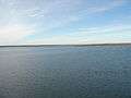
The park is divided into two areas,[2] comprising 850 acres (340 ha), straddling the 6,800-acre (2,800 ha) Cedar Bluff Reservoir. The Bluffton Area—300 acres (120 ha) on the north shore—is the most developed and receives extensive use. The Page Creek Area—500 acres (200 ha) on the south shore—offers primitive camping as well as 36 utility sites. West of the Page Creek Area are the juniper-lined, 100-foot-tall (30 m) limestone bluffs from which the reservoir's name was derived (junipers were often misidentified as "cedars" by early settlers).
Threshing Machine Canyon, the site of an 1850s Native American attack on a wagon train bearing a threshing machine, is accessed by a road west of the park. In the historic canyon one can find carvings dating back to the mid-19th century.
Gallery


See also
References
- ↑ "Cedar Bluff State Park Office". Geographic Names Information System. United States Geological Survey. 2011-02-03. Retrieved 2012-11-22.
- ↑ "Cedar Bluff State Park". Kansas State Parks. Kansas Department of Wildlife, Parks and Tourism. Retrieved 2012-11-22.
External links
- "Cedar Bluff State Park". Kansas Department of Wildlife, Parks and Tourism. Retrieved 2012-11-11.