Cedar Run (Pennsylvania)
| Cedar Run | |
| Creek | |
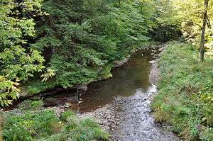 Downstream from bridge at Mine Hole Run | |
| Country | United States |
|---|---|
| State | Pennsylvania |
| County | Tioga County, Lycoming County |
| Source | near Leetonia |
| - location | Tioga State Forest, Tioga County, Pennsylvania |
| - elevation | 2,138 ft (652 m) [1] |
| - coordinates | 41°39′05″N 77°32′08″W / 41.65139°N 77.53556°W [2] |
| Mouth | Pine Creek |
| - location | Cedar Run (community), Lycoming County |
| - elevation | 784 ft (239 m) [2] |
| - coordinates | 41°31′40″N 77°26′48″W / 41.52778°N 77.44667°WCoordinates: 41°31′40″N 77°26′48″W / 41.52778°N 77.44667°W [2] |
| Length | 11.4 mi (18.3 km) |
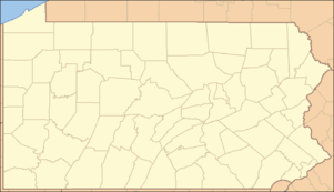 Location of the mouth of Cedar Run in Pennsylvania
| |
Cedar Run is an 11.4-mile-long (18.3 km)[3] tributary of Pine Creek in Lycoming and Tioga counties, Pennsylvania in the United States.[4]
Cedar Run joins Pine Creek at the community of Cedar Run.[4]
See also
References
- ↑ Source elevation derived from Google Earth search using GNIS source coordinates.
- 1 2 3 "Cedar Run". Geographic Names Information System (GNIS). United States Geological Survey. August 2, 1979. Retrieved August 30, 2012.
- ↑ U.S. Geological Survey. National Hydrography Dataset high-resolution flowline data. The National Map Archived 2012-04-05 at WebCite, accessed August 8, 2011
- 1 2 Gertler, Edward. Keystone Canoeing, Seneca Press, 2004. ISBN 0-9749692-0-6
This article is issued from Wikipedia - version of the 11/19/2016. The text is available under the Creative Commons Attribution/Share Alike but additional terms may apply for the media files.