Ceronda
| Ceronda | |
|---|---|
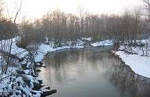 The Ceronda near Druento | |
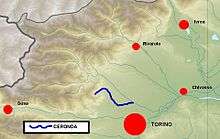 Ceronda location within the province of Turin | |
| Country | Italy: province of Turin |
| Basin | |
| Main source |
Monte Colombano northern slopes 1,350 m (4,430 ft) |
| River mouth |
Stura di Lanzo in Venaria Reale 242.0 m (794.0 ft) |
| Basin size | 142.1 km2 (54.9 sq mi)[1] |
| Physical characteristics | |
| Length | 22 km (14 mi)[2] |
| Discharge |
|
| Features | |
| Tributaries |
|
The Ceronda (Piedmontese: Sunder or Srunda)[3] is a 22-kilometre (14 mi) long creek in the Piedmont region in northwestern Italy.
Geography
It is formed from several streams that drain the northern slopes of Monte Colombano and converge near Varisella. Flowing from southwest to northeast, it reaches Fiano where it gets out of the Alps and enters into the Po plain turning towards south. After receiving from the right its main tributary, the Casternone, it crosses the Mandria nature park and finally flows into the river Stura di Lanzo in Venaria Reale.
References
- 1 2 AA.VV. (2004). "Elaborato I.c/7". Piano di Tutela delle Acque - Revisione del 1º luglio 2004; Caratterizzazione bacini Idrografici (PDF). Regione Piemonte. Retrieved 2012-06-05.
- ↑ AA.VV. (2004). "Elaborato I.c/5". Piano di Tutela delle Acque - Revisione del 1º luglio 2004; Caratterizzazione bacini Idrografici (PDF). Regione Piemonte. Retrieved 2012-06-05.
- ↑ "Una piacevole sorpresa - La Cassa - Il paese, la gente, le idee". La Cassa. Retrieved 2012-06-11.
Other projects
![]() Media related to Ceronda at Wikimedia Commons
Media related to Ceronda at Wikimedia Commons
Coordinates: 45°07′52″N 7°38′36″E / 45.13111°N 7.64333°E
This article is issued from Wikipedia - version of the 6/18/2016. The text is available under the Creative Commons Attribution/Share Alike but additional terms may apply for the media files.