Cerreto Guidi
| Cerreto Guidi | |
|---|---|
| Comune | |
| Comune di Cerreto Guidi | |
|
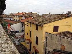
Panorama of Cerreto Guidi | |
 Cerreto Guidi Location of Cerreto Guidi in Italy | |
| Coordinates: 43°46′N 10°53′E / 43.767°N 10.883°ECoordinates: 43°46′N 10°53′E / 43.767°N 10.883°E | |
| Country | Italy |
| Region | Tuscany |
| Province / Metropolitan city | Province of Florence (FI) |
| Area | |
| • Total | 49.3 km2 (19.0 sq mi) |
| Elevation | 123 m (404 ft) |
| Population (Dec. 2004) | |
| • Total | 10,126 |
| • Density | 210/km2 (530/sq mi) |
| Time zone | CET (UTC+1) |
| • Summer (DST) | CEST (UTC+2) |
| Postal code | 50050 |
| Dialing code | 0571 |
| Website | Official website |
Cerreto Guidi is a comune (municipality) in the Province of Florence in the Italian region Tuscany, located about 30 kilometres (19 mi) west of Florence. As of 31 December 2004, it had a population of 10,126 and an area of 49.3 square kilometres (19.0 sq mi).[1]
Cerreto Guidi borders the following municipalities: Empoli, Fucecchio, Lamporecchio, Larciano, San Miniato, Vinci.
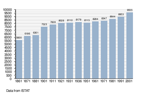
Demographic evolution
References
External links
| Wikimedia Commons has media related to Cerreto Guidi. |
This article is issued from Wikipedia - version of the 7/3/2015. The text is available under the Creative Commons Attribution/Share Alike but additional terms may apply for the media files.