Certosa di Pavia (comune)
| Certosa di Pavia | ||
|---|---|---|
| Comune | ||
| Comune di Certosa di Pavia | ||
|
The facade of the Certosa di Pavia Monastery | ||
| ||
.svg.png) Certosa di Pavia within the Province of Pavia | ||
 Certosa di Pavia Location of Certosa di Pavia in Italy | ||
| Coordinates: 45°15′N 09°09′E / 45.250°N 9.150°ECoordinates: 45°15′N 09°09′E / 45.250°N 9.150°E | ||
| Country | Italy | |
| Region | Lombardy | |
| Province / Metropolitan city | Pavia (PV) | |
| Frazioni | Cascine Calderari, Samperone, Torre del Mangano,[1] Torriano | |
| Government | ||
| • Mayor |
Corrado Petrini[2] (since 8-6-2009) | |
| Area | ||
| • Total | 10 km2 (4 sq mi) | |
| Elevation | 90 m (300 ft) | |
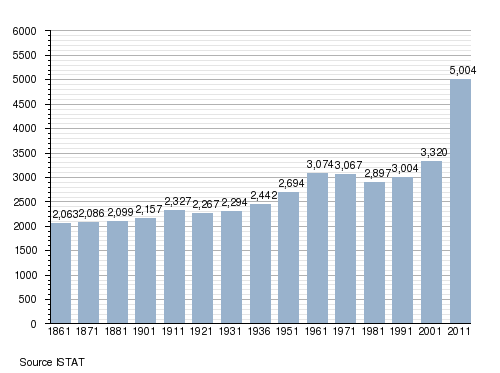
| Population (January 31, 2013) | ||
| • Total | 5,114 | |
| • Density | 510/km2 (1,300/sq mi) | |
| Time zone | CET (UTC+1) | |
| • Summer (DST) | CEST (UTC+2) | |
| Postal code | 27100 | |
| Dialing code | 0382 | |
| Website | Official website | |
.jpg)
-Stemma.png)
Certosa di Pavia (Pavese dialect: Certusa dè Pavia or la Certùsa) is a town and comune (municipality) in the province of Pavia, Lombardy. It is famous for the homonymous religious complex. As of 2013 its population was of 5,114.[3]
History
The comune was created in 1929 by the former communes of Torre del Mangano, Torriano and Borgarello (which became again autonomous in 1958).[4]
Geography
The municipality is located in north of Pavia and 30 km in south of Milan. It borders with the municipalities of Borgarello, Giussago, Marcignago, Pavia and Vellezzo Bellini. Its territory is formed by the hamlets (frazioni) of Cascine Calderari, Samperone, Torre del Mangano (municipal seat) and Torriano.
Demographics
Gallery
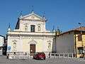 St. Michael's church in Torre del Mangano
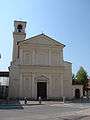 St. Apollinare's church in Torriano
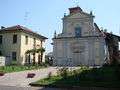 St. Brizio's church in Samperone
See also
References
- ↑ municipal seat
- ↑ (Italian) Mayor and municipal council of Certosa di Pavia Archived January 16, 2014, at the Wayback Machine.
- ↑ (Italian) Source: Istat 2013
- ↑ (Italian) History of the municipality of Certosa di Pavia Archived January 16, 2014, at the Wayback Machine.
External links
![]() Media related to Certosa di Pavia at Wikimedia Commons
Media related to Certosa di Pavia at Wikimedia Commons
- (Italian) Certosa di Pavia official website