Cerusa
| Cerusa | |
|---|---|
 | |
 | |
| Country | Italy |
| Basin | |
| Main source |
Ligurian Apennines 376 m (1,234 ft) |
| River mouth |
Ligurian Sea in Voltri (GE, Italy) 0 m (0 ft) 44°25′36.48″N 8°44′33.8″E / 44.4268000°N 8.742722°ECoordinates: 44°25′36.48″N 8°44′33.8″E / 44.4268000°N 8.742722°E |
| Basin size | 24 km2 (9.3 sq mi)[1] |
| Physical characteristics | |
| Length | 10.7 km (6.6 mi)[1] |
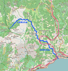
The Cerusa is a 10.7-kilometre (6.6 mi) stream of Liguria (Italy).
Geography
The river is formed at 376 m by the confluence of two streams, Rio Gava and Rio delle Cave,[2] in the Ligurian Apennines. The river then flows through the Valle Cerusa and crosses the villages of Fiorino, Fabbriche di Voltri e Fullo. Heading south reaches Voltri and ends its course in the Ligurian Sea, after being crossed by Autostrada A10, Genoa–Ventimiglia railway and Aurelia national road.
Cerusa basin (24 km2) is totally included in the Province of Genova.[3]
Main tributaries
- Left hand:
- Rio delle Cave.
- Right hand:
- Rio Gava;
- Rio Secco.
History
The Département de la Ceruse or Dipartimento della Cerusa of Ligurian Republic took its name at the end of the XVIII century from the stream.[4]
References
- 1 2 Ufficio Pianificazione territoriale (2013). AMBITI REGIONALI DI BACINO 12 e 13 (PDF). cartogis.provincia.genova.it (in Italian). Provincia di Genova. Retrieved October 19, 2015.
- ↑ Direzione Pianificazione Generale e di Bacino (2009). Il bacino del torrente Cerusa (PDF). cartogis.provincia.genova.it (in Italian). Provincia di Genova. Retrieved October 19, 2015.
- ↑ 1:25.000 map of the Istituto Geografico Militare, on-line on www.pcn.minambiente.it/viewer
- ↑ Gazzetta universale (in Italian). 1797. Retrieved October 19, 2015.
![]() Media related to Cerusa at Wikimedia Commons
Media related to Cerusa at Wikimedia Commons
This article is issued from Wikipedia - version of the 5/6/2016. The text is available under the Creative Commons Attribution/Share Alike but additional terms may apply for the media files.