Château de Malmaison
| Château de Malmaison | |
|---|---|
 The Château de Malmaison | |
| General information | |
| Type | Château |
| Architectural style | Renaissance, Empire |
| Town or city | Rueil-Malmaison |
| Country | France |
The Château de Malmaison (French pronunciation: [ʃɑ.to də‿mal.mɛzɔ̃]) is a French château. It is located near the western bank of the Seine about 15 kilometres (9.3 mi) west of the centre of Paris in Rueil-Malmaison.
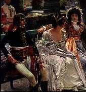
Formerly the residence of Empress Joséphine de Beauharnais, along with the Tuileries it was the headquarters of the French government from 1800 to 1802, and Napoleon's last residence in France at the end of the Hundred Days in 1815.
History

Joséphine de Beauharnais bought the manor house in April 1799 for herself and her husband, General Napoléon Bonaparte, the future Napoléon I of France, at that time away fighting the Egyptian Campaign. Malmaison was a run-down estate, seven miles (12 km) west of central Paris that encompassed nearly 150 acres (0.61 km2) of woods and meadows.
Upon his return, Bonaparte expressed fury at Joséphine for purchasing such an expensive house with the money she had expected him to bring back from the Egyptian campaign. The house, for which she had paid well over 300,000 francs, needed extensive renovations, and she spent a fortune doing so. Malmaison would bring great happiness to the Bonapartes. Joséphine's daughter, Hortense would call it "a delicious spot".
Joséphine endeavored to transform the large estate into "the most beautiful and curious garden in Europe, a model of good cultivation". She located rare and exotic plants and animals to enhance the gardens. Joséphine wrote: "I wish that Malmaison may soon become the source of riches for all [of France]"...
In 1800, Joséphine built a heated orangery large enough for 300 pineapple plants. Five years later, she ordered the building of a greenhouse, heated by a dozen coal-burning stoves. From 1803 until her death in 1814, Josephine cultivated nearly 200 new plants in France for the first time.
The property achieved enduring fame for its rose garden. Empress Joséphine had the Belgian artist Pierre-Joseph Redouté (1759–1840) record her roses (and lilies), and prints of these works sell quite well, even today. She created an extensive collection of roses, gathering plants from her native Martinique and from other places around the world. She grew some 250 varieties of roses. From the foreword to Jardin de la Malmaison (1803):
- You have gathered around you the rarest plants growing on French soil...as we inspect them in the beautiful gardens of Malmaison, an impressive reminder of the conquests of your illustrious husband...
Birds and animals of all sorts began to enrich her garden, where they were allowed to roam free among the grounds. At the height of her days at Malmaison, Joséphine had the company of kangaroos, emus, black swans, zebras, sheep, gazelles, ostriches, chamois, a seal, antelopes and llamas to name a few. Some were from the Baudin expedition.
After her divorce from Napoléon, Joséphine received Malmaison in her own right, along with a pension of 5 million francs a year, and remained there until her death in 1814. Napoléon returned and took residence in the house after his defeat at the Battle of Waterloo (1815), before his exile to the island of Saint Helena.
In 1842 Malmaison was purchased by Maria Christina, widow of King Ferdinand VII of Spain; she lived there with her second husband Agustín Fernando Muñoz, 1st Duke of Riánsares. In 1861 Maria Christina sold the property to Napoleon III.
Malmaison was fully restored by the famous French architect Pierre Humbert in the early 20th century. It is now considered an important historical monument.[1]
Present times
The public can visit the manor house as a Napoleonic musée national. The museum lies on RN 13 (route nationale 13) from Paris and bus 258 from RER A "Grande Arche" station.
Gallery
Exterior
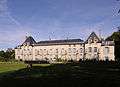 View of the southwest facade of the Manor House
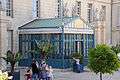 Main entrance in the Manor House
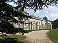 The Manor house seen by the cedar of Marengo (southwest facade)
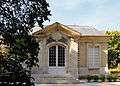 Pavillon Osiris in the Garden of Malmaison
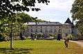 View of the main entrance and the main facade (northeast)
Interior
- Assorted rooms
 Chamber of Napoléon
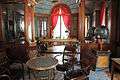
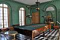 Billiard room
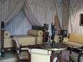
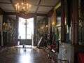 Music room
 Joséphine's service - Sèvres porcelain
- Library
 Library created in 1800 by Charles Percier and Pierre-François-Léonard Fontaine
 Furniture in mahogany is the creation of the brothers Jacob-Desmalter
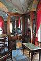 The celestial globe of Nicolas Constant Lemaire, dating from 1788
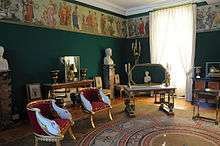
- Apartment of Joséphine
 Simply decorated anteroom
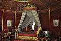 Luxurious chamber of Joséphine de Beauharnais with the bed of origin
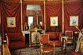 The wall decoration and the furniture were restored by Napoleon III in 1865
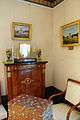 Common Chamber in Joséphine's apartment
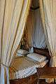 Bed in Joséphine's common chamber
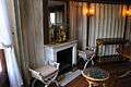 Bathroom in Joséphine's apartment
- Dining room
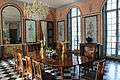 Decoration designed by Charles Percier and Pierre-François-Léonard Fontaine
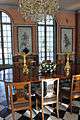 Murals paintings by Louis Lafitte (1800) represent six pompéiennes dancers
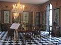 Dining room
References
External links
| Wikimedia Commons has media related to Château de Malmaison. |
- Official site (French)
- "Josephine's garden", Orient Express Magazine, Vol. 19, No. 1, by HRH Princess Michael of Kent.
Coordinates: 48°52′15″N 2°10′01″E / 48.87083°N 2.16694°E