Charente-Maritime
| Charente-Maritime | |||
|---|---|---|---|
| Department | |||
|
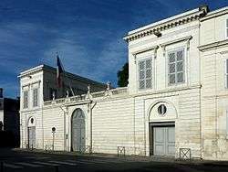
Prefecture building of the Charente-Maritime department, in La Rochelle | |||
| |||
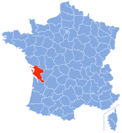 Location of Charente-Maritime in France | |||
| Coordinates: 45°57′N 0°58′W / 45.950°N 0.967°WCoordinates: 45°57′N 0°58′W / 45.950°N 0.967°W | |||
| Country | France | ||
| Region | Nouvelle-Aquitaine | ||
| Prefecture | La Rochelle | ||
| Subprefectures |
Jonzac Rochefort Saintes Saint-Jean-d'Angély | ||
| Government | |||
| • President of the General Council | Dominique Bussereau (UMP) | ||
| Area1 | |||
| • Total | 6,864 km2 (2,650 sq mi) | ||
| Population (2013) | |||
| • Total | 633,417 | ||
| • Rank | 39th | ||
| • Density | 92/km2 (240/sq mi) | ||
| Time zone | CET (UTC+1) | ||
| • Summer (DST) | CEST (UTC+2) | ||
| Department number | 17 | ||
| Arrondissements | 5 | ||
| Cantons | 27 | ||
| Communes | 469 | ||
| ^1 French Land Register data, which exclude estuaries, and lakes, ponds, and glaciers larger than 1 km2 | |||
Charente-Maritime (French pronunciation: [ʃa.ʁɑ̃t ma.ʁi.tim]) is a department on the southwestern coast of France named after the Charente River.
History
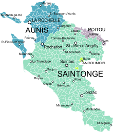
Previously a part of Saintonge and Aunis, Charente-Inférieure was one of the 83 original departments created during the French Revolution on 4 March 1790. On 4 September 1941, it was renamed Charente-Maritime.
When first created, the commune of Saintes was assigned as the prefecture of the department (Saintes had previously been the capital of Saintonge). This changed in 1810 when Napoléon passed an imperial decree which moved the prefecture to La Rochelle.
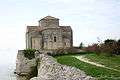
During World War II, the department was invaded by the German army and became part of occupied France. To provide defence against a possible beach landing, the Organisation Todt constructed a number of sea defences in the area. Defences such as pillboxes are particularly noticeable on the beaches of the presqu'île d'Arvert and the island of Oléron.
At the end of the war there were only two pockets of German resistance: La Rochelle, in the north and Royan in the south. Despite being almost completely destroyed during an RAF bombing raid on 5 January 1945, the town of Royan wasn't liberated by the French resistance until April of the same year. La Rochelle was finally captured on 9 May 1945.
Geography
Charente-Maritime is part of the Nouvelle-Aquitaine administrative region. It has a land area of 6864 km² and 628,733 inhabitants as of 2012.
The important rivers are the Charente and its tributaries, the Boutonne and the Seugne, along with the Sèvre Niortaise, the Seudre, and the Garonne, in its downstream part, which is the estuary of the Gironde.
The department includes the islands of Île de Ré, Île d'Aix, Ile d'Oléron, and Île Madame.
The department forms the northern part of the Aquitaine Basin. It is separated from the Massif Armoricain by the Marais Poitevin to the north-west and from the Parisian basin by the Seuil du Poitou to the north-east. The highest point in the department is in the woods of Chantemerlière, near the commune of Contré in the north-east, and rises to 173 m.
Charente-Maritime is surrounded by the departments of Gironde, Charente, Deux-Sèvres, Dordogne and Vendée.
Climate
The climate is mild and sunny, with less than 900 mm of precipitation per year and with insolation being remarkably high, in fact, the highest in Western France including southernmost sea resorts such as Biarritz. Average extreme temperatures vary from 38 °C (100 °F) in summer to−5 °C (23 °F) in winter.
Economy
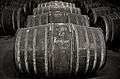
The economy of Charente-Maritime is based on three major sectors: tourism, maritime industry, and manufacturing. Cognac and pineau are two of the major agricultural products with maize, corn and sunflowers being the others.
During the summer months, families flock from all over Europe to bask in the sun and enjoy the local seafood.
Charente-Maritime is the headquarters of the major oyster producer Marennes-Oléron. Oysters cultivated here are shipped across Europe.
Rochefort is a shipbuilding site and has been a major French naval base since 1665.
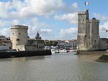
La Rochelle is a seat of major French industry. Just outside the city is a factory for the French engineering giant Alstom, where the TGV, the cars for the Paris and other metros are manufactured. It is a popular venue for tourism, with its picturesque medieval harbour and city walls.
Demographics
The inhabitants of the department are called Charentais-Maritimes.
Politics
The President of the General Council is Dominique Bussereau of the Union for a Popular Movement.
| Party | seats | |
|---|---|---|
| • | Union for a Popular Movement | 18 |
| Socialist Party | 15 | |
| • | Miscellaneous Right | 8 |
| Left Radical Party | 7 | |
| The Greens | 1 | |
| • | New Centre | 1 |
| MoDem | 1 | |
Tourism
Popular destinations include, La Rochelle, Royan, Saintes, St Jean d'Angely, Rochefort, Île d'Aix, Île de Ré and Île d'Oléron.
The department is served by the TGV at Surgères and La Rochelle. It can also be reached by motorway by the A10 (E5, Paris-Bordeaux) and A837 (E602, Saintes-Rochefort).
-
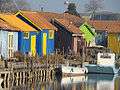
Oyster farms in the Oléron island

See also
- Cantons of the Charente-Maritime department
- Communes of the Charente-Maritime department
- Arrondissements of the Charente-Maritime department
- Éclade des Moules
External links
![]() "Charente-Inférieure". Encyclopædia Britannica. 5 (11th ed.). 1911.
"Charente-Inférieure". Encyclopædia Britannica. 5 (11th ed.). 1911.
- (French) Charente Maritime website
- (French) News Charente Maritime
- (English) Official Tourism Guide of Charente-Maritime
- (French) Official Tourism Guide of Charente-Maritime
- (French) Charente Maritime News
- (French) Zoo de la Palmyre
- (French) Ile d'Oléron
- (French) Ile de ré
- (French) Tourisme Ile de re