Chariot, Alaska
| Chariot | |
|---|---|
| Populated place | |
|
Aerial shot of Chariot, AK located near cape thompson. The once proposed sight of an artificial harbor created using chained nuclear explosions. | |
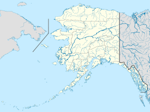 Chariot Location within the state of Alaska | |
| Coordinates: 68°6′21″N 165°44′34″W / 68.10583°N 165.74278°WCoordinates: 68°6′21″N 165°44′34″W / 68.10583°N 165.74278°W | |
| Country | United States |
| State | Alaska |
| Borough | North Slope |
| Time zone | Alaska (AKST) (UTC-9) |
| • Summer (DST) | AKDT (UTC-8) |
| GNIS feature ID | 1400155[1] |

.JPG)
Aerial shot of Chariot, AK located near cape thompson. The once proposed sight of an artificial harbor created using chained nuclear explosions.
Chariot is a populated area on the coast of the Chukchi Sea in the western part of North Slope Borough in the U.S. state of Alaska. It is located close to the mouth of Ogotoruk Creek in the Ogotoruk Valley, 10 km ESE of Cape Thompson, Arctic Slope. Maximum elevation 20 m.
The place was named around 1962 after Project Chariot by personnel of the project. The name likely refers to a headquarters building on the site.[1]
References
See also
Municipalities and communities of North Slope Borough, Alaska, United States | ||
|---|---|---|
| Cities | 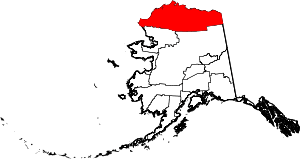 | |
| CDPs | ||
| Unincorporated communities | ||
| Ghost towns | ||
This article is issued from Wikipedia - version of the 11/10/2014. The text is available under the Creative Commons Attribution/Share Alike but additional terms may apply for the media files.