Checkpoint Bravo
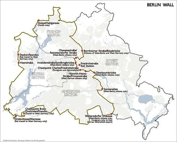
Checkpoint Bravo ("Checkpoint B") was the name given by the Western Allies to the main autobahn border crossing points between West Berlin and the German Democratic Republic It was known in German as Grenzübergangsstelle Drewitz-Dreilinden. Drewitz is a community nearby, and Dreilinden is the name of the wooded area in Berlin through which the highway passes. [1]
Geography
The checkpoint was located on the motorway A 115 (known within Berlin as the AVUS), between the Berliner locality of Nikolassee and the Brandenburger rural community of Drewitz, part of the municipality of Kleinmachnow.
History
The checkpoint was the nearest motorway border crossing point to the Helmstedt-Marienborn border crossing ("Checkpoint Alpha") on the border of West Germany, making it part of the shortest highway transit route between West Germany and West Berlin.
The checkpoint was shifted slightly during 1969 from Drewitz (part of Potsdam),[2] after the East German authorities realigned the transit route to eliminate a brief re-entry into GDR territory before transit traffic could finally enter West Berlin. The new checkpoint was relocated to Nikolassee (part of district Zehlendorf).
Since German reunification
The site of the original, pre-1969 checkpoint (rest stop, adjacent car park and abandoned highway) was used in filming the Alarm für Cobra 11 – Die Autobahnpolizei television series.[3] The site itself, "which includes a derelict bridge and a crumbling cafe covered in graffiti," was auctioned in September 2010 for €45,000.[4]
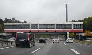
The vast site of the East-German checkpoint was eventually converted into a commercial park named Europarc Dreilinden (German).[5] All that remains of the checkpoint is the former main control tower that now houses a museum of the checkpoint.[6]
Gallery
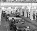 Congestion at the East German checkpoint in Drewitz in March 1972 after the temporary easing of travel restrictions into East Germany.
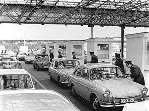 Congestion at the East German checkpoint in Drewitz in March 1972 after the temporary easing of travel restrictions into East Germany.
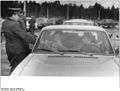 East German border guards checking vehicles at the checkpoint in Drewitz in March 1972 after the easing of travel restrictions into East Germany.
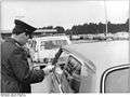 East German border guards checking vehicles at the checkpoint in Drewitz in March 1972 after the easing of travel restrictions into East Germany.
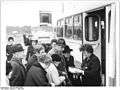 West Berlin passengers board buses to travel in East Germany at the Drewitz checkpoint in March 1972 after the temporary easing of travel restrictions into East Germany.
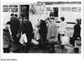 West Berlin passengers board buses to travel in East Germany at the Drewitz checkpoint in March 1972 after the temporary easing of travel restrictions into East Germany.
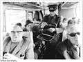 East German border guards check passes of West Berlin passengers in March 1972 after the temporary easing of travel restrictions into East Germany.
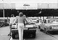 Transit traffic from West Germany waiting to enter West Berlin at the East German checkpoint at Drewitz in 1986. Drivers and passengers would push their cars to save fuel.
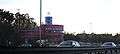 Former checkpoint in 2009.
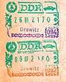 Passport stamps from the Drewitz checkpoint.
See also
References
- ↑ "Gesamtkonzept zur Erinnerung an die Berliner Mauer: Dokumentation, Information und Gedenken: 2.4.7. Checkpoint Bravo: Denkmalraum Dreilinden-Drewitz" (in German). City of Berlin. Retrieved 20 September 2010.
- ↑ Location of the old Checkpoint Bravo on Google Maps
- ↑ "Der Tagesspiegel: Berliner Grenzkontrollpunkt Dreilinden wird versteigert" (in German). Fair News. Retrieved 20 September 2010.
- ↑ Martin, Michelle (16 September 2010). "Mystery bidder buys Berlin's "Checkpoint Bravo"". Reuters. Retrieved 20 September 2010.
- ↑ Official Europark Dreilinden website
- ↑ Memorial site of Checkpoint Bravo (German)
- British Garrison Berlin 1945 -1994, "No where to go", W. Durie ISBN 978-3-86408-068-5
External links
| Wikimedia Commons has media related to Checkpoint Bravo. |
- Checkpoint Bravo official website (German)
| Main articles | 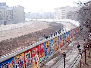 | |
|---|---|---|
| Memorials, museums and galleries | ||
| Crossings | ||
| Died breaching the Wall | ||
| Others associated with the Wall | ||
| The Wall in speeches | ||
| In popular culture |
| |
| Other | ||
| ||
Coordinates: 52°24′58.86″N 13°11′49.02″E / 52.4163500°N 13.1969500°E