Cherkasy Raion
Coordinates: 49°30′0″N 31°48′0″E / 49.50000°N 31.80000°E
| Cherkasy Raion Черкаський район | |||
|---|---|---|---|
| Raion | |||
| |||
 | |||
| Country |
| ||
| Region |
| ||
| Established | 4 January 1965 | ||
| Admin. center | Cherkasy | ||
| Subdivisions |
List
| ||
| Government | |||
| • Chairman | Kostiantyn Omargalieva | ||
| Area | |||
| • Total | 1,617 km2 (624 sq mi) | ||
| Population (2016) | |||
| • Total | 75,784 | ||
| • Density | 47/km2 (120/sq mi) | ||
| Time zone | EET (UTC+2) | ||
| • Summer (DST) | EEST (UTC+3) | ||
| Postal index | 19601—19646 | ||
| Area code | 380-472 | ||
| Website | http://cherkassy-rda.gov.ua/ | ||

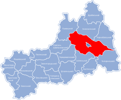
Cherkasy Raion (Ukrainian: Черкаський район, translit.: Cherkas'kyi raion) is an administrative part of Cherkasy Oblast. The center of the raion is Cherkasy. The area of the raion is 1,617 km2 (624 sq mi), with density of 49 inhabitants per square kilometre (130/sq mi). The population consists of Ukrainians (96.4%), Russians (2.9%), Belorussians (0.2%), and others (0.5%). The population was 75,784 (2016 est.)[1]. There are 39 settlements on the territory of the district - 38 villages and 1 urban-type settlement - Irdyn.
It is located in the Eastern part of Cherkasy oblast. Its approximate length is 76 km (47 mi) and its width is up to 25 km (16 mi). It is located on lowlands, on the bank of Kremenchuk Reservoir, on Dnipro River. Rivers, such as Ros, Vilshyanka, and Tyasmyn are passing through the raion. Forests cover about 62 hectares of the district, including the famous Cherkaskiy Bir (Cherkasy Forest).[2]
The raion consists of 39 settlements. There are 23 village councils (sil's'ka rada) in Cherkasy raion. The biggest villages of the district are Ruska Polyana (Ukrainian: Руська Поляна), Chervona Sloboda (Ukrainian: Червона Слобода), Bilozirya (Ukrainian: Білозір'я), and Moshny (Ukrainian: Мошни).
The district is crossed with highways which connect Cherkasy with other cities like Kaniv, Zolotonosha, Uman. The length of all routes is 3,209 km (1,994 mi), from which 1,012 km (629 mi) are national routes. The region also hosts a part of Odessa-Moscow railway route.
Since January 2015, the chairman of the district administration has been Kostiantyn Omargaliev.[3]
References
- ↑ "Чисельність наявного населення України (Actual population of Ukraine)" (PDF) (in Ukrainian). State Statistics Service of Ukraine. Retrieved 19 July 2016.
- ↑ "Черкаський район" [Cherkasy Raion] (in Ukrainian). Cherkasy Regional State Administration. Archived from the original on 23 March 2014. Retrieved 10 August 2016.
- ↑ "ПЕТРО ПОРОШЕНКО ПРИЗНАЧИВ ГОЛОВОЮ ЧЕРКАСЬКОЇ РДА КОСТЯНТИНА ОМАРГАЛІЄВА" [Poroshenko appointes Kostiantyn Omargalieva head of Cherkasy RDA] (in Ukrainian). Cherkasy District State Administration. 19 January 2015. Archived from the original on 10 August 2016. Retrieved 10 August 2016.
| Wikimedia Commons has media related to Cherkasy Raion. |
| Raions | |||||||
|---|---|---|---|---|---|---|---|
| Cities |
| ||||||
| |||||||