Christianshavns Vold
| Christianshavns Vold | |
|---|---|
|
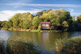
A house on the Christiania portion of the rampart | |
| Type | Public park and historic site |
| Location | Christianshavn, Copenhagen |
| Coordinates | 55°40′25″N 12°36′13″E / 55.6735°N 12.6035°ECoordinates: 55°40′25″N 12°36′13″E / 55.6735°N 12.6035°E |
| Area |
Land: 12 ha/Water: 19 ha[1] + Christiania portion |
| Created | 1918–25 |
Christianshavns Vold is a former rampart which was part of the bastioned fortification ring which used to surround Copenhagen, Denmark. Running along the full south-eastern perimeter of Christianshavn and Holmen, it used to form a protective barrier towards the island of Amager. It consists of earthworks with 12 bastions and in front of it ran a moat, Stadsgraven, now forming a broad canal which separates Christianshavn from the rest of Amager. Along with Kastellet on the other side of the harbour, it is the only intact part of the fortification system.
Today Christianshavns Vold serves as an important greenspace for Christianshavn's inhabitants. The southern half of the rampart is a municipal park whereas the northern portion is part of Freetown Christiania, a self-built, semi-autonomous community which has existed since the early 1970s. Part of Christiania is located on the far side of Stadsgraven and the two halves are connected by the Dyssebroen footbridge.
History
As part of his endeavour to modernize Copenhagen's fortifications, Christian IV constructed Christianshavn as a fortified merchant's town at a shallow-watered, marshy area north of Amager to complete a fortification ring around Copenhagen. The town was laid out with low earthworks facing Amager. The rampart was constructed with four and a half bastions and a city gate, known as Amagerport, through which all traffic to and from Amager had to pass.[2]
.jpg)
In the 1670s, when Vestervold was extended to reach the sea, Christiansvold was moved and extended to match the new course of Vestervold. Only the two northernmost bastions, today known as Løvens Bastion and Elefantens Bastion, remained on their original location. The new Christianshavns Vold had 5 very large bastions. Around the entire complex was a moat with a protecting counterscarp. From 1682-92 Christianshavns Vold was again extended this time in northwards, to guard the entrance to the harbour and protect the new base for the Royal Fleet at what was to become known as Nyholm. The extension included 7 new bastions, named for members of the Royal family. The last extension of Christianshavns Vold was constructed as late as 1878-82, when a rampart was constructed along the eastside of the newly reclaimed Refshaleø.
Bastions
- Quintus Bastion
- Charlotte Amalies Bastion
- Frederiks Bastion, with gunpowder magazine
- Carls Bastion, with a gunpowder magazine
- Vilhelms Bastion
- Sofie Hedevig Bastion
- Ulriks Bastion
- Løvens Bastion, with the remains of a windmill
- Elefantens Bastion
- Panterens Bastion
- Enhjørning Bastion
- Kalvebod Bastion
Christianshavns Vold today
Christianshavns Vold generally remains well-preserved as a historic site. Torvegade, the main thoroughfare of Christianshavn, running from Knippels Bridge to the dam to Amager, passes between Løvens Bastion and Elefantens Bastion at the site where Amagerport used to lie. The grounds serve as a public park, part of the city's Fortification Ring park band. The windmill on Løvens Bastion, Lille Mølle which was converted into a private home in 1917, has been converted into a historic house museum.[3]
The northern part of the rampart is today part of Freetown Christiania. The two former gunpowder magazines at Frederiks and Carls Bastions serve as venues for small concerts and art exhibitions.[4]
See also
- Fortifications of Copenhagen (17th century)
- Fortification Ring, Copenhagen
- Parks and open spaces in Copenhagen
References
- ↑ "Fakta/historie". Københavns Kommune. Retrieved 2010-07-03.
- ↑ "De bastionære fæstninger 1600-1870". Selskabet for Københavns Historie. Retrieved 2009-11-17.
- ↑ "Løvens Bastion". Christianshavns Lokalhistoriske Forening & Arkiv. Retrieved 2009-11-17.
- ↑ "Christianshavn". Wonderful Copenhagen. Retrieved 2009-11-17.