Chuzhou
| Chuzhou 滁州市 | |
|---|---|
| Prefecture-level city | |
|
| |
.png) Location of Chuzhou City jurisdiction in Anhui | |
| Country |
|
| Province | Anhui |
| County-level divisions | 8 |
| Township-level divisions | 178 |
| Municipal seat |
Langya District (32°18′N 118°18′E / 32.300°N 118.300°E) |
| Government | |
| • Mayor | Zhang Xiangan(张祥安) |
| Area | |
| • Prefecture-level city | 13,523.21 km2 (5,221.34 sq mi) |
| • Urban | 1,404.3 km2 (542.2 sq mi) |
| • Metro | 1,404.3 km2 (542.2 sq mi) |
| Population (2010 Census) | |
| • Prefecture-level city | 3,937,868[1] |
| • Urban | 562,321 |
| • Urban density | 400/km2 (1,000/sq mi) |
| • Metro | 562,321 |
| • Metro density | 400/km2 (1,000/sq mi) |
| Time zone | China Standard (UTC+8) |
| Postal code | 239000 |
| Area code(s) | 0550 |
| License Plate Prefix | 皖M |
Chuzhou (Chinese: 滁州; pinyin: Chúzhōu) is a prefecture-level city in eastern Anhui Province, China. It borders the provincial capital of Hefei to the southwest, Huainan to the west, Bengbu to the northwest, Chaohu to the south, and the province of Jiangsu to the east. According to the 2010 Census, the city of Chuzhou has a registered population of 3,937,868 inhabitants, whom 562,321 lived in the built-up (or metro) area made of 2 urban districts.[2] Nevertheless, 7,260,240 persons declared to be permanent residents.[3]
Climate
Chuzhou has a monsoon-influenced, humid subtropical climate (Köppen Cfa), with four distinct seasons. Winters are cold and damp, with average low temperatures in January dipping just below freezing; the January 24-hour average temperature is 2.3 °C (36.1 °F). Summers are typically hot and humid, with a July average of 27.6 °C (81.7 °F). The annual mean is 15.42 °C (59.8 °F), while annual precipitation averages 1,054 millimetres (41 in), a majority of which occurs from May to August.
| Climate data for Chuzhou (1971−2000) | |||||||||||||
|---|---|---|---|---|---|---|---|---|---|---|---|---|---|
| Month | Jan | Feb | Mar | Apr | May | Jun | Jul | Aug | Sep | Oct | Nov | Dec | Year |
| Record high °C (°F) | 20.7 (69.3) |
26.4 (79.5) |
28.7 (83.7) |
32.8 (91) |
36.0 (96.8) |
37.5 (99.5) |
38.7 (101.7) |
38.3 (100.9) |
38.6 (101.5) |
34.1 (93.4) |
28.8 (83.8) |
22.1 (71.8) |
38.7 (101.7) |
| Average high °C (°F) | 6.6 (43.9) |
8.5 (47.3) |
13.1 (55.6) |
20.2 (68.4) |
25.6 (78.1) |
28.7 (83.7) |
31.5 (88.7) |
31.5 (88.7) |
27.1 (80.8) |
22.0 (71.6) |
15.6 (60.1) |
9.6 (49.3) |
20.0 (68) |
| Daily mean °C (°F) | 2.3 (36.1) |
4.1 (39.4) |
8.6 (47.5) |
15.3 (59.5) |
20.6 (69.1) |
24.4 (75.9) |
27.6 (81.7) |
27.2 (81) |
22.6 (72.7) |
17.1 (62.8) |
10.5 (50.9) |
4.7 (40.5) |
15.4 (59.7) |
| Average low °C (°F) | −1.2 (29.8) |
0.6 (33.1) |
4.6 (40.3) |
10.7 (51.3) |
16.1 (61) |
20.7 (69.3) |
24.3 (75.7) |
23.9 (75) |
19.1 (66.4) |
13.1 (55.6) |
6.4 (43.5) |
0.8 (33.4) |
11.6 (52.9) |
| Record low °C (°F) | −13 (9) |
−11.8 (10.8) |
−5.7 (21.7) |
0.2 (32.4) |
6.9 (44.4) |
12.7 (54.9) |
17.1 (62.8) |
17.4 (63.3) |
9.1 (48.4) |
1.5 (34.7) |
−6.7 (19.9) |
−12.3 (9.9) |
−13 (9) |
| Average precipitation mm (inches) | 35.6 (1.402) |
46.5 (1.831) |
78.1 (3.075) |
71.3 (2.807) |
86.3 (3.398) |
176.3 (6.941) |
207.5 (8.169) |
128.4 (5.055) |
83.0 (3.268) |
61.9 (2.437) |
55.4 (2.181) |
24.3 (0.957) |
1,054.6 (41.521) |
| Average precipitation days (≥ 0.1 mm) | 7.7 | 8.3 | 11.6 | 9.7 | 10.1 | 11.8 | 13.0 | 10.9 | 8.9 | 8.3 | 7.0 | 5.2 | 112.5 |
| Source: Weather China | |||||||||||||
Administration
The prefecture-level city of Chuzhou administers 8 county-level divisions, including 2 districts, a sub-prefecture-level city (Tianchang), a county-level city and 4 counties. The population information here presented uses 2010 census data of permanent residents.
| # | English Name | Chinese | Pinyin | Area | Population | Density |
|---|---|---|---|---|---|---|
| 1 | Langya District | 琅琊区 | Lángyá Qū | 181 | 310,427 | 1,715 |
| 2 | Nanqiao District | 南谯区 | Nánqiáo Qū | 1,187 | 251,894 | 212 |
| 4 | Tianchang City | 天长市 | Tiāncháng Shì | 1,770 | 602,840 | 341 |
| 3 | Mingguang City | 明光市 | Míngguāng Shì | 2,335 | 532,732 | 228 |
| 5 | Lai'an County | 来安县 | Lái'ān Xiàn | 1,481 | 432,021 | 292 |
| 6 | Quanjiao County | 全椒县 | Quánjiāo Xiàn | 1,572 | 383,885 | 244 |
| 7 | Dingyuan County | 定远县 | Dìngyuǎn Xiàn | 2,998 | 779,174 | 260 |
| 8 | Fengyang County | 凤阳县 | Fèngyáng Xiàn | 1,950 | 644,895 | 331 |
| Map |
|---|
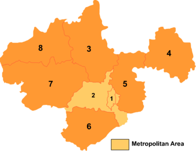 |
These are further divided into 178 township-level divisions, including 86 towns, 78 townships and 14 subdistricts.
Tourism
Langya temple and the Deep Elegant Lake, located nearby, are popular tourist destinations.
Education
- Chuzhou University (CZHU, 滁州学院)
- Chuzhou Radio and TV University
Notable people
- Zhu Yuanzhang (1328–1398), founding emperor of the Ming Dynasty
- Wu Jingzi (1701–1754), Qing Dynasty writer, author of The Scholars
- Jiang Shan (born 1962), former Communist Party Secretary of the city, dismissed for corruption
References
External links
- Government website of Chuzhou (in Simplified Chinese)
- Map of chuzhou