City of Heidelberg
| City of Heidelberg Victoria | |||||||||||||
|---|---|---|---|---|---|---|---|---|---|---|---|---|---|
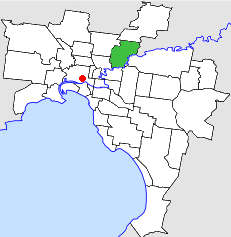 Location in Melbourne | |||||||||||||
 Heidelberg Town Hall | |||||||||||||
| Population | 62,800 (1992)[1] | ||||||||||||
| • Density | 1,842.7/km2 (4,773/sq mi) | ||||||||||||
| Established | 1840 | ||||||||||||
| Area | 34.08 km2 (13.2 sq mi) | ||||||||||||
| Council seat | Ivanhoe | ||||||||||||
| Region | Melbourne | ||||||||||||
| County | Bourke | ||||||||||||
 | |||||||||||||
The City of Heidelberg was a local government area about 10 kilometres (6 mi) northeast of Melbourne, the state capital of Victoria, Australia. The city covered an area of 34.08 square kilometres (13.16 sq mi), and existed from 1840 until 1994.
History
Heidelberg was first incorporated as a trust in 1840, making it one of the earliest local government formations in Australia. On 12 October 1860 it became a road district, administered by a Roads Board. It became a shire on 27 January 1871 and was proclaimed a city on 11 April 1934. In the 1960s it lost significant sections of its territory; on 1 October 1962, the neighbouring City of Northcote annexed its South Ward, and on 30 September 1964, the Shire of Diamond Valley was created out of its mostly rural North Ward.[2]
On 15 December 1994, the City of Heidelberg was abolished, and, along with parts of the Shires of Diamond Valley and Eltham, was merged into the newly City of Banyule. A small area near La Trobe University was transferred to the City of Darebin.[3]
Council meetings were held at the Heidelberg Town Hall, on Upper Heidelberg Road, Ivanhoe. It is still used for the same purpose by the City of Banyule.
Wards
The City of Heidelberg was subdivided into five wards, each electing three councillors:
- Banyule Ward
- Eaglemont Ward
- Heidelberg West Ward
- Ivanhoe Ward
- Macleod Ward[2]
Suburbs
- Bellfield
- Eaglemont
- Heidelberg
- Heidelberg Heights
- Heidelberg West
- Ivanhoe
- Ivanhoe East
- Macleod (shared with the Shire of Diamond Valley)
- Rosanna
- Viewbank
- Yallambie
Population
| Year | Population |
|---|---|
| 1954 | 60,007 |
| 1958 | 77,000*+ |
| 1961 | 59,795 |
| 1966 | 63,810 |
| 1971 | 68,013 |
| 1976 | 66,108 |
| 1981 | 64,757 |
| 1986 | 62,717 |
| 1991 | 60,468 |
| 2011 | 118,305 |
* Estimate in the 1958 Victorian Year Book.
+ Includes the two sections severed in 1962-1964.
References
- ↑ Australian Bureau of Statistics, Victoria Office (1994). Victorian Year Book. p. 49. ISSN 0067-1223.
- 1 2 Victorian Municipal Directory. Brunswick: Arnall & Jackson. 1992. pp. 397–398. Accessed at State Library of Victoria, La Trobe Reading Room.
- ↑ Australian Bureau of Statistics (1 August 1995). Victorian local government amalgamations 1994-1995: Changes to the Australian Standard Geographical Classification (PDF). Commonwealth of Australia. pp. 4–5. ISBN 0-642-23117-6. Retrieved 2007-12-16.
Coordinates: 37°46′S 145°03′E / 37.767°S 145.050°E