Claremorris
| Claremorris Clár Chlainne Mhuiris | |
|---|---|
| Town | |
 | |
 Claremorris Location in Ireland | |
| Coordinates: 53°43′01″N 8°59′54″W / 53.7169°N 8.99833°WCoordinates: 53°43′01″N 8°59′54″W / 53.7169°N 8.99833°W | |
| Country | Republic of Ireland |
| Province | Connacht |
| County | County Mayo |
| Elevation | 73 m (240 ft) |
| Population (2011) | |
| • Total | 3,979 |
| Irish Grid Reference | M338751 |
| Historical population | ||
|---|---|---|
| Year | Pop. | ±% |
| 1821 | 1,297 | — |
| 1831 | 1,476 | +13.8% |
| 1841 | 2,256 | +52.8% |
| 1851 | 1,560 | −30.9% |
| 1861 | 1,323 | −15.2% |
| 1871 | 1,103 | −16.6% |
| 1881 | 1,319 | +19.6% |
| 1891 | 1,259 | −4.5% |
| 1901 | 1,118 | −11.2% |
| 1911 | 1,069 | −4.4% |
| 1926 | 1,107 | +3.6% |
| 1936 | 1,132 | +2.3% |
| 1946 | 1,045 | −7.7% |
| 1951 | 1,063 | +1.7% |
| 1956 | 1,512 | +42.2% |
| 1961 | 1,519 | +0.5% |
| 1966 | 1,479 | −2.6% |
| 1971 | 1,718 | +16.2% |
| 1981 | 2,036 | +18.5% |
| 1986 | 1,992 | −2.2% |
| 1991 | 1,907 | −4.3% |
| 1996 | 1,914 | +0.4% |
| 2002 | 2,101 | +9.8% |
| 2006 | 2,595 | +23.5% |
| 2011 | 3,979 | +53.3% |
| 2016 | 4,487 | +12.8% |
| [1][2][3] | ||
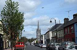
Claremorris (Irish: Clár Chlainne Mhuiris) is a town in County Mayo in the west of Ireland, at the junction of the N17 and the N60 national routes. The population of Claremorris in the 2011 Census was 3,979.[4]
The town sits at the bottom of a valley, all roads leading to the town follow hills, in particular the old Knock road (known as the Knock hill) and Courthouse road. Although low-lying, the town does not experience flooding. There is no major river through the town.
Claremorris is the fastest growing town in County Mayo. There was a 31% increase in the town's population between 2006 and 2011 and a 23% increase between 2002 and 2006.
History
The town derived its name from Maurice de Prendergast, a Norman who came to Ireland in 1169.
The town was established during the 18th century. In 1822 the Roman Catholic Chapel was built, which was later demolished to make way for the town hall. The present Roman Catholic Church St Colman's Church, was built in 1911. St. John's Anglican Church, now the town library, was built in 1828.
The main landlord family in Claremorris was the Browne family, one of whom, the Hon. Denis Browne (1760-1828), was High Sheriff of Mayo during the Irish Rebellion of 1798 and acquired the nickname of "Donnchadha an Ropa" (Denis the Rope) as a result of his treatment of captured rebels, who had also burnt down his house. He was afterwards MP for Mayo in the UK Parliament.
Demographics
In April 2011, Claremorris had a total population of 3,412 people, consisting of 1,577 males and 1,835 females. 23.1% percent of the population were non-Irish nationals and 96.1% of the resident population had lived at the same address the year before. There were 2,945 Roman Catholics in the area at the time of census making it the largest religion in the area.[5]
Amenities
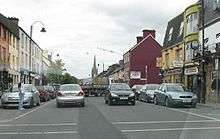
Many new shops have been added in the last few years, including The Silverbridge Shopping Centre. With the development of Chapel Lane from a derelict street to a commercial street, this part of the town has been transformed. Four supermarkets compete for customers in the town including retail giants Tesco and Aldi.
There are three hotels including the modern 4-star McWilliam Park Hotel, which opened in late 2006. It has a leisure centre, swimming pool and conference facilities. The town has several restaurants catering for Italian, Indian, Chinese and Irish cuisine.
Claremorris has many pubs, however a number have closed down in recent years. The town has two nightclubs namely Rumours and Diceys.
A swimming pool and leisure centre opened on 1 September 2009. A new Garda Station opened in 2008. A new 6-screen cinema has been planned.
There are two secondary schools - St Colman's College for boys and Mount St. Michael for girls - and several primary schools.
The surrounding countryside is of rolling drumlins, eskers, woods and lakes.
Genealogical records for Claremorris consist of Roman Catholic church records of marriage which commenced in 1805 and baptisms which commenced in 1825. Church of Ireland records consist of baptisms from 1834 onwards, marriages from 1846 onwards and burials from 1878 onwards. These are held at the South Mayo Family Research Centre in Ballinrobe.
Sports
There are a number of sporting clubs including:
- Claremorris GAA, train at many pitches in the town, and compete at many levels from under-10s up to senior in both Men's & Ladies' Competitions. They have been County Mayo senior hurling champions twice: 1968, and 1971 and senior county Gaelic football champions four times: 1961, 1964, 1965 and 1971.
- The Swimming Club train at the all-new, ultra-modern Claremorris Leisure Centre. The swimming club incorporates water polo. In recent years the team became the first club from Connacht to win the all-Ireland under 16 & under 19 Boys championships, as well as being the first club to win the inaugural Girls Under-16 & Under-19 Championships.
- The new Claremorris Leisure Centre opened on 1 September 2009. It has a 25-metre, 6 lane, short course competition pool. It also incorporates a large gymnasium & fitness studio. It offers a wide variety of fitness classes.[6]
- The Soccer Club, which trains & plays their matches at Concannon park. Derek Glynn began his career playing for Claremorris.
- The Golf club play at the local 18-hole course located just outside Claremorris on the Galway Road
- The Athletics Club train on a newly developed mondo athletics track.
- The Tennis Club courts at the centre of town are the most modern in Mayo.
- Claremorris Colts RFC was established in 2009 and runs mini rugby for boys and girls aged from 7– 12 years old each Saturday morning from September to March at the Mount St Michael Convent Girls School pitch. The club also has teams in u13, u14, u15 and u16 age grades who compete in the Connacht Branch league and cup competitions. In April 2012 Claremorris Colts RFC was awarded the title of 'Club of the Year 2012' by the Connacht Branch of the IRFU.
- Boxercise is also available with Burn It With Diane Studio in Lakeside retail park
Transport
.jpg)
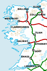
Road
Claremorris is situated at a major road junction. The N17 (Galway-Sligo road) and the N60 (Castlebar-Roscommon road) meet in the town.
The town was once a major traffic bottleneck.
Claremorris ground to a halt every afternoon, (particularly Fridays), when the busy N17 slowly negotiated the old bank corner which consisted of a sharp right hand bend. By the late 1990s, over 13,000 vehicles were trundling through the town daily.
In 1994 a design for the bypass was completed by Mayo County Council, the CPO went ahead in 1995. Followed by a 3-year wait for funding allocation for the scheme. Eventually in 1998 the go ahead was given and construction of the bypass commenced. The N17 bypass opened in July 2001 to the relief of thousands of motorists. Journey times at peak periods were reduced by 30 minutes on the Galway/Sligo route after the opening. The project was built as a grade separated single carriageway (motorway style interchanges) which is unusual for single carriageway bypasses in Ireland. The new 16 km road bypassed one of Irelands most treacherous national routes, the original 7 mile stretch between Claremorris and Knock had a very high accident rate due to its poor alignment. The busy N60 still passes through the town via an inner relief road. A second bypass for the town is included in the proposed new N60 road to Castlebar, in 2011 the NRA suspended this road development due to government cutbacks.
Railways
Claremorris railway station is served by the Dublin Galway/Westport line as well as the Ballina Branch Line to Ballina. There is currently a campaign underway to open the Western Railway Corridor through Claremorris linking Limerick to Sligo. The Claremorris-Tuam phase was due to open in 2014 but is indefinitely postponed.
Weather station
Claremorris is home to one of Ireland's eight inland weather observing stations, located 2 kilometres from the town centre. It began recording weather in November 1943 and was run and staffed by a local family. During WWII Ireland provided detailed weather reports to the Allies. Weather reports from Claremorris and Blacksod Lighthouse (located on the west coast of Mayo) played a significant factor in selecting the date of launch for the invasion of France (D Day) on 6 June 1944. Many will remember the weather expert in the film "The Longest Day", imparting this information to Gen. Eisenhower and the Joint Chiefs of Staff. In 1949 it was decided that the Irish Meteorological Service needed observations on an hourly basis from inland stations like Claremorris. It was decided to staff the station with full-time permanent personnel. In 1996 staff were relocated to Knock airport and it now operates automatically with data uploaded to Dublin .[7]
Climate
Claremorris has a temperate oceanic climate with cold winters and warm damp summers. The coldest months being January and February and the wettest being December and October. Claremorris received roughly 1,500 hours of sunshine in 2010. Climate in this area has mild differences between highs and lows, and there is adequate rainfall year round. The Köppen Climate Classification subtype for this climate is "Cfb" (Marine West Coast Climate/Oceanic climate).[8]
| Climate data for Claremorris (1971-2000, extremes 1943–present) | |||||||||||||
|---|---|---|---|---|---|---|---|---|---|---|---|---|---|
| Month | Jan | Feb | Mar | Apr | May | Jun | Jul | Aug | Sep | Oct | Nov | Dec | Year |
| Record high °C (°F) | 15.7 (60.3) |
13.8 (56.8) |
20.1 (68.2) |
22.5 (72.5) |
25.4 (77.7) |
29.8 (85.6) |
30.5 (86.9) |
29.5 (85.1) |
25.1 (77.2) |
21.7 (71.1) |
16.1 (61) |
15.7 (60.3) |
30.5 (86.9) |
| Average high °C (°F) | 7.5 (45.5) |
8.1 (46.6) |
9.8 (49.6) |
12.1 (53.8) |
14.9 (58.8) |
17.0 (62.6) |
18.9 (66) |
18.7 (65.7) |
16.4 (61.5) |
13.1 (55.6) |
9.9 (49.8) |
8.1 (46.6) |
12.9 (55.2) |
| Daily mean °C (°F) | 4.6 (40.3) |
4.9 (40.8) |
6.3 (43.3) |
8.0 (46.4) |
10.5 (50.9) |
12.9 (55.2) |
15.0 (59) |
14.7 (58.5) |
12.5 (54.5) |
9.8 (49.6) |
6.7 (44.1) |
5.3 (41.5) |
9.3 (48.7) |
| Average low °C (°F) | 1.7 (35.1) |
1.8 (35.2) |
2.9 (37.2) |
3.9 (39) |
6.1 (43) |
8.8 (47.8) |
11.0 (51.8) |
10.6 (51.1) |
8.6 (47.5) |
6.4 (43.5) |
3.5 (38.3) |
2.5 (36.5) |
5.7 (42.3) |
| Record low °C (°F) | −15.7 (3.7) |
−17.1 (1.2) |
−12.1 (10.2) |
−5.5 (22.1) |
−3.1 (26.4) |
−0.4 (31.3) |
0.6 (33.1) |
1.1 (34) |
−1.2 (29.8) |
−4.5 (23.9) |
−6.4 (20.5) |
−15.0 (5) |
−17.1 (1.2) |
| Average precipitation mm (inches) | 127.9 (5.035) |
102.1 (4.02) |
101.6 (4) |
63.7 (2.508) |
68.1 (2.681) |
64.5 (2.539) |
70.1 (2.76) |
95.7 (3.768) |
94.3 (3.713) |
128.2 (5.047) |
127.7 (5.028) |
129.6 (5.102) |
1,173.6 (46.205) |
| Average precipitation days (≥ 0.2 mm) | 21 | 18 | 21 | 16 | 16 | 15 | 17 | 18 | 18 | 21 | 21 | 22 | 224 |
| Average snowy days | 5.7 | 4.4 | 3.8 | 1.6 | 0.2 | 0.0 | 0.0 | 0.0 | 0.0 | 0.1 | 1.2 | 3.1 | 20.0 |
| Average relative humidity (%) (at 15:00 LST) | 85.6 | 79.8 | 75.7 | 67.9 | 68.0 | 71.1 | 73.2 | 73.4 | 74.7 | 80.2 | 84.4 | 88.1 | 76.8 |
| Mean monthly sunshine hours | 40.3 | 53.7 | 80.6 | 129.0 | 155.0 | 132.0 | 114.7 | 117.8 | 96.0 | 74.4 | 51.0 | 27.9 | 1,072.4 |
| Mean daily sunshine hours | 1.3 | 1.9 | 2.6 | 4.3 | 5.0 | 4.4 | 3.7 | 3.8 | 3.2 | 2.4 | 1.7 | 0.9 | 2.9 |
| Source: Met Éireann[9][10][11] | |||||||||||||
People
Claremorris is the birthplace of:
- Lucinda Creighton TD, Minister of State for European Affairs
- Cardinal John D'Alton, Cardinal Archbishop of Armagh & Primate of All Ireland, 1946–1963
- Derek Glynn, Irish Soccer Player (striker)
- Sir John Gray, physician, surgeon, journalist, newspaper proprietor, and MP for Kilkenny City
- John Hegarty, 44th Provost of Trinity College, Dublin
- Delia Murphy, Singer and collector of Irish Ballads. Known as the "Queen Of Connemara".
- Catherine Noone, Fine Gael Senator
- Seamus O'Malley, who captained Mayo to their first All Ireland Senior Football Championship in 1936
- Pat Rabbitte TD, Minister for Communications, Energy & Natural Resources
- Michael Commins, Journalist and Radio Presenter
- Patrick Cassidy orchestral, choral, and film score composer
Local schools
- St. Colman's College, boys' secondary school.
- Mount St. Michael, girls' secondary school.
Local events
- The Claremorris Open Exhibition is an annual arts exhibition in the town held since 1978.
See also
External links
| Wikimedia Commons has media related to Claremorris. |
- Claremorris Chamber of Commerce
- Claremorris
- Claremorris, The Heart of the West
- Claremorris Golf Club
- West=on=Track
- Claremorris Community Radio
- Claremorris Colts Rugby Football Club
- Claremorris Workhouse
References
- ↑ "Archived copy". Archived from the original on 17 February 2012. Retrieved 2013-03-24.
- ↑ Lee, JJ (1981). "On the accuracy of the Pre-famine Irish censuses". In Goldstrom, J. M.; Clarkson, L. A. Irish Population, Economy, and Society: Essays in Honour of the Late K. H. Connell. Oxford, England: Clarendon Press.
- ↑ Mokyr, Joel; O Grada, Cormac (November 1984). "New Developments in Irish Population History, 1700-1850". The Economic History Review. 37 (4): 473–488. doi:10.1111/j.1468-0289.1984.tb00344.x.
- ↑ Actual and percentage change in population 2006 to 2011 by Province County City Urban area Rural area and Electoral division by District, Year and Statistic Central Statistics Office. Retrieved: 2011-11-27.
- ↑ http://census.cso.ie/areaprofiles/PDF/ST/claremorris.pdf
- ↑ Claremorris Leisure Centre
- ↑ "Met Éireann". Claremorris History.
- ↑ Climate Summary for Claremorris
- ↑ "Claremorris 1971–2000 averages". Met Éireann. Retrieved 27 May 2015.
- ↑ "Absolute Maximum Air Temperatures for each Month at Selected Stations" (PDF). Met Éireann. Retrieved 27 May 2015.
- ↑ "Absolute Minimum Air Temperatures for each Month at Selected Stations" (PDF). Met Éireann. Retrieved 27 May 2015.
- The Gray Family of Claremorris, Co. Mayo, Thomas Ormsby Ruttledge, in The Irish Genealogist 7, 1989