Clarendon Municipal Airport
| Clarendon Municipal Airport | |||||||||||
|---|---|---|---|---|---|---|---|---|---|---|---|
 | |||||||||||
| IATA: none – ICAO: none – FAA LID: 4M8 | |||||||||||
| Summary | |||||||||||
| Airport type | Public | ||||||||||
| Owner | City of Clarendon | ||||||||||
| Serves | Clarendon, Arkansas | ||||||||||
| Elevation AMSL | 217 ft / 66 m | ||||||||||
| Coordinates | 34°38′48″N 091°23′41″W / 34.64667°N 91.39472°WCoordinates: 34°38′48″N 091°23′41″W / 34.64667°N 91.39472°W | ||||||||||
| Map | |||||||||||
 4M8 Location of airport in Arkansas | |||||||||||
| Runways | |||||||||||
| |||||||||||
| Statistics (2012) | |||||||||||
| |||||||||||
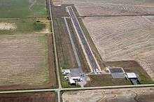
Clarendon Municipal Airport (FAA LID: 4M8) is a city owned, public use airport located five nautical miles (6 mi, 9 km) southwest of the central business district of Clarendon, a city in Monroe County, Arkansas, United States.[1] It is included in the National Plan of Integrated Airport Systems for 2011–2015, which categorized it as a general aviation facility.[2]
Facilities and aircraft
Clarendon Municipal Airport covers an area of 160 acres (65 ha) at an elevation of 217 feet (66 m) above mean sea level. It has one runway designated 18/36 with an asphalt surface measuring 3,200 by 60 feet (975 x 18 m).[1]
For the 12-month period ending August 31, 2012, the airport had 26,500 aircraft operations, an average of 72 per day: 98% general aviation and 2% military. At that time there were four single-engine aircraft based at this airport.[1]
References
- 1 2 3 4 FAA Airport Master Record for 4M8 (Form 5010 PDF). Federal Aviation Administration. Effective November 15, 2012.
- ↑ "2011–2015 NPIAS Report, Appendix A" (PDF). National Plan of Integrated Airport Systems. Federal Aviation Administration. October 4, 2010. Archived from the original (PDF, 2.03 MB) on 2012-09-27. External link in
|work=(help)
External links
- Clarendon Municipal (4M8) at Arkansas Department of Aeronautics
- Aerial image as of March 1994 from USGS The National Map
- Airfield photos from U.S. Civil Air Patrol at the Wayback Machine (archived September 23, 2006)
- Resources for this airport:
- FAA airport information for 4M8
- AirNav airport information for 4M8
- FlightAware airport information and live flight tracker
- SkyVector aeronautical chart for 4M8