Geography of Bahrain
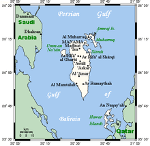
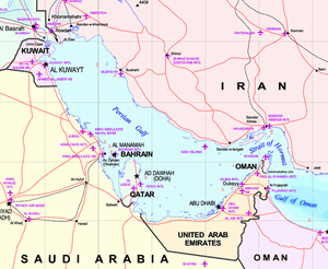
The Kingdom of Bahrain[n 1] consists of Bahrain Island and 33 of the 37 Bahrain Islands, lying in the Persian Gulf's Gulf of Bahrain off the north shore of Asia's Arabian Peninsula. Bahrain's capital city is Manama. The islands are about 24 kilometers (15 mi) off the east coast of Saudi Arabia and 28 kilometers (17 mi) from Qatar. The total area of the country is about 780 square kilometers (301 sq mi), about 3.5 times the size of the District of Columbia.
Bahrain Island accounts for about 83% of the kingdom's land area, comprising 590 square kilometers (228 sq mi). It is 48 kilometers (30 mi) long from north to south and at its widest point stretches 16 kilometers (10 mi) from east to west.
The island is surrounded by several of the Middle East's large petroleum fields and commands a strategic position amid the Persian Gulf's shipping lanes.
Geographical setting and islands
Following the return of Janan to Qatar in March 2001, that state of Bahrain consists of 33 natural islands in the Bahrain Islands archipelago.
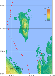
Around most of Bahrain is a relatively shallow inlet of the Persian Gulf known as the Gulf of Bahrain. The seabed adjacent to Bahrain is rocky and, mainly off the northern part of the island, covered by extensive coral reefs. Most of the island is low-lying and barren desert. Outcroppings of limestone form low rolling hills, stubby cliffs, and shallow ravines. The limestone is covered by various densities of saline sand, capable of supporting only the hardiest desert vegetation – chiefly thorn trees and scrub. There is a fertile strip five kilometers wide along the northern coast on which date, almond, fig, and pomegranate trees grow. The interior contains an escarpment that rises to 134 meters, the highest point on the island, to form Jabal ad Dukhan (Mountain of Smoke), named for the mists that often wreathe the summit. Most of the country's oil wells are situated in the vicinity of Jabal ad Dukhan.
One author writes about the geology of the nation: "Bahrein lies on a portion of the ancient Tethys Ocean geosynclinal belt represented today by the Persian Gulf. The formation of the principal island is the result of pressure from the mountain masses of Persia against the crystalline platform of central Asia, the thrust being absorbed by gentle folding in the geosynclines. The structure of Bahrein is that of a large, single, closed dome covering the entire faulting. Rocks exposed at the surface consist of: 1) Recent sands and coquinas forming flat, raised beaches surrounding the island from which the surface rises gradually to an elevation 150 to 200 feet above sea level. At this point it breaks away into inward-facing cliffs eighty to one hundred feet high completely surrounding an oval central depression about twelve miles long and four wide. 2) Pleistocene sands, cross bedded and probably wind deposited, lying in the canyon. 3) Miocene silicious clay covering a very limited area. 4) Eocene limestone covering most of the island, the central region of which, known as “Jabal Dukhār “Mountain of Smoke”, rises to a point 439 feet above sea level. The limestone is very porous and is the source of most of the water in the northern half of the island."[1]
In addition to Bahrain Island, other islands of significance include Nabih Saleh, which is northwest of Sitrah; Jidda Island and Umm as Sabaan, to the north of Umm an Nasan; and a group of islands, the largest of which is Hawar, near the coast of Qatar. Nabih Saleh contains several freshwater springs that are used to irrigate the island's extensive date palm groves. The rocky islet of Jiddah formerly housed the state prison but has now been converted to a holiday resort. Hawar and the fifteen small islands near it are the subject of a territorial dispute between Bahrain and Qatar. Hawar is nineteen kilometers long and about one and one half kilometers wide. The other islands are uninhabited and are nesting sites for a variety of migratory birds.
Climate
Bahrain features an arid climate. Bahrain has two seasons: an extremely hot summer and a relatively mild winter. During the summer months, from April to October, afternoon temperatures average 40 °C (104 °F) and can reach 48 °C (118.4 °F) during June and July. The combination of intense heat and high humidity makes this season uncomfortable. In addition, a hot, dry southwest wind, known locally as the qaws, periodically blows sand clouds across the barren southern end of Bahrain toward Manama in the summer. Temperatures moderate in the winter months, from November to March, when the range is between 10 and 20 °C (50 and 68 °F). However, humidity often rises above 90% in the winter. From December to March, prevailing winds from the southeast, known as the shamal, bring damp air over the islands. Regardless of the season, daily temperatures are fairly uniform throughout the archipelago.
Bahrain receives little precipitation. The average annual rainfall is 72 millimeters (2.8 in), usually confined to the winter months. No permanent rivers or streams exist on any of the islands. The winter rains tend to fall in brief, torrential downpours, flooding the shallow wadis that are dry the rest of the year and impeding transportation. Little of the rainwater is saved for irrigation or drinking. However, there are numerous natural springs in the northern part of Bahrain and on adjacent islands. Underground freshwater deposits also extend beneath the Persian Gulf to the Saudi Arabian coast. Since ancient times, these springs have attracted settlers to the archipelago. Despite increasing salinization, the springs remain an important source of drinking water for Bahrain. Since the early 1980s, however, desalination plants, which render seawater suitable for domestic and industrial use, have provided about 60% of daily water consumption needs.
| Climate data for Bahrain International Airport | |||||||||||||
|---|---|---|---|---|---|---|---|---|---|---|---|---|---|
| Month | Jan | Feb | Mar | Apr | May | Jun | Jul | Aug | Sep | Oct | Nov | Dec | Year |
| Record high °C (°F) | 29.0 (84.2) |
34.7 (94.5) |
38.0 (100.4) |
41.0 (105.8) |
46.7 (116.1) |
45.7 (114.3) |
45.6 (114.1) |
44.0 (111.2) |
42.8 (109) |
41.4 (106.5) |
35.0 (95) |
29.2 (84.6) |
46.7 (116.1) |
| Average high °C (°F) | 20.0 (68) |
21.2 (70.2) |
24.7 (76.5) |
29.2 (84.6) |
34.1 (93.4) |
36.4 (97.5) |
37.9 (100.2) |
38.0 (100.4) |
36.5 (97.7) |
33.1 (91.6) |
27.8 (82) |
22.3 (72.1) |
30.1 (86.2) |
| Daily mean °C (°F) | 17.2 (63) |
18.0 (64.4) |
21.2 (70.2) |
25.3 (77.5) |
30.0 (86) |
32.6 (90.7) |
34.1 (93.4) |
34.2 (93.6) |
32.5 (90.5) |
29.3 (84.7) |
24.5 (76.1) |
19.3 (66.7) |
26.52 (79.73) |
| Average low °C (°F) | 14.1 (57.4) |
14.9 (58.8) |
17.8 (64) |
21.5 (70.7) |
26.0 (78.8) |
28.8 (83.8) |
30.4 (86.7) |
30.5 (86.9) |
28.6 (83.5) |
25.5 (77.9) |
21.2 (70.2) |
16.2 (61.2) |
23.0 (73.4) |
| Record low °C (°F) | 2.7 (36.9) |
7.9 (46.2) |
10.9 (51.6) |
10.8 (51.4) |
18.7 (65.7) |
22.7 (72.9) |
25.3 (77.5) |
26.0 (78.8) |
24.4 (75.9) |
18.8 (65.8) |
13.5 (56.3) |
6.4 (43.5) |
2.7 (36.9) |
| Average precipitation mm (inches) | 14.6 (0.575) |
16.0 (0.63) |
13.9 (0.547) |
10.0 (0.394) |
1.1 (0.043) |
0 (0) |
0 (0) |
0 (0) |
0 (0) |
0.5 (0.02) |
3.8 (0.15) |
10.9 (0.429) |
70.8 (2.787) |
| Average precipitation days | 2.0 | 1.9 | 1.9 | 1.4 | 0.2 | 0 | 0 | 0 | 0 | 0.1 | 0.7 | 1.7 | 9.9 |
| Mean monthly sunshine hours | 226.3 | 221.2 | 238.7 | 255.0 | 306.9 | 339.0 | 331.7 | 331.7 | 312.0 | 303.8 | 261.0 | 226.3 | 3,353.6 |
| Source: NOAA (1961-1990) [2] | |||||||||||||
Area and boundaries
Area:
total:780 km²
county comparison to the world: 188
- land:780 km²
- water: 0 km²
Area comparative
- USA - 3.5 times the size of Washington D.C.
Land boundaries: 0 km
Coastline: 161 km
Maritime claims:
- territorial sea: 12 nmi (22.2 km; 13.8 mi)
- contiguous zone: 24 nmi (44.4 km; 27.6 mi)
- continental shelf: extending to boundaries to be determined
Elevation extremes:
- lowest point: Persian Gulf 0 m
- highest point: Jabal ad Dukhan 122 m
Resources and land use
Natural resources:
- oil, associated and non associated natural gas, fish, pearls
Land use:
- arable land: 2.11%
- permanent crops: 3.95%
- other: 93.95% (2012)
Irrigated land: 40.15 km² (2003)
Total renewable water resources: 0.12 m³ (2011)
Freshwater withdrawal (domestic/industrial/agricultural):
- total: 0.36 km³/yr (50%/6%/45%)
- per capita: 386 m³/yr (2003)
Environmental concerns
Natural hazards:
periodic droughts; dust storms
Environment - current issues:
desertification resulting from the degradation of limited arable land, periods of drought, and dust storms; coastal degradation (damage to coastlines, coral reefs, and sea vegetation) resulting from oil spills and other discharges from large tankers, oil refineries, and distribution stations; lack of freshwater resources (groundwater and seawater are the only sources for all water needs)
Environment - international agreements:
party to: Biodiversity, Climate Change, Climate Change-Kyoto Protocol, Desertification, Hazardous Wastes, Law of the Sea, Ozone Layer Protection, Wetlands
signed, but not ratified: none of the selected agreements
See also
Notes
- ↑ For the meaning and history of the name, see Etymology of Bahrain.
References
Citations
- ↑ Faroughy, Abbas. 1951. The Bahrein Islands (750-1951): A Contribution to the Study of Power Politics in the Persian Gulf. New York: Verry, Fisher & Co. Pages 14-15.
- ↑ "Bahrain International Airport Climate Normals 1961-1990". National Oceanic and Atmospheric Administration. Retrieved December 21, 2012.
Bibliography
- "Bahrein", Encyclopædia Britannica, 9th ed., Vol. III, New York: Charles Scribner's Sons, 1878, p. 240.
- "Bahrein Islands", Encyclopædia Britannica, 11th ed., Vol. III, Cambridge: Cambridge University Press, 1911, p. 212.
 This article incorporates public domain material from the Library of Congress Country Studies website http://lcweb2.loc.gov/frd/cs/.
- This article incorporates public domain material from the CIA World Factbook website https://www.cia.gov/library/publications/the-world-factbook/index.html.
Coordinates: 26°00′N 50°33′E / 26.000°N 50.550°E