Cloverdale Historic District
|
Cloverdale Historic District | |
|
Houses along Galena Avenue in the Cloverdale Historic District | |
  | |
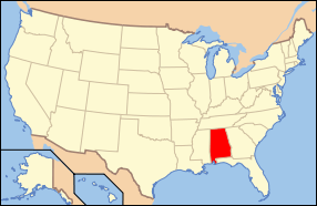
| Location | Roughly bounded by Norman Bridge & Cloverdale Rd., Fairview & Felder Aves. and Boultier St., Montgomery, Alabama |
|---|---|
| Coordinates | 32°21′18″N 86°17′42″W / 32.35500°N 86.29500°WCoordinates: 32°21′18″N 86°17′42″W / 32.35500°N 86.29500°W |
| Area | 156 acres (63 ha) |
| Architectural style | Mid 19th Century Revival, Late 19th And Early 20th Century American Movements, Late 19th And 20th Century Revivals |
| NRHP Reference # | 85002161[1] |
| Added to NRHP | September 12, 1985 |
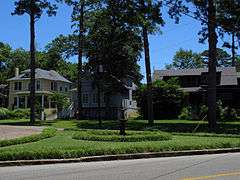
The Cloverdale Historic District is a 156-acre (63 ha) historic district in Montgomery, Alabama. It is roughly bounded by Norman Bridge and Cloverdale roads, Fairview and Felder avenues, and Boultier Street. It contains 463 contributing buildings and 4 structures that date from the mid-19th to the early 20th centuries.[2] The district was placed on the National Register of Historic Places on September 12, 1985.[1]
References
| Wikimedia Commons has media related to Cloverdale Historic District. |
- 1 2 National Park Service (2009-03-13). "National Register Information System". National Register of Historic Places. National Park Service.
- ↑ Dolan, Tom (July 1985). "Cloverdale Historic District" (PDF). National Register of Historic Places Inventory-Nomination Form. National Park Service. Archived (PDF) from the original on March 15, 2014. Retrieved March 15, 2014. See also: "Accompanying photos" (PDF). Archived (PDF) from the original on March 15, 2014. Retrieved March 15, 2014.

This article is issued from Wikipedia - version of the 11/27/2016. The text is available under the Creative Commons Attribution/Share Alike but additional terms may apply for the media files.