Coatepec, Veracruz
Coordinates: 19°27′00″N 96°58′00″W / 19.45°N 96.966667°W
The municipality of Coatepec(Spanish ![]() [koatepe'c] ) is found in the central region of the Mexican state of Veracruz. Its north latitude is 19° 27', west longitude is 96° 58', altitude of 1200.00 m, and surface of 255.81 km². It represents the 0.338% of the current state. The municipal seat and largest community of the municipality is also called Coatepec. The Mexican census of 2005 reported a population of 49,608 in the city, while the municipality had 79,787 inhabitants. The municipality also includes many smaller communities within its boundaries. The largest of these are Tuzamapan, Pacho Viejo, and Mahuixtlán.
[koatepe'c] ) is found in the central region of the Mexican state of Veracruz. Its north latitude is 19° 27', west longitude is 96° 58', altitude of 1200.00 m, and surface of 255.81 km². It represents the 0.338% of the current state. The municipal seat and largest community of the municipality is also called Coatepec. The Mexican census of 2005 reported a population of 49,608 in the city, while the municipality had 79,787 inhabitants. The municipality also includes many smaller communities within its boundaries. The largest of these are Tuzamapan, Pacho Viejo, and Mahuixtlán.
Details
Coatepec borders the municipalities of Xalapa and Tlalnelhuayocan (north); Teocelo and Jalcomulco (south); Emiliano Zapata (east); and Xico and Teocelo (west).
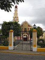
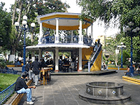
Often called the capital of Coffee in Mexico, the name Coatepec comes from the Nahuatl coatl, serpent and tepetl, hill (The Hill where the Snakes are).
This municipality has four small rivers: the Pixquiac, "Pintores", "Sordo" and Hueyapan; all going to "Pescados" ("La Antigua") river.
Coatepec was named a "Pueblo Mágico" in 2006.
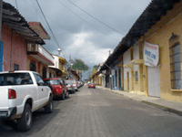
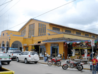
Coatepec is known for its coffee, which has a type which both tastes and looks good. The best option to buy coffee in Coatepec, Veracruz is in "La Vereda" or in "Bola de Oro", you almost need to know "Bola de Oro" because is the most popular in the country. And talking about other theme, Coatepec is popular about traditions, here the most important tradition is "Sán Jerónimo" that the people celebrates the September 30. The food that is popular in Coatepec by the population and tourists is (Tamales, Chilaquiles, Enmoladas, Gorditas, Lupitas, enfrijoladas, etc).
Climate
Coatepec's yearly median temperature is 19.5 °C (67 °F). Seasonal variations in temperature are moderate as elsewhere in central Mexico, whilst precipitation has more pronounced changes. The warmest month is May, when temperatures top 30 °C (86 °F) on average, although at night because of the high elevation the mercury drops to 15 °C (59 °F). The coolest month is January with temperatures varying from 9 °C (48 °F) to 22 °C (72 °F). Precipitation is at its lowest during the spring months (however still some rainfall falls from late cold fronts or early thunderstorm activity). Rainfall peaks at two times during the year, in June, at the beginning of the rainy season, and in September, towards the end of it. During these months precipitation exceeds on average 300 mm (11.8 in) and have been as high as over 25 in (640.7 mm in September 1974). The city's mild to warm temperatures have their extremes in 33 °C (92 °F) in May 1984 and -1 °C (28 °F) during February, 1976. There are 161 days with rain each year, while fog is common during the winter months.
| Coatepec | ||||||||||||||||||||||||||||||||||||||||||||||||||||||||||||
|---|---|---|---|---|---|---|---|---|---|---|---|---|---|---|---|---|---|---|---|---|---|---|---|---|---|---|---|---|---|---|---|---|---|---|---|---|---|---|---|---|---|---|---|---|---|---|---|---|---|---|---|---|---|---|---|---|---|---|---|---|
| Climate chart (explanation) | ||||||||||||||||||||||||||||||||||||||||||||||||||||||||||||
| ||||||||||||||||||||||||||||||||||||||||||||||||||||||||||||
| ||||||||||||||||||||||||||||||||||||||||||||||||||||||||||||
References
- Link to tables of population data from Census of 2005 INEGI: Instituto Nacional de Estadística, Geografía e Informática
- Veracruz Enciclopedia de los Municipios de México
External links
- Ayuntamiento de Coatepec Official website for the 2005-2007 administration
- Site with Tourist information about Coatepec
- Site of government Current administration
- (Spanish) Municipal Official Information
- Cultural festival
- Geographical information in Tagzania
- El Retoño Ecolodge