Coatetelco
 Main Pyramid | |
| Name: | Coatetelco |
| Location | Miacatlán, Morelos |
| Coordinates | 18°43′36″N 99°19′44″W / 18.72667°N 99.32889°WCoordinates: 18°43′36″N 99°19′44″W / 18.72667°N 99.32889°W |
| Culture | Tlahuica & Nahuatl |
| Period | Late Preclassical Mesoamerican Period |
| Language | Tlahuica |
| INAH Official Page | Coatetelco Site Coatetelco Web Page |
Coatetelco or Cuatetelco, is a prehispanic archaeological site located next to the Coatetelco Lagoon, two kilometers from Alpuyeca, in the Miacatlán municipality, Morelos State, México, near Xochicalco, had an important development between 500 y 150 BCE.
Name
Coatetelco means "Place of snakes mounds" or "Place where there are erected mounds in honor of snakes", however there are several versions on name variation:
- Cuatetelco, Náhuatl: Cuahuitl = Tree, branch, wood. Tetelli = Mound, bunch. Cotl, co = Place of, means, “Mound place between trees “ ó “Tree place on a mound”.
- Cuahtetelco, Coatl = Snake. Tetl = Stone. Co, Cotl = Place of. Means: “Place of the Stone Snake”.
- Quahtetelco, the Tlahuica Glyph, has a tree (Nahuatl= quahuitl en náhuatl) over a pyramid (tetelli). The word “co” is “place of …”. (Cuahtetelco Museum, official Guide, Sep. 13 1978. Pág. 5 p. 1-2).
- Cuauhtetelco.[1]
Background
At the end of the pleistocene, in this zone of the now state of Morelos as well as in the Mexico Plateau lived people whose diet was based in hunting-gathering of plants and fishing, living in rocky shelters. That first stage of human occupation dates back to 25,000 years ago.[2]
During the Early Formative or Preclassical period, the human dwellings were small villages with less than 100 inhabitants; developed farming lands near the rivers. The ceramic produced was similar to that of the Basin of Mexico and the first clay figurines were also made.[2]
In the Mid-Preclassical period (900-500 BCE.), villages were concentrated on the banks of the Chalma River, and the inhabitants practiced farming. Then the ceramic had strong local features, different from others, although there was some similarity with the Basin of Mexico.[2]
The Coatetelco apogee took place in the Late Preclassical period (500-150 BCE) At that time the communities had 250 to 500 inhabitants. It can be affirmed, by the excavations in the zone, that there has been human occupation since the epoch of the Teotihuacan influence (450-600 A.C.) even when the remaining constructions correspond to the Late Postclassical (1350–1521) mainly in the Mexica epoch. Buildings had four construction stages.[2]
When Xochicalco declined - around 1000 CE - Miacatlán becomes the leading center in the region. Subsequent history can rebuilt based on written documents and codices.[2]
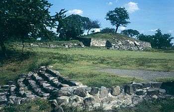
Site
Coatetelco was a medium-sized urban site. The central part of the city has been excavated and restored, including a ball, a small pyramid-temple, and several other structures, clustered around a public square. There is a small site Museum.[3]
Coatetelco was excavated in the 1970s by archaeologist Raúl Arana, who supervised reconstruction of the architecture. Several minor excavations have been done since that time to keep the site in good condition. Ceramics from Arana’s excavations are described in a monograph. (Smith 2002, s.f.) [3]
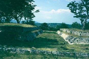
The architectural complex consists of pyramidal bases, platforms, and a ball game court made with an earth core and covered with carved stones. Some sections still have walls and stairs with stucco remains. The structures distribution around a square was integrated to the terrain topography.[2]
Western platform
It is a three bodies structure, almost destroyed, and two stairways with side rafters. At the top of the structure are floor stuicco remains and two stone "boxes". At a side of the platform is a smaller platform with two steps. Stone cylinder artifacts were discovered here, their purpose or use is not known.[3]
Ballgame court
Located behind the western platform.
It is one of the smallest in its class. Its presence is decisive to consider the place as a ceremonial center. The game had a religious purpose, as well as recreational and political. Its header is closed: It is oriented north-south. The structure has traces of the stucco. Tzompantli remains were found and are associated with the court.[2]
The ballgame court exemplifies a small ballgame court. Excavations under the main stairway of the platform, found elite burials with hundreds of funeral offerings, including ceramic vessels, obsidian, jade, and copper-bronze artifacts. Also found a group of Batan (Stone), basaltic utensils for grinding corn on a metate, carefully arranged at a side of the ballgame court and visible today.[3]
Extension platform
It is an extension of the Ball Game Court and the Circular Basement. It has a circular design and it is almost sure that it was dedicated to Ehécatl, the Wind God.[2]
Eastern platform
It has several semidetached buildings that possibly were altars. Its importance as a ceremonial site was confirmed with the findings of collective and individual burial places. Tombs and different kinds of offerings were found in the Altar and stairs.[2]
Incense altar
It is an altar, identified due to a stone sculpture representing a female character and some clay incense burners were found during the excavations. The form of these is easily identified in the Mendocino Codex; they resemble big ladles of long handles.[2]
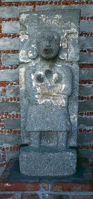
Xipe-Totec platform

It is the last of the semidetached basement. It was given this name because in it was found a Xipe-Totec stone sculpture. This is supported by the association to the circular altar and a stone called temalacatl was found in the rubble of a 16th-century chapel. This is a sacrificial stone that in the Mexica religion was related to Xipe-Totec deity. The figure was fragmented (it lacked head and feet). It is believed that the fracture was due to the Spanish practice to destroy the new cultures it found.[2]
On the topic of Spanish destruction, the following text was written in English, in 1886, by Swedish Archaeologist, Carl Bovallius. “Indeed, reading the scanty descriptions of the last days of these nations, one feels tempted to assert that in harmonic development of the mental faculties they were superior to that nation, which, by its crowds of rapacious and sanguinary adventurers, honored in history with the name of “los Conquistadores”, has fixed upon itself the heavy responsibility for the annihilation of this civilization. For indeed so swift and radical was this annihilation, through the fanatical vandalism of “Christian” priests and the bloody crimes of a greedy soldatesca, that history knows of no similar example. Thus the investigator of the comparatively modern culture of Central America is obliged to travel by more toilsome and doubtful roads than the student of the ancient forms of civilization of Egypt and India, although these were dead several thousands of years ago.[4]
Cuauhtlitzin temple
It is called the Main Temple because it is the highest structure. A wide flight of stairways with lateral rafters lead to the top; vestiges of a temple are there. The pyramidal bodies of the basement are built in slope and stuccoed. At the foot of stairway is a badly damaged Stele.[2]
During the exploration a feminine stone sculpture identified as Cuauhtlitzin was found. The feminine sculpture corresponds to a sculpted head that was placed inside a carved stone vault with the specific purpose of hiding it.[2]
Climate
| Climate data for Coatetelco | |||||||||||||
|---|---|---|---|---|---|---|---|---|---|---|---|---|---|
| Month | Jan | Feb | Mar | Apr | May | Jun | Jul | Aug | Sep | Oct | Nov | Dec | Year |
| Average high °C (°F) | 29.9 (85.8) |
32.6 (90.7) |
34.6 (94.3) |
36.6 (97.9) |
36.8 (98.2) |
33.3 (91.9) |
32.6 (90.7) |
32.5 (90.5) |
32 (90) |
32 (89.6) |
32 (89.6) |
30.8 (87.4) |
33 (91.4) |
| Average low °C (°F) | 8.4 (47.1) |
9.8 (49.6) |
12.4 (54.3) |
15.5 (59.9) |
17.3 (63.1) |
17.4 (63.3) |
16.6 (61.9) |
16.4 (61.5) |
16.6 (61.9) |
14.2 (57.6) |
11.3 (52.3) |
9.2 (48.6) |
13.8 (56.8) |
| Average precipitation mm (inches) | 3 (0.1) |
0 (0) |
3 (0.1) |
5 (0.2) |
38 (1.5) |
180 (7.1) |
234 (9.2) |
157 (6.2) |
168 (6.6) |
69 (2.7) |
5 (0.2) |
0 (0) |
861 (33.9) |
| Source: Weatherbase [5] | |||||||||||||
References
- ↑ INAH-SEP Guide from 1978, the map has the “Cuauhtetelco” name and not “Coatetelco”
- 1 2 3 4 5 6 7 8 9 10 11 12 13 Konieczna, Bárbara. "Pagina Web Coatetelco" [Coatetelco Web Page] (Hernández L., J. Antonio). INAH (in Spanish). México. Retrieved Sep 2010. Check date values in:
|access-date=(help) - 1 2 3 4 "Ruinas Tlahuica Cerca de Cuernavaca" [Tlahuica Ruins, near Cuernavaca]. Info Morelos. Retrieved August 2010. Check date values in:
|access-date=(help) - ↑ Bovallius, Carl (1886). "Nicaraguan Antiquities – Carl Bovallius". Swedish Society of Anthropology and Geography (KONGL. BOKTRYCKERIET. P.A. NORSTEDT & SÖNER, Stockholm.). Retrieved October 2010. Check date values in:
|access-date=(help) - ↑ "Weatherbase: Historical Weather for Coatetelco, Morelos". Weatherbase. 2011. Retrieved on November 24, 2011.
Bibliography
- Angulo Villaseñor, Jorge. 1978 Cuauhtetelco Museum: Official Guide. Instituto Nacional de Antropología e Historia, Mexico.
- Arana, Raúl. 1976 Coatetelco Investigation. Unpublished Report submitted to the Centro Regional Morelos, Instituto Nacional de Antropología e Historia.
- Smith, Michael E. n.d. Tlahuica Ceramics: The Aztec-Period Ceramics of Morelos, Mexico, Report.
- INAH 1992, Primera reimpresión, 1999 Consejo nacional para la Cultura y las Artes. Autora: Arqueóloga Bárbara Konieczna Z. Fotografía: Enrique Vela.
- Coatetelco, Pueblo de pescadores. Teódula Alemán Cleto Editorial, Qualy gráficos.
- El museo de Cuahtetelco, guía oficial, INAH-SEP México, 1978
- Religiosidad indígena, historia y etnografía, Coatetelco, Morelos Druzo Maldonado Jiménez INAH México, 2005
- Notas etnográficas: Coatetelco Irving Reynoso Jaime, Jesús Castro PACMyC México, 2002
External links
Further reading
- Bovallius, Carl (1886). Nicaraguan Antiquities. Swedish Society of Anthropology and Geography: KONGL. BOKTRYCKERIET. P.A. NORSTEDT & SÖNER, Stockholm.