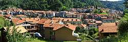
Coggiola
| Coggiola | |
|---|---|
| Comune | |
| Comune di Coggiola | |
 | |
 Coggiola Location of Coggiola in Italy | |
| Coordinates: 45°41′N 8°11′E / 45.683°N 8.183°ECoordinates: 45°41′N 8°11′E / 45.683°N 8.183°E | |
| Country | Italy |
| Region | Piedmont |
| Province / Metropolitan city | Province of Biella (BI) |
| Frazioni | Villa Sopra, Villa Sotto, Formantero, Ponte S.Giovanni, Vico, Zuccaro, Castello, Camplin, Viera, Rivò, Biolla, Viera Superiore, Casa Chieti, Piletta, Fervazzo |
| Area | |
| • Total | 23.7 km2 (9.2 sq mi) |
| Population (Dec. 2004) | |
| • Total | 2,285 |
| • Density | 96/km2 (250/sq mi) |
| Time zone | CET (UTC+1) |
| • Summer (DST) | CEST (UTC+2) |
| Postal code | 13863 |
| Dialing code | 015 |
Coggiola is a comune (municipality) in the Province of Biella in the Italian region Piedmont, located about 80 kilometres (50 mi) northeast of Turin and about 15 kilometres (9 mi) northeast of Biella. As of 31 December 2004, it had a population of 2,285 and an area of 23.7 square kilometres (9.2 sq mi).[1]
The municipality of Coggiola contains the frazioni (subdivisions, mainly villages and hamlets) Villa Sopra, Villa Sotto, Formantero, Ponte S.Giovanni, Vico, Zuccaro, Castello, Camplin, Viera, Rivò, Biolla, Viera Superiore, Casa Chieti, Piletta, and Fervazzo.
Coggiola borders the following municipalities: Ailoche, Caprile, Portula, Pray.
In the municipal territory there are two sanctuaries: Cavallero and Moglietti.
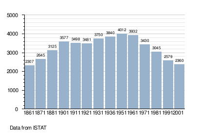
Demographic evolution
Twin towns — Sister cities
Coggiola is twinned with:
-
 La Fare-les-Oliviers, France