Colorado State Highway 116
| ||||
|---|---|---|---|---|
|
Map of Baca County in southeastern Colorado with SH 116 highlighted in red | ||||
| Route information | ||||
| Maintained by CDOT | ||||
| Length: | 32.20 mi[1] (51.82 km) | |||
| Major junctions | ||||
| West end: |
| |||
|
| ||||
| East end: | W Road 12 at Kansas state line | |||
| Location | ||||
| Counties: | Baca | |||
| Highway system | ||||
|
Colorado State Highways
| ||||

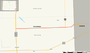
State Highway 116 (SH 116) is a fairly isolated state highway that runs from the Kansas state line (W Road 12) in the southeastern corner of the state.
Route description
The highway gives service though very rural country in Baca County through Two Buttes to the junction with US 287 and US 385 about 7 miles north of Springfield. The highway's maintenance is served by Two Buttes, the only town on its route. The town is the largest town for many miles in any direction.
Major intersections
The entire route is in Baca County. [2]
| Location[2] | mi[2] | km | Destinations | Notes | |
|---|---|---|---|---|---|
| | 0.000 | 0.000 | |||
| | 27.020 | 43.484 | |||
| 32.322 | 52.017 | W Road 12 – Johnson City | Continuation beyond Kansas state line | ||
| 1.000 mi = 1.609 km; 1.000 km = 0.621 mi | |||||
References
- ↑ "Segment list for SH 116". Retrieved 2007-05-12.
- 1 2 3 "Highway Data Explorer, Online Transportation Information System". Colorado Department of Transportation. Retrieved October 2, 2016.
External links
This article is issued from Wikipedia - version of the 10/2/2016. The text is available under the Creative Commons Attribution/Share Alike but additional terms may apply for the media files.