Colorado State Highway 140
| ||||
|---|---|---|---|---|
|
Map of La Plata County in southwestern Colorado with SH 140 highlighted in red | ||||
| Route information | ||||
| Maintained by CDOT | ||||
| Length: | 23.4 mi[1] (37.7 km) | |||
| Major junctions | ||||
| South end: |
| |||
| North end: |
| |||
| Location | ||||
| Counties: | La Plata | |||
| Highway system | ||||
|
Colorado State Highways
| ||||

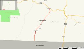
State Highway 140 is a 23.4 mi (37.7 km) long state highway in the southwestern corner of Colorado.
Route description
SH 140 begins in the south on the Southern Ute Indian Reservation at the New Mexico state line where the road becomes New Mexico State Road 170 coming from Farmington, NM. From the state line, the road proceeds northward passing near the town of Marvel and reaching its northern terminus at U.S. Highway 160 near the small town of Hesperus roughly eleven miles west of Durango.
Major intersections
The entire route is in La Plata County.
| Location | mi[1] | km | Destinations | Notes | |
|---|---|---|---|---|---|
| | 0.000 | 0.000 | Continuation beyond New Mexico state line; Southern terminus | ||
| Hesperus | 23.435 | 37.715 | Northern terminus | ||
| 1.000 mi = 1.609 km; 1.000 km = 0.621 mi | |||||
References
- 1 2 "Segment Descriptions for Highway 140". Colorado Department of Transportation. Retrieved 2008-04-07.
External links
This article is issued from Wikipedia - version of the 2/6/2016. The text is available under the Creative Commons Attribution/Share Alike but additional terms may apply for the media files.