Colorado State Highway 15
| ||||
|---|---|---|---|---|
|
Map of southern Colorado with SH 15 highlighted in red | ||||
| Route information | ||||
| Maintained by CDOT | ||||
| Length: | 22.834 mi[1] (36.748 km) | |||
| Major junctions | ||||
| West end: |
| |||
| East end: |
| |||
| Location | ||||
| Counties: | Rio Grande, Conejos | |||
| Highway system | ||||
|
Colorado State Highways
| ||||

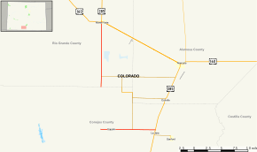
State Highway 15 in the U.S. state of Colorado is a north–south, east–west state highway in the San Luis Valley region of Southern Colorado. It connects the two towns of Monte Vista and Alamosa. There is a gap in the route.
Route description
The route begins at a concurrency between US 285 and US 160. After about 12 miles, at the Rio Grande-Conejos county line, there exists an eight-mile gap[1] filled in by Conejos County Route 6.[2] After the gap, SH 15 reappears, crosses over the La Jara Creek, and ends at US 285 south of Alamosa.
History
The route was established in the 1920s as a much longer route, but it was gradually cut down to its current length. The route was paved in 1957.[2]
Major intersections
| County | Location | mi[1] | km | Destinations | Notes | ||
|---|---|---|---|---|---|---|---|
| Rio Grande | Monte Vista | 0.000 | 0.000 | Western terminus | |||
| | |||||||
| Gap in route | |||||||
| Conejos | | 30.915 | 49.753 | Eastern terminus | |||
| 1.000 mi = 1.609 km; 1.000 km = 0.621 mi | |||||||
References
- 1 2 3 "Segment list for SH 15". Retrieved 2007-05-12.
- 1 2 "Colorado Routes 1-19". Retrieved April 1, 2010.
External links
This article is issued from Wikipedia - version of the 2/14/2016. The text is available under the Creative Commons Attribution/Share Alike but additional terms may apply for the media files.