Colorado State Highway 170
| ||||
|---|---|---|---|---|
|
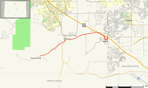
Map of Boulder County in north central Colorado with SH 170 highlighted in red | ||||
| Route information | ||||
| Maintained by CDOT | ||||
| Length: | 6.969 mi[1] (11.216 km) | |||
| Location | ||||
| Counties: | Boulder | |||
| Highway system | ||||
|
Colorado State Highways
| ||||

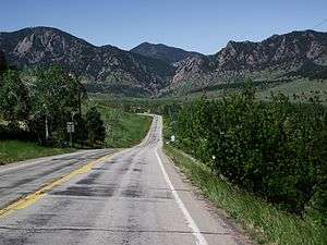
State Highway 170 approaching Eldorado Springs
State Highway 170 (SH 170) is a state highway in Colorado that connects Eldorado Springs and Superior.
Route description
The road begins at the edge of Eldorado Canyon State Park at El Dorado Springs. SH 170 then heads eastward, meeting County Road 67 before passing through a rural grassy area. The route then meets State Highway 93, where it becomes Marshall Drive, just north of Marshall Lake. The road then finds its eastern terminus at U.S. Highway 36, the Denver-Boulder Turnpike, passing through the city of Superior.[2]
Major intersections
The entire route is in Boulder County.
| Location | mi | km | Destinations | Notes | |
|---|---|---|---|---|---|
| Eldorado Springs | 0.000 | 0.000 | Eldorado Canyon State Park | ||
| | 2.735 | 4.402 | |||
| Superior | 6.969 | 11.216 | |||
| 1.000 mi = 1.609 km; 1.000 km = 0.621 mi | |||||
References
External links
This article is issued from Wikipedia - version of the 2/6/2016. The text is available under the Creative Commons Attribution/Share Alike but additional terms may apply for the media files.