Conesus Lake
| Conesus Lake | |
|---|---|
|
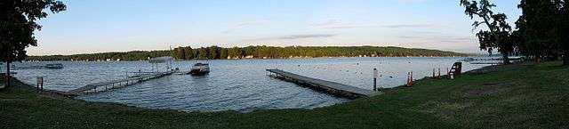
The east shore, seen from Long Point Park | |
| Location |
Livingston County, New York, United States |
| Group | Finger Lakes |
| Coordinates | 42°46′47″N 77°43′00″W / 42.77972°N 77.71667°WCoordinates: 42°46′47″N 77°43′00″W / 42.77972°N 77.71667°W |
| Lake type | Glacial |
| Basin countries | United States |
| Max. width | 8 mi (13 km) |
| Max. depth | 66 ft (20 m) |
| Surface elevation | 817 ft (249 m)[1] |
Conesus Lake /kəˈniːʃəs/ is the westernmost of New York's eleven Finger Lakes. It is located off Interstate 390 about 15 miles (24 km) south of Interstate 90.
Description
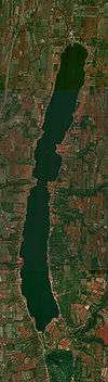
Conesus Lake flows south to north, from its inlet in the Town of Conesus to its outlet, Conesus Creek, in Lakeville, a hamlet in the Town of Livonia in Livingston County. Conesus Creek in turn flows into the Genesee River near Avon.
Conesus Lake is eight miles (13 km) long, with a maximum depth of 66 feet (20 m).
In August 2006, the New York State Department of Environmental Conservation confirmed that the lake was the first outside the contiguous Great Lakes waterways to be stricken with a new strain of viral hemorrhagic septicemia (VHS), an infectious fish disease responsible for mass die-offs of many species, but not linked to any human health concerns.[2][3] The disease is spread between waterways through live or frozen bait fish, roe, contaminated fishing equipment or live water wells in boats.
The U.S.S. Lady of the Lake is reportedly sunken in Conesus Lake.
Recreation
When frozen over in the winter, Conesus Lake is used for snowmobiling and ice fishing.
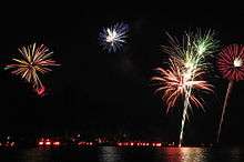
On July 3 of each year, the residents of the lake participate in a tradition called the "Ring of Fire", sponsored by the Conesus Lake Association. Participants light road flares around the lake and shoot off fireworks. The festivities typically start at dusk, with approximately 10,000 flares lit at 10:00 PM.
See also
 Finger Lakes portal
 Media related to Conesus Lake at Wikimedia Commons
References
- ↑ "Conesus Lake". Geographic Names Information System. United States Geological Survey. Retrieved June 8, 2015.
- ↑ Crawford, Franklin (May 17, 2007). "Cornell researchers confirm that deadly fish virus has spread to 19 species, threatening sport-fishing industry". Cornell Chronicle. Cornell University. Retrieved July 14, 2007.
- ↑ "Viral Hemorrhagic Septicemia (VHS) in New York". New York State Department of Environmental Conservation. Retrieved August 8, 2009.