Connaught Square (Thunder Bay)
| Connaught Square | |
|---|---|
|
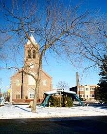
Connaught Square and Centennial Shelter, with St. Andrew's Roman Catholic Church in the background. | |
| Location | Thunder Bay, Ontario, Canada |
| Coordinates | 48°26′12″N 89°13′27″W / 48.43667°N 89.22417°WCoordinates: 48°26′12″N 89°13′27″W / 48.43667°N 89.22417°W |
| Area | 1,000 m2 (11,000 sq ft) |
| Operated by | City of Thunder Bay, Parks Division |
Connaught Square is a public park located in the north end of Thunder Bay, Ontario, Canada. It is located directly east of Waverley Park across Algoma Street, formed by the conflux of Waverly Street and Red River Road. The square was originally named Gore Park, then renamed in 1936 for Prince Arthur, Duke of Connaught,[1] after whom the former city of Port Arthur (originally Prince Arthur's Landing) was named. It covers a quarter of an acre, or 1,000 square metres. Contrary to its name is actually triangular.[1]
A cairn, built in 1925,[1] at the eastern corner of the park describes its history, and behind it lies the Geodetic Survey of Canada's bench mark for Port Arthur. The bench mark states that it is located 677.7 feet (206.6 m) above mean sea level.
Located in the centre of Connaught Square is the Centennial Shelter, a project built to commemorate the 100th anniversary of Canada in 1967. During the Christmas season, the Knights of Columbus erect a nativity scene beneath the canopy, and a pine tree located just to the east is decorated with coloured lights.
See also
References
- 1 2 3 Tronrud, Thorold J. & Nicholson, David (2005). Thunder Bay Quiz Book: 101 Fascinating Questions about our History. Thunder Bay Historical Museum Society, pps. 22 (question) and 52 (answer) ISBN 0-920119-50-6.
External links
- Thunder Bay Unseen: Waverly Park Heritage Conservation District Street Tour
- Thunder Bay Online Map Viewer - Waverley and Connaught Parks (Requires Internet Explorer)