Cook Strait
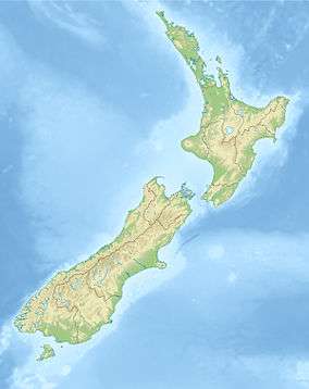
Cook Strait lies between the North and South Islands of New Zealand. It connects the Tasman Sea on the northwest with the South Pacific Ocean on the southeast, and runs next to the capital city, Wellington. It is 22 kilometres (14 mi) wide at its narrowest point,[1] and is considered one of the most dangerous and unpredictable waters in the world.[2]
The strait is named after James Cook, the first European commander to sail through it, in 1770. In Māori it has the name Raukawa or Raukawa Moana. Raukawa may mean "bitter leaves".[3]
History

In Māori legend, Cook Strait was discovered by Kupe the navigator. Kupe followed in his canoe a monstrous octopus called Te Wheke-a-Muturangi across Cook Strait and destroyed it in Tory Channel or at Pātea.
When Dutch explorer Abel Tasman first saw New Zealand in 1642, he thought Cook Strait was a bight closed to the east. He named it Zeehaen's Bight, after the Zeehaen, one of the two ships in his expedition. In 1769 James Cook established that it was a strait, which formed a navigable waterway.
Cook Strait attracted European settlers in the early 19th century. Because of its use as a whale migration route, whalers established bases in the Marlborough Sounds and in the Kapiti area.[4][5] From the late 1820s until the mid-1960s Arapaoa Island was a base for whaling in the Sounds. Perano Head on the east coast of the island was the principal whaling station for the area. The houses built by the Perano family are now operated as tourist accommodation.[6]
During the 1820s Te Rauparaha led a Māori migration to, and the conquest and settlement of, the Cook Strait region.
From 1840 more permanent settlements sprang up, first at Wellington, then at Nelson and at Whanganui (Petre). At this period the settlers saw Cook Strait in a broader sense than today's ferry-oriented New Zealanders: for them the strait stretched from Taranaki to Cape Campbell, so these early towns all clustered around "Cook Strait" (or "Cook's Strait", in the pre-Geographic Board usage of the times) as the central feature and central waterway of the new colony.
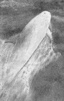
Between 1888 and 1912 a Risso's dolphin named Pelorus Jack became famous for meeting and escorting ships around the Cook Strait. Pelorus Jack was usually spotted in Admiralty Bay between Cape Francis and Collinet Point, near French Pass, a channel used by ships travelling between Wellington and Nelson. Pelorus Jack is also remembered after he was the subject of a failed assassination attempt. He was later protected by a 1904 New Zealand law.
At times when New Zealand feared invasion, various coastal fortifications were constructed to defend Cook Strait. During the Second World War, two 9.2 inch (23 cm) gun installations were constructed on Wrights Hill behind Wellington. These gun could range 18 miles (29 km) across Cook Strait. In addition thirteen 6-inch (15 cm) gun installations were constructed around Wellington, along the Makara coast, and at entrances to the Marlborough Sounds. The remains of most of these fortifications can still be seen.
The Pencarrow Head Lighthouse was the first permanent lighthouse built in New Zealand. Its first keeper, Mary Jane Bennett, was the only female lighthouse keeper in New Zealand's history. The light was decommissioned in 1935 when it was replaced by the Baring Head Lighthouse.
A number of ships have been wrecked with significant loss of life, such as the Maria in 1851,[7] the City of Dunedin in 1865,[8] the St Vincent in 1869,[7] the Lastingham in 1884,[9] SS Penguin in 1909 and TEV Wahine in 1968.
Geography
The strait runs in a general NW-SE direction, with the South Island on the west side and North Island on the east. At its narrowest point, 22 kilometres (14 mi) separate Cape Terawhiti in the North Island from Perano Head on Arapaoa Island in the Marlborough Sounds.[1] Perano Head is actually further north than Cape Terawhiti. In good weather one can see clearly across the strait.
The west (South Island) coast runs 30 kilometres (19 mi) along Cloudy Bay and past the islands and entrances to the Marlborough Sounds. The east (North Island) coast runs 40 kilometres (25 mi) along Palliser Bay, crosses the entrance to Wellington harbour, past some Wellington suburbs and continues another 15 kilometres (9.3 mi) to Makara beach.
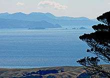
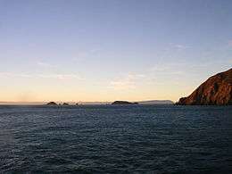
The Brothers is a group of tiny islands in Cook Strait off the east coast of Arapaoa Island. North Brother island in this small chain is a sanctuary for the rare Brothers Island tuatara, while the largest of the islands is the site of the Brothers Island Lighthouse.
 View from Cape Koamaru of the Brothers Islands with Wellington west coast on the horizon
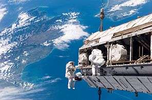 International Space Station assembly EVA made during the STS-116 mission, over Cook Strait (New Zealand)
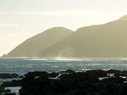 Wellington's south coast, seen from Island Bay
Geology
The shores of Cook Strait on both sides are mostly composed of steep cliffs. The beaches of Cloudy Bay, Clifford Bay, and Palliser Bay shoal gently down to 140 metres (460 ft), where there is a more or less extensive submarine plateau. The rest of the bottom topography is complex. To the east is the Cook Strait Canyon with steep walls descending eastwards into the bathyal depths of the Hikurangi Trench. To the north-west lies the Narrows Basin, where water is 300 and 400 metres (980 and 1,310 ft) deep. Fisherman's Rock in the north end of the Narrows Basin rises to within a few metres of low tide, and is marked by waves breaking in rough weather. A relatively shallow submarine valley lies across the northern end of the Marlborough Sounds. The bottom topography is particularly irregular around the coast of the South Island where the presence of islands, underwater rocks, and the entrances to the sounds, create violent eddies.[1] The strait has an average depth of 128 metres (420 ft).
The South and North Islands were joined during the last ice age.
Oceanography
|
| |
|
| |
|
| |
|
|
The waters of Cook Strait are dominated by strong tidal flows. The tidal flow through Cook Strait is unusual in that the tidal elevation at the ends of the strait are almost exactly out of phase with one another, so high water on one side meets low water on the other. Strong currents result, with almost zero tidal height change in the centre of the strait. Although the tidal surge should flow in one direction for six hours and then the reverse direction for six hours, a particular surge might last eight or ten hours with the reverse surge enfeebled. In especially boisterous weather conditions the reverse surge can be negated, and the flow can remain in the same direction through three surge periods and longer. This is indicated on marine charts for the region.[10] Furthermore, the submarine ridges running off from the coast complicate the ocean flow and turbulence.[11]
There are numerous computer models of the tidal flow through Cook Strait. While the tidal components are readily realizable,[12] the residual flow is more difficult to model.[13]
Tidal power
In April 2008, a resource consent was granted to Neptune Power for the installation of a $10 million experimental underwater tidal stream turbine capable of producing one megawatt. The turbine has been designed in Britain, and will be built in New Zealand. It will be 14 metres (46 ft) in diameter and constructed of carbon fibre. It will be placed in 80 metres (260 ft) of water, 4.5 kilometres (2.8 mi) due south of Sinclair Head, in waters known as the “Karori rip”. Power from the turbine will be brought ashore at the Island Bay substation. The turbine is a pilot, and will be sited in slower tides for testing. Neptune hopes to generate power from the unit by 2010. The company claims there is enough tidal movement in Cook Strait to generate 12 GW of power, more than one-and-a-half times New Zealand's current requirements.[14][15][16][17] In practice, only some of this energy could be harnessed.[18] As of October 2016 the Neptune Power website is a placeholder with no further announcements.
On the other side of the strait, Energy Pacifica has applied for resource consent to install up to 10 marine turbines, each able to produce up to 1.2 MW, near the Cook Strait entrance to Tory Channel. The company claims that Tory Channel is an optimal site with a tidal current speed of 3.6 metres per second (12 ft/s) and the best combination of bathymetry and accessibility to the electricity network.[17]
The power generated by tidal marine turbines varies as the cube of the tidal speed. Because the tidal speed doubles, eight times more tidal power is produced during spring tides than at neaps.[17]
Cables
Electric power and communication cables link the North and South Islands across Cook Strait, operated by Transpower.[19]
Three submarine power cables cross Cook Strait between Oteranga Bay in the North Island and Fighting Bay in the South Island as part of the HVDC Inter-Island, which provides an electricity link between Benmore in the South island and Haywards in the North Island. Each cable operates at 350 kV, and can carry up to 500 MW, with Pole 2 of the link using one cable and Pole 3 using two cables. The link's capacity is 1200 MW, but restricted to 1000 MW due to inadequate voltage support at Haywards. The cables are laid on the seabed within a legally defined zone called the cable protection zone (CPZ). The CPZ is about 7 kilometres (4 mi) wide for most of its length, narrowing where it nears the terminals on each shore. Fishing activities and anchoring boats are prohibited within the CPZ.[19]
Fibre optic cables carry telecommunications across Cook Strait, used by New Zealand’s main telecommunication companies for domestic and commercial traffic and by Transpower for control of the HVDC link.
Marine life
Cook Strait is an important habitat for many cetacean species. Several dolphins (bottlenose, common, dusky) frequent the area along with killer whales and the endemic Hector's dolphins. Long-finned pilot whales often strand en masse at Golden Bay. The famous Pelorus Jack was a Risso's dolphin being observed escorting the ships between 1888 and 1912, though this species is not a common visitor to the New Zealand's waters. Large migratory whales attracted many whalers to the area in the winter. Currently, an annual survey of counting humpback whales is taken by Department of Conservation and former whalers help DOC to spot animals by using several vantage points along the strait such as on Stephens Island. Other occasional visitors include southern right whales, blue whales, sei whales and sperm whales. Giant squid specimens have been washed ashore around Cook Strait or found in the stomachs of sperm whales off Kaikoura.
A colony of male fur seals has long been established near Red Rocks on the south Wellington coast.[20] Cook Strait offers good game fishing. Albacore tuna can be caught from January to May. Broadbill swordfish, bluenose, mako sharks and the occasional marlin and white shark can also be caught.[21]
Transport
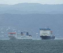
Regular ferry services run between Picton in the Marlborough Sounds and Wellington, operated by KiwiRail (the Interislander) and Strait Shipping (Bluebridge). Both companies run services several times a day. Roughly half the crossing is in the strait, and the remainder within the Sounds. The journey covers 70 kilometres (43 mi) and takes about three hours. The strait often experiences rough water and heavy swells from strong winds, especially from the south. New Zealand's position directly athwart the roaring forties means that the strait funnels westerly winds and deflects them into northerlies. As a result, ferry sailings are often disrupted and Cook Strait is regarded as one of the most dangerous and unpredictable waters in the world. On 10 April 1968, the TEV Wahine, a Wellington–Lyttelton ferry of the Union Company, foundered at the entrance to Wellington Harbour and capsized. Of the 610 passengers and 123 crew on board, 53 died.[22]
Air lines which operate or have operated flights across Cook Strait include Straits Air Freight Express, Air2there, CityJet and Sounds Air.
Swimming
According to oral tradition, the first woman to swim Cook Strait was Hine Poupou. She swam from Kapiti Island to D'Urville Island with the help of a dolphin.[23] Other Māori accounts tell of at least one swimmer who conquered the strait in 1831.
In modern times, the strait was first swum by Barrie Devenport in 1962. Lynne Cox was the first woman to swim it, in 1975. The most prolific swimmer of the strait is Philip Rush, who has crossed eight times, including two double crossings. Aditya Raut was the youngest swimmer at 11 years. Stephanie Bennington was the youngest female swimmer at 13 years. Pam Dickson was the oldest swimmer at 55 years.[24] John Coutts was the first person to swim the strait in both directions.[25] By 2010, 74 single crossings had been made by 65 individuals, and three double crossings had been made by two individuals (Philip Rush and Meda McKenzie). In March 2016, Marilyn Korzekwa became the first Canadian and oldest woman, at 58 years old, to swim the strait. Marilyn swam to raise funds and awareness for Canadian charity, Sashbear.org. Crossing times are largely determined by the strong and sometimes unpredictable currents that operate in the strait.[24]
Timeline
- Prehistory: The mythical navigator Kupe follows, in his canoe, the octopus Te Wheke-a-Muturangi across Cook Strait.
- 1642: Abel Tasman mistook Cook Strait for a bight.
- 1769: James Cook established it is a strait
- 1822: Ngati Toa migrated to Cook Strait region, led by Te Rauparaha.
- 1831: Whaling station established in Tory Channel.
- 1851: Maria wrecked in on rocks at Cape Terawhiti, 26 people killed.
- 1855: Severe earthquake on both sides of Cook Strait.
- 1865: PS City of Dunedin sank in Cook Strait, 39 people killed.
- 1866: Cook Strait submarine telegraph cable laid.
- 1869: St Vincent wrecked in Palliser Bay, 20 people killed.
- 1879: Kangaroo laid the first telegraph cable across Cook Strait.
- 1884: Lastingham wrecked at Cape Jackson, 18 people killed.
- 1904: Pelorus Jack was protected by New Zealand law
- 1909: SS Penguin wrecked in Cook Strait, 75 people killed.
- 1920: First aeroplane flight across Cook Strait.
- 1935: Air services began across Cook Strait.
- 1962: Cook Strait rail ferry service began.
- 1962: Barrie Devenport swims the strait.
- 1964: Cook Strait power cables laid.
- 1968: TEV Wahine wrecked at entrance to Wellington harbour, 53 people killed.
- 1975: Lynne Cox became the first woman to swim the strait.
- 1979: Paul Caffyn crossed the strait in a sea kayak.
- 1984: Philip Rush swam the strait both ways.
- 1984: Meda McKenzie became the first woman to swim the strait both ways.
- 1991: Five new power and communication cables laid
- 1994: First fast-ferry service began operation across Cook Strait.
- 2002: Two further communications cables laid.
- 2005: The retired frigate HMNZS Wellington was sunk off Wellington as an artificial reef.
- 2008: A resource consent was granted to Neptune Power to install a $10 million experimental underwater tidal stream turbine capable of producing one megawatt.
- 2008: Energy Pacifica applies for resource consent to install up to 10 marine turbines, each able to produce up to 1.2 MW, near the Cook Strait entrance to Tory Channel.
- 2013: Two large earthquakes measuring 6.5 and 6.6 on the Richter Scale struck Cook Strait, causing significant damage in the town of Seddon, with minor to moderate damage in Wellington.
See also
Notes
- 1 2 3 McLintock, A H, Ed. (1966) Cook Strait from An Encyclopaedia of New Zealand, updated 18-Sep-2007. Note: This is the distance between the North Island and Arapaoa Island; some sources give a slightly larger reading of around 24.5 kilometres (15.2 mi), that between the North Island and the South Island.
- ↑ McLauchlan, Gordon (Ed.) (1987) New Zealand encyclopedia, Bateman, P. 121. ISBN 978-0-908610-21-1.
- ↑ Reed, A.W. (2002) The Reed dictionary of New Zealand place names. Auckland: Reed Books. ISBN 0-790-00761-4. p 99.
- ↑ McNab, Robert (1913) A History of Southern New Zealand from 1830 to 1840 Whitcombe and Tombs Limited. ASIN B000881KT4.
- ↑ Martin, Stephen (2001) The Whales' Journey: Chapter 4: The northerly migration Allen & Unwin. ISBN 978-1-86508-232-5
- ↑ Perano Homestead
- 1 2 Disasters and Mishaps – Shipwrecks, from An Encyclopaedia of New Zealand, edited by A. H. McLintock, originally published in 1966, updated 2007-09-18.
- ↑ Steamer 'City of Dunedin'- Mysterious Sinking
- ↑ Dive Lastingham Wreck
- ↑ Chart of Cook Strait
- ↑ Stevens, CL, M.J. Smith, B. Grant, C.L. Stewart,T. Divett, 2012, Tidal Stream Energy Extraction in a Large Deep Strait: the Karori Rip, Cook Strait, Continental Shelf Research, 33: 100-109. , DOI: 10.1016/j.csr.2011.11.012.
- ↑ Lunar tides in Cook Strait, New Zealand
- ↑ Bowman, M.J., A.C. Kibblewhite, R. Murtagh, S.M. Chiswell and B.G. Sanderson (1983) Circulation and mixing in greater Cook Strait, New Zealand. Oceanologica Acta 6(4): 383-391
- ↑ Doesburg, Anthony (15 April 2008). "Green light for Cook Strait energy generator trial". The New Zealand Herald. Retrieved 26 September 2011.
- ↑ Renewable energy development: Tidal Energy: Cook Strait Archived February 14, 2009, at the Wayback Machine.
- ↑ Harnessing the power of the sea Energy NZ, Vol 1, No 1, Winter 2007 Archived October 14, 2008, at the Wayback Machine.
- 1 2 3 Benign tides Energy NZ No.6, Spring 2008. Contrafed Publishing. Accessed 1 March 2009.
- ↑ Radio New Zealand
- 1 2 "Cook Strait submarine cable protection zone" (PDF). Transpower. 2006.
- ↑ Cook Strait seal colonies
- ↑ The Marlborough Sounds Marlborough online. Retrieved 3 October 2008.
- ↑ Initially the official toll was 51, but two names were added 22 and 40 years later respectively. Williamson, Kerry (9 April 2008). "Recognition 53rd Wahine victim". The Dominion Post. Retrieved 2008-04-10.
- ↑ Polynesian History
- 1 2 "Cook Strait Swim". Retrieved 31 October 2014.
- ↑ "Swimming: Coutts thrived outside comfort zone". Hawke's Bay Today. 13 April 2012. Retrieved 12 December 2015.
References
- Grady, Don (September 1982). Perano Whalers of Cook Strait, 1911-1964. Intl Specialized Book Service. p. 238. ISBN 978-0-589-01392-9.
- Harris, Thomas Frank Wyndham (1990). Greater Cook Strait. DSIR Marine and Freshwater. p. 212. ISBN 0-477-02580-3.
External links
| Wikimedia Commons has media related to Cook Strait. |
- Cook Strait: Ship Wrecks, Swells and Gales
- New Zealand's Cook Strait Rail Ferries – NZ National Maritime Museum
- Cook Strait rail ferries – New Zealand History, by Ministry for Culture and Heritage
- Cook Strait Swim
- NZ: Chance to turn the tide of power supply EnergyBulletin.net
- Lewis, Keith Submarine cables Te Ara - the Encyclopedia of New Zealand, updated 21-Sep-2007.
- History of Cable Bay Station
- A Powerful link: The Cook Strait Cable
- NZ Documentary Film (2007) Fish & Ships The Island Bay fishing fleet.
Coordinates: 41°13′46″S 174°28′59″E / 41.22944°S 174.48306°E