Coquihalla River
| Coquihalla River | |
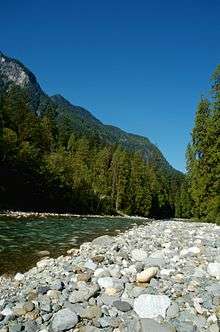 The Coquihalla River, just outside Hope, British Columbia | |
| Country | Canada |
|---|---|
| Province | British Columbia |
| Tributaries | |
| - left | Nicolum River |
| Mouth | Fraser River |
| - location | Hope, Cascade Mountains |
| - elevation | 38 m (125 ft) [1] |
| - coordinates | 49°23′36″N 121°26′21″W / 49.39333°N 121.43917°WCoordinates: 49°23′36″N 121°26′21″W / 49.39333°N 121.43917°W [2] |
| Discharge | for near Hope |
| - average | 29.8 m3/s (1,052 cu ft/s) [3] |
| - max | 650 m3/s (22,955 cu ft/s) |
| - min | 3.00 m3/s (106 cu ft/s) |
The Coquihalla River (originally local /ˌkɒkɪˈhælə/ or more recently and popularly /ˌkoʊkɪˈhælə/) is a tributary of the Fraser River in the Cascade Mountains of the Canadian province of British Columbia. It originates in the Coquihalla Lakes and empties into the Fraser River at Hope.
The Coquihalla River divides two portions of the Cascades, the Skagit Range and the Hozameen Range.[4][5] The river flows through a deep, narrow valley, dropping 3,400 feet (1,000 m) in 33 miles (53 km), a tumultuous course that creates an incessant roar.[4]
Kw'ikw'iyá:la in the Halkomelem language of the Stó:lō, is a place name meaning "stingy container" or "stingy place". It refers specifically to a deep pool named Skw'éxweq or Skw'exwáq, near the mouth of what is now known as the Coquihalla River. The Stó:lō would go to this pool to spear suckerfish, which were plentiful there. According to Stó:lō oral history, the s'ó:lmexw (black-haired, 2-foot tall, dark-skinned underwater people) would grab the spears, preventing fish from being caught. Thus they were stingy with the fish. There were two other pools in the rivers where this was said to happen.[6]
The Coquihalla Highway, which runs from Hope to Kamloops, derives its name from running alongside this river between Hope and the site of a former toll booth about 50 kilometres (31 mi) away. Portions of the motion picture First Blood were filmed there.
See also
| Wikimedia Commons has media related to Coquihalla River. |
References
- ↑ Elevation derived from ASTER Global Digital Elevation Model, using GeoLocator, and BCGNIS coordinates.
- ↑ "Coquihalla River". BC Geographical Names.
- ↑ "Archived Hydrometric Data Search". Water Survey of Canada. Retrieved 16 August 2013. Search for Station 08MF068 Coquihalla River above Alexander Creek
- 1 2 Beckey, Fred (2009). Cascade Alpine Guide: Climbing and High Routes: Rainy Pass to Fraser River (3rd ed.). The Mountaineers. p. 185. ISBN 978-0-89886-423-6.
- ↑ "Skagit Range, Canadian 1:50K topographic maps" (map). TopoQuest.com. Retrieved 17 August 2013.
- ↑ Galloway, Brent Douglas (2009). Dictionary of Upriver Halkomelem. University of California Press. p. 192. ISBN 978-0-520-94518-0. Retrieved 16 August 2013.