Corcogemore
| Corcogemore | |
|---|---|
| Corcóg | |
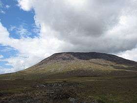 Corcogemore from the R336 | |
| Highest point | |
| Elevation | 609 m (1,998 ft) [1] |
| Prominence | 221 m (725 ft) [1] |
| Listing | Marilyn |
| Coordinates | 53°28′56″N 9°34′43″W / 53.482115°N 9.578483°WCoordinates: 53°28′56″N 9°34′43″W / 53.482115°N 9.578483°W |
| Geography | |
 Corcogemore Location in Ireland | |
| Location | Galway, Ireland |
| Parent range | Maumturks |
| OSI/OSNI grid | L952491 |
Corcogemore or Corcoge More (Irish: Corcóg) is a 609-metre (1,998 ft) mountain in County Galway, Ireland.
Geography
The mountain lies in the east of the Maumturks range, which lie within the Connemara region.[1]
Corcogemore is the most southerly summit and also the second most easterly in the Maamturks area.[1]
The R336 passes between Corcogemore and Lackavrea, providing access to both mountains.[1]
See also
References
Mountains and hills of Connacht | ||
|---|---|---|
| Achill Island | 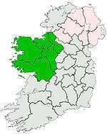 | |
| Dartry Mountains | ||
| Maumturks | ||
| Nephin Range | ||
| Ox Mountains | ||
| Partry Mountains | ||
| Sheeffry Range | ||
| Twelve Bens | ||
| Others | ||
Lists of Marilyns | |
|---|---|
This article is issued from Wikipedia - version of the 9/25/2016. The text is available under the Creative Commons Attribution/Share Alike but additional terms may apply for the media files.