Cowles Mountain
| Cowles Mountain | |
|---|---|
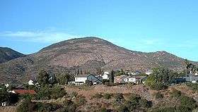 Cowles Mountain as seen from San Diego. A remnant of the "S" can be seen near the summit. | |
| Highest point | |
| Elevation | 1,593 ft (486 m) NAVD 88[1] |
| Prominence | 991 ft (302 m) [1] |
| Coordinates | 32°48′45″N 117°01′52″W / 32.8125497°N 117.0311403°WCoordinates: 32°48′45″N 117°01′52″W / 32.8125497°N 117.0311403°W [2] |
| Geography | |
| Location | San Diego County, California. |
| Topo map | USGS La Mesa |
| Climbing | |
| Easiest route | Trail |
Cowles Mountain (pronounced coals, not COWles)[3] is a prominent mountain located in the San Carlos neighborhood, within the City of San Diego, San Diego County, California. The 1,593-foot (486 m) summit is the highest point of the city of San Diego.
It is protected within Mission Trails Regional Park. While many people pronounce "Cowles" to rhyme with "towels," the pronunciation of the name should be like "Coals" as this is how George Cowles's family was known.[4][5]
History
The mountain is named after George A. Cowles, a 1870s-80s rancher and early businessperson in southwestern San Diego County.
San Diego State University
For many years Cowles Mountain was locally known as "S" Mountain. In 1931, 500 students from San Diego State University (SDSU) painted a 400-foot-tall (120 m) letter "S" on the side of the mountain, after which it took on its popular name.[6] In April 1942, during World War II, the local military ordered the S covered up for the sake of national security. After the war the painting tradition was resurrected.
In the 1970s, the annual repainting tradition was ceased for environmental and habitat protection, but suffered a brief resurgence in the late 1980s. The "S" has not been repainted for nearly two decades.
Mission Trails Regional Park
The entire mountain, with marked trails, is a protected area within Mission Trails Regional Park, which opened in 1972.
Trails
The main trail to the summit is a popular hiking destination taking hundreds of people per day to a 360-degree panorama of San Diego County. The hike to the top is 1.5 miles (2.4 km) long and an elevation change of about 950 feet (290 m). This trail is on the corner of Golfcrest Drive and Navajo Road. A much-less-used but maintained trail begins near the intersection of Boulder Lake Avenue and Barker way. This trail meets the main trail near the summit.
On March 25, 2013 the trails of Cowles were closed for maintenance.[7] The trails were reopened in May 2013 after several improvements to water drainage and rock steps.[4]
Geology

Cowles Mountain consists of Jurassic and early Cretaceous metavolcanic and shallow intrusive igneous rocks that are resistant to erosion, and never covered by later Cretaceous and Tertiary sedimentary overburden. Small plateaus on the south and east slopes are the remnants of an extensive terrestrial, near sea level erosional surface called the Poway Terrace that are now about 1,200 feet (370 m) in elevation.
A prominent former seacliff on the west side rises above a now-dry wave-cut terrace, now mostly covered with suburban developments, at about 600 feet (180 m) in elevation.
References
- 1 2 "Cowles Mountain, California". Peakbagger.com. Retrieved 2014-01-30.
- ↑ "Cowles Mountain". Geographic Names Information System. United States Geological Survey. Retrieved 2014-01-30.
- ↑ http://mtrp.org/aaapopups/trail_maps/pop_map_details.asp?area_idno=0&habitat_idno=0&trail_idno=3
- 1 2 Swain, Liz (2013-05-14). "Cowles Mountain trail repaired, ready to open on May 18". San Diego Reader. Archived from the original on 2014-05-31. Retrieved 2014-05-31.
- ↑ "History". Mission Trails Regional Park Online.
- ↑ "SDSU from A-Z". San Diego State University. Archived from the original on 2011-07-20. Retrieved 2011-07-20.
- ↑ Grieco, Sarah (2013-03-14). "Cowles Mountain to Temporarily Close". NBC San Diego. Archived from the original on 2014-05-31. Retrieved 2014-05-31.
External links
| Wikimedia Commons has media related to Cowles Mountain. |