Crater Lake
| Crater Lake | |
|---|---|
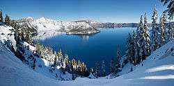 Panoramic winter view of Crater Lake from Rim Village | |
 Crater Lake  Crater Lake Location in the United States | |
 Bathymetric survey | |
| Location | Klamath County, Oregon |
| Coordinates | 42°57′N 122°06′W / 42.95°N 122.10°WCoordinates: 42°57′N 122°06′W / 42.95°N 122.10°W |
| Lake type | crater lake |
| Primary inflows | precipitation and snowmelt only |
| Primary outflows | evaporation, subsurface seepage to Wood River |
| Catchment area | 23.3 sq mi (60 km2) |
| Basin countries | United States |
| Max. length | 6 mi (9.7 km) |
| Max. width | 5 mi (8.0 km) |
| Surface area | 20.6 sq mi (53 km2) |
| Average depth | 1,148 ft (350 m) |
| Max. depth | 1,949 ft (594 m) |
| Water volume | 4.49 cu mi (18.7 km3) |
| Residence time | 157 years |
| Shore length1 | 21.8 mi (35.1 km) |
| Surface elevation | 6,178 ft (1,883 m) |
| Islands |
Wizard Island Phantom Ship |
| 1 Shore length is not a well-defined measure. | |
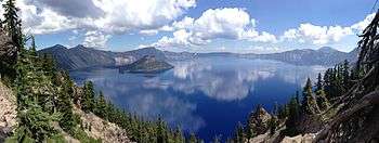
Crater Lake (Klamath: giiwas[1]) is a caldera lake in the western United States, located in south-central Oregon. It is the main feature of Crater Lake National Park and is famous for its deep blue color and water clarity. The lake partly fills a nearly 2,148-foot (655 m)-deep caldera[2] that was formed around 7,700 (± 150) years ago[3] by the collapse of the volcano Mount Mazama. There are no rivers flowing into or out of the lake; the evaporation is compensated for by rain and snowfall at a rate such that the total amount of water is replaced every 250 years. With a depth of 1,949 feet (594 m),[4] the lake is the deepest in the United States. In the world, it ranks tenth for maximum depth, and third for mean (average) depth.[5]
Crater Lake is also known for the "Old Man of the Lake", a full-sized tree which is now a stump that has been bobbing vertically in the lake for over a century.[6][7] The low temperature of the water has slowed the decomposition of the wood, hence the longevity of the bobbing tree.
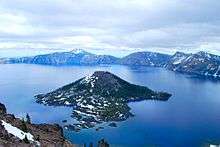
Two islands are in Crater Lake: Wizard Island, formed from a cinder cone that erupted after Crater Lake began to fill with water, and the smaller Phantom Ship, which has seven trees living on it. There are also colonies of violet-green swallows and several varieties of wildflowers and lichens living there.
While having no indigenous fish population, the lake was stocked from 1888 to 1941 with a variety of fish. Several species have formed self-sustaining populations.[8] Since 2002, one of the state's regular-issue license plate designs has featured Crater Lake.[9] The commemorative Oregon State Quarter, which was released by the United States Mint in 2005, features an image of Crater Lake on its reverse.[10]
Location
Crater Lake is located in Klamath County, approximately 60 miles (97 km) northwest of the county seat of Klamath Falls, and about 80 miles (130 km) northeast of the city of Medford.[11]
In June 1853, John Wesley Hillman became the first non-Native American explorer to report sighting the lake he named the "Deep Blue Lake." The lake was renamed at least three times, as Blue Lake, Lake Majesty, and finally Crater Lake.[12][13]
Dimensions and depth
The lake is 5 by 6 miles (8.0 by 9.7 km) across, with a caldera rim ranging in elevation from 7,000 to 8,000 feet (2,100 to 2,400 m) and an average lake depth of 1,148 feet (350 m). The lake's maximum depth has been measured at 1,949 feet (594 m),[4][2][14][15] which fluctuates slightly as the weather changes.[2] On the basis of maximum depth, Crater Lake is the deepest lake in the United States, the second-deepest in North America (after Great Slave Lake in Canada), and the tenth-deepest lake in the world (Lake Baikal is the deepest). Crater Lake is often cited as the seventh-deepest lake in the world, but this ranking excludes Lake Vostok in Antarctica,[16][17] which is situated under about 13,000 feet (4,000 m) of ice, and the recent soundings of O'Higgins/San Martín Lake, which is located on the border of Chile and Argentina.[18]
When considering the mean, or average depth of lakes, Crater Lake becomes the deepest lake in the Western Hemisphere and the third-deepest in the world. Crater Lake Institute Director and limnologist Owen Hoffman states "Crater Lake is the deepest, when compared on the basis of average depth among lakes whose basins are entirely above sea level. The average depths of Lakes Baikal and Tanganyika are deeper than Crater Lake; however, both have basins that extend below sea level."[17][19]
Geology
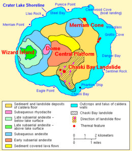
Mount Mazama, part of the Cascade Range volcanic arc, was built up mostly of andesite, dacite, and rhyodacite over a period of at least 400,000 years. The caldera was created in a massive volcanic eruption between 6,000 and 8,000 years ago that led to the subsidence of Mount Mazama. About 50 cubic kilometers (12 cu mi) of rhyodacite was erupted in this event. Since that time, all eruptions on Mazama have been confined to the caldera.[20][21]
Lava eruptions later created a central platform, Wizard Island, Merriam Cone, and other, smaller volcanic features, including a rhyodacite dome that was eventually created atop the central platform. Sediments and landslide debris also covered the caldera floor.[22]
Eventually, the caldera cooled, allowing rain and snow to accumulate and form a lake. Landslides from the caldera rim thereafter formed debris fans and turbidite sediments on the lake bed. Fumaroles and hot springs remained common and active during this period. Also after some time, the slopes of the lake's caldera rim more or less stabilized, streams restored a radial drainage pattern on the mountain, and dense forests began to revegetate the barren landscape. It is estimated that about 720 years was required to fill the lake to its present depth of 594 m (1,949 ft). Much of this occurred during a period when the prevailing climate was less moist than at present.[23]
Some hydrothermal activity remains along the lake floor, suggesting that at some time in the future Mazama may erupt once again.[24]
Climate
Crater Lake is a subalpine climate, with the rare dry-summer type (Köppen classification Dsc) owing to its high elevation and – like all of Oregon – the strong summer influence of the North Pacific High. In the summer, the weather is mild and dry, but in the winter is cold and the powerful influence of the Aleutian Low allows for enormous snowfalls averaging 488 inches (12.40 m) per year and maximum snow cover averaging 139 inches or 3.53 meters. This snow does not usually melt until mid-July, and allows for substantial glaciers on adjacent mountains. In the winter of 1949/1950 as much as 885.1 inches (22.48 m) of snow fell, whilst the less complete snow cover records show cover as high as 192 inches or 4.88 meters occurred during another particularly unsettled winter in 1981/1982.[25] The heaviest daily snowfall was 37.0 inches (94.0 cm), which occurred as recently as February 28, 1971; 20 in (51 cm) or more in one storm has occurred in both June and September. Hard frost is possible even into the summer, and the average window for freezing temperatures is August 19 through July 7, while for measurable (≥0.1 inches or 0.25 centimeters) snowfall, October 1 through June 15.
| Climate data for Crater Lake | |||||||||||||
|---|---|---|---|---|---|---|---|---|---|---|---|---|---|
| Month | Jan | Feb | Mar | Apr | May | Jun | Jul | Aug | Sep | Oct | Nov | Dec | Year |
| Record high °F (°C) | 64 (18) |
66 (19) |
67 (19) |
71 (22) |
80 (27) |
95 (35) |
100 (38) |
94 (34) |
93 (34) |
81 (27) |
71 (22) |
64 (18) |
100 (38) |
| Average high °F (°C) | 33.8 (1) |
35.2 (1.8) |
37.3 (2.9) |
42.8 (6) |
50.5 (10.3) |
58.6 (14.8) |
69.6 (20.9) |
69.6 (20.9) |
63.0 (17.2) |
52.0 (11.1) |
40.1 (4.5) |
34.6 (1.4) |
48.93 (9.4) |
| Daily mean °F (°C) | 25.8 (−3.4) |
26.8 (−2.9) |
28.3 (−2.1) |
32.6 (0.3) |
39.4 (4.1) |
46.3 (7.9) |
55.2 (12.9) |
55.1 (12.8) |
49.7 (9.8) |
41.2 (5.1) |
31.8 (−0.1) |
26.8 (−2.9) |
38.25 (3.46) |
| Average low °F (°C) | 17.7 (−7.9) |
18.3 (−7.6) |
19.2 (−7.1) |
22.3 (−5.4) |
28.2 (−2.1) |
33.9 (1.1) |
40.7 (4.8) |
40.6 (4.8) |
36.3 (2.4) |
30.3 (−0.9) |
23.4 (−4.8) |
19.0 (−7.2) |
27.49 (−2.49) |
| Record low °F (°C) | −21 (−29) |
−18 (−28) |
−7 (−22) |
−3 (−19) |
5 (−15) |
10 (−12) |
18 (−8) |
23 (−5) |
16 (−9) |
3 (−16) |
−7 (−22) |
−18 (−28) |
−21 (−29) |
| Average precipitation inches (mm) | 10.20 (259.1) |
7.93 (201.4) |
7.74 (196.6) |
4.96 (126) |
3.22 (81.8) |
2.31 (58.7) |
0.75 (19) |
0.95 (24.1) |
2.08 (52.8) |
1.94 (49.3) |
9.25 (235) |
11.14 (283) |
62.47 (1,586.8) |
| Average snowfall inches (cm) | 96.2 (244.3) |
82.0 (208.3) |
82.2 (208.8) |
45.3 (115.1) |
19.7 (50) |
3.9 (9.9) |
0.2 (0.5) |
0.1 (0.3) |
2.8 (7.1) |
21.4 (54.4) |
60.8 (154.4) |
90.4 (229.6) |
505 (1,282.7) |
| Source: Western Regional Climate Center[26] | |||||||||||||
Water quality
Due to several unique factors, mainly that the lake has no inlets or tributaries, the waters of Crater Lake are some of the purest in the world because of the absence of pollutants. Clarity readings from a Secchi disk have consistently been in the high-30 meter to mid-20 meter (80 to 115-foot) range, which is very clear for any natural body of water. In 1997, scientists recorded a record clarity of 53.3 m (175 ft).
The lake has relatively high levels of dissolved salts, total alkalinity, and conductivity. The average pH has generally ranged between 7 and 8.[27]
Sacred significance
The Klamath tribe of Native Americans, whose ancestors may have witnessed the collapse of Mount Mazama and the formation of Crater Lake, have long regarded the lake as a sacred site. Their legends tell of a battle between the sky god Skell and the god of the underworld Llao. Mount Mazama was destroyed in the battle, creating Crater Lake, called giiwas in the Klamath language.[1] The Klamath people used Crater Lake in vision quests, which often involved climbing the caldera walls and other dangerous tasks. Those who were successful in such quests were often regarded as having more spiritual powers. The tribe still holds Crater Lake in high regard as a spiritual site.[28][29]
See also
Notes
- 1 2 "Klamath Tribes Language Project". The Klamath Tribes. 2012. Retrieved March 21, 2016.
- 1 2 3 "Facts about Crater Lake". Oregon Explorer. Oregon State University. Retrieved 2009-02-05.
- ↑ "Crater Lake". Global Volcanism Program. Smithsonian Institution. Retrieved 2008-12-18.
- 1 2 Bacon, CR; Gardner, JV; Mayer, LA; Buktnenica, MW; et al. (June 2002). "Morphology, volcanism, and mass wasting in Crater Lake, Oregon" (PDF). GSA Bulletin. 114 (6): 675–692. Bibcode:2002GSAB..114..675B. doi:10.1130/0016-7606(2002)114<0675:mvamwi>2.0.co;2.
- ↑ See further details in the prose and citations of #Dimensions and depth.
- ↑ Kartchnerand, W.E.; Doerr, J.E., Jr. (September 1938). "Wind Currents In Crater Lake As Revealed By The Old Man Of The Lake". Nature Notes from Crater Lake National Park. XI (3). Archived from the original on 2008-06-11.
- ↑ "On the Trail The Old man of Crater Lake" (Video). CBS News. October 9, 2016. Retrieved October 9, 2016.
- ↑ "The Fish of Crater Lake". National Park Service. Archived from the original on 2010-02-21.
- ↑ Goetze, Janet (August 26, 2002). "Crater Lake plates aglow with color". The Oregonian. Portland, Oregon. p. B4.
- ↑ "The Oregon Quarter: The United States Mint". U.S. Department of the Treasury. Retrieved 2007-06-29.
- ↑ "Crater Lake National Park: Directions". National Park Service. Retrieved 2009-12-10.
- ↑ Tilden, Freeman (1968). The National Parks. New York: Alfred A. Knopf.
- ↑ Runkel, H.J. (1953). "Crater Lake Discovery Centennial". Nature Notes from Crater Lake National Park. XIX. Archived from the original on 2008-12-04.
- ↑ Andalkar, Amar (2003-12-18). "Crater Lake (Mount Mazama)". Skiing the Cascade Volcanoes. skimountaineer.com. Retrieved 2013-07-08.
- ↑ Gibbons, Helen (September 2000). "CMG Maps Bottom of Crater Lake, Oregon". U.S. Geological Survey. Retrieved 2010-05-16.
- ↑ Evans, C.T. (2007). "Lake Baikal". Northern Virginia Community College. Retrieved 2013-07-08.
- 1 2 Juillerat, Lee (2007-11-29). "Into the Deep: Crater Lake's ranking as one of the world's deepest lakes varies by how list is determined". Herald and News. Klamath Falls, Oregon. Retrieved 2013-07-08.
- ↑ Jaros, Garret (2010-03-16). "A snowshoe view: Take a ranger-guided winter trek around snowy Crater Lake" (Oregon Life section). The Register-Guard. Eugene, Oregon. p. D1. Retrieved 2013-07-08.
- ↑ Repanshek, Kurt; Hoffman, Owen (2007-11-14). "Crater Lake, On Average, Is Deepest Lake in North America" (see story comments as well). National Parks Traveler. Retrieved 2013-07-08.
- ↑ Topinka, Lyn (2008-04-18). "Mount Mazama Volcano and Crater Lake Caldera, Oregon". Cascades Volcano Observatory. U.S. Geological Survey. Retrieved 2013-07-08.
- ↑ Jewell and McRae, p. 571
- ↑ Bacon, Charles R; James V. Gardner; Larry A. Mayer; Mark W. Buktenica; Peter Dartnell; David W. Ramsey; Joel E. Robinson (2002). "Morphology, volcanism, and mass wasting in Crater Lake, Oregon". Geological Society of America Bulletin. 114 (6): 675–692. Bibcode:2002GSAB..114..675B. doi:10.1130/0016-7606(2002)114<0675:MVAMWI>2.0.CO;2.
- ↑ Nathenson, Manuel; Charles R. Bacon; David W. Ramsey (2007). "Subaqueous geology and a filling model for Crater Lake, Oregon". Hydrobiologia. 574: 13–27. doi:10.1007/s10750-006-0343-5.
- ↑ "Geologic History of Crater Lake". Oregon Explorer. Oregon State University. Retrieved 2009-02-05.
- ↑ National Oceanic and Atmospheric Administration; Climate at a Glance: Oregon Climate Division 5 (High Plateau) October to June Precipitation
- ↑ "CRATER LAKE NPS HQ, OREGON (351946)". Western Regional Climate Center. Retrieved June 12, 2016.
- ↑ "Facts and Figures about Crater Lake" (PDF). U.S. National Park Service. Archived from the original (PDF) on 2012-01-03. Retrieved 2012-01-03.
- ↑ "Park History" (PDF). National Park Service. Archived from the original (PDF) on 2012-01-03. Retrieved 2012-01-03.
- ↑ "Crater Lake as Sacred Site". Sacred Destinations. Archived from the original on 2009-06-02.
References
- Fire Mountains of the West: The Cascade and Mono Lake Volcanoes, Stephen L. Harris, (Mountain Press Publishing Company, Missoula; 1988) ISBN 0-87842-220-X
- Geology of National Parks: Fifth Edition, Ann G. Harris, Esther Tuttle, Sherwood D. Tuttle, (Iowa, Kendall/Hunt Publishing; 1997) ISBN 0-7872-5353-7
- Bacon, Charles R.; Lanphere, Marvin A. (2006). "Eruptive history and geochronology of Mount Mazama and the Crater Lake region, Oregon". Geological Society of American Bulletin. 118 (11–12): 1331–1359. Bibcode:2006GSAB..118.1331B. doi:10.1130/B25906.1.
- Oregon, Moon Handbooks, Judy Jewell, W. C. McRae, (Avalon Travel, Berkeley; 2012, 9th edition) ISBN 978-1-59880-885-8
External links
| Wikimedia Commons has media related to Crater Lake. |
- NPS: Crater Lake National Park
- USGS: Crater Lake Data Clearinghouse
- Oregon Institute of Technology: Crater Lake Digital Research Collection