Crawford County, Wisconsin
| Crawford County, Wisconsin | |
|---|---|
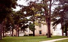 Crawford County Courthouse | |
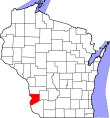 Location in the U.S. state of Wisconsin | |
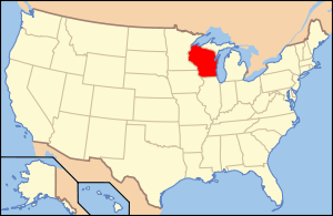 Wisconsin's location in the U.S. | |
| Founded | 1818 |
| Named for | William H. Crawford |
| Seat | Prairie du Chien |
| Largest city | Prairie du Chien |
| Area | |
| • Total | 599 sq mi (1,551 km2) |
| • Land | 571 sq mi (1,479 km2) |
| • Water | 29 sq mi (75 km2), 4.8% |
| Population | |
| • (2010) | 16,644 |
| • Density | 29/sq mi (11/km²) |
| Congressional district | 3rd |
| Time zone | Central: UTC-6/-5 |
| Website |
www |
Crawford County is a county in the southwest part of the U.S. state of Wisconsin. As of the 2010 census, the population was 16,644.[1] Its county seat is Prairie du Chien.[2]
History
Along with Brown County, Crawford County is one of Wisconsin's original counties, established by the Michigan Territorial legislature in 1818, and named after William H. Crawford,[3] James Monroe's Treasurer at the time. It originally covered the western half of Wisconsin's present area. In 1836, it was transferred to the newly formed Wisconsin Territory as Michigan prepared for statehood and has gradually been subdivided into its present area.
Geography
According to the U.S. Census Bureau, the county has an area of 599 square miles (1,550 km2), of which 571 square miles (1,480 km2) is land and 29 square miles (75 km2) (4.8%) is water.[4] The county's highest hoint is near St. James Church in Rising Sun.
Three rivers run through the county: The Kickapoo River, nicknamed "the crookedest river in Wisconsin" was carved out by glacial run-off. It is considered one of the best Class 1 paddling rivers in the Midwest.
- The Wisconsin River borders the county's southern edge. Although it is the state's busiest river, its run within the county is tranquil, with high bluff escarpments and sandy islands.
- The Mississippi River, serves as the county's western border. The steep limestone cliffs are interspersed with bluffs and prairies.
Adjacent counties
- Vernon County - north
- Richland County - east
- Grant County - south
- Clayton County, Iowa - southwest
- Allamakee County, Iowa - west
Demographics
| Historical population | |||
|---|---|---|---|
| Census | Pop. | %± | |
| 1840 | 1,502 | — | |
| 1850 | 2,498 | 66.3% | |
| 1860 | 8,068 | 223.0% | |
| 1870 | 13,075 | 62.1% | |
| 1880 | 15,644 | 19.6% | |
| 1890 | 15,987 | 2.2% | |
| 1900 | 17,286 | 8.1% | |
| 1910 | 16,288 | −5.8% | |
| 1920 | 16,772 | 3.0% | |
| 1930 | 16,781 | 0.1% | |
| 1940 | 18,328 | 9.2% | |
| 1950 | 17,652 | −3.7% | |
| 1960 | 16,351 | −7.4% | |
| 1970 | 15,252 | −6.7% | |
| 1980 | 16,556 | 8.5% | |
| 1990 | 15,940 | −3.7% | |
| 2000 | 17,243 | 8.2% | |
| 2010 | 16,644 | −3.5% | |
| Est. 2015 | 16,391 | [5] | −1.5% |
| U.S. Decennial Census[6] 1790–1960[7] 1900–1990[8] 1990–2000[9] 2010–2014[1] | |||
As of the census[10] of 2010, there were 16,644 people, 6,677 households, and 4,613 families residing in the county. The population density was 12/km² (30/sq mi). There were 8,480 housing units at an average density of 6/km² (15/sq mi). The racial makeup of the county was 96.61% White, 1.78% Black or African American, 0.23% Native American, 0.38% Asian, 0.01% Pacific Islander, 0.17% from other races, and 0.68% from two or more races. 0.9% of the population were Hispanic or Latino of any race. 33.6% were of German, 16.0% Norwegian, 11.4% Irish, 7.2% Czech, 7.2% English and 6.4% United States or American ancestry.
There were 6,677 households out of which 31.60% had children under the age of 18 living with them, 56.70% were married couples living together, 8.40% had a female householder with no husband present, and 30.90% were non-families. 26.70% of all households were made up of individuals and 13.00% had someone living alone who was 65 years of age or older. The average household size was 2.48 and the average family size was 3.00.
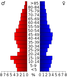
In the county, the population was spread out with 24.25% under the age of 20, 8.10% from 18 to 24, 26.20% from 20 to 44, 31.16% from 45 to 64, and 18.40% who were 65 years of age or older. The median age was 39 years. For every 100 females there were 102.20 males. For every 100 females age 18 and over, there were 99.30 males.
Transportation
Major highways
Airport
Prairie du Chien Municipal Airport (KPDC) serves Crawford County and the surrounding communities.
Communities
Cities
- Prairie du Chien (county seat)
Villages
Towns
Unincorporated communities
See also
- National Register of Historic Places listings in Crawford County, Wisconsin
- Upper Mississippi River National Wildlife and Fish Refuge
References
- 1 2 "State & County QuickFacts". United States Census Bureau. Retrieved January 18, 2014.
- ↑ "Find a County". National Association of Counties. Archived from the original on 2011-05-31. Retrieved 2011-06-07.
- ↑ Gannett, Henry (1905). The Origin of Certain Place Names in the United States. Govt. Print. Off. p. 95.
- ↑ "2010 Census Gazetteer Files". United States Census Bureau. August 22, 2012. Retrieved August 2, 2015.
- ↑ "County Totals Dataset: Population, Population Change and Estimated Components of Population Change: April 1, 2010 to July 1, 2015". Retrieved July 2, 2016.
- ↑ "U.S. Decennial Census". United States Census Bureau. Archived from the original on May 11, 2015. Retrieved August 2, 2015.
- ↑ "Historical Census Browser". University of Virginia Library. Retrieved August 2, 2015.
- ↑ Forstall, Richard L., ed. (March 27, 1995). "Population of Counties by Decennial Census: 1900 to 1990". United States Census Bureau. Retrieved August 2, 2015.
- ↑ "Census 2000 PHC-T-4. Ranking Tables for Counties: 1990 and 2000" (PDF). United States Census Bureau. April 2, 2001. Retrieved August 2, 2015.
- ↑ "American FactFinder". United States Census Bureau. Archived from the original on 2013-09-11. Retrieved 2011-05-14.
Further reading
- History of Crawford and Richland Counties, Wisconsin. Springfield, Ill.: Union Publishing Company, 1884.
External links
- Official Crawford County website
- Crawford County map at the Wisconsin Department of Transportation
- Crawford County Health and Demographic Data
 |
Vernon County | | ||
| Allamakee County, Iowa | |
Richland County | ||
| ||||
| | ||||
| Clayton County, Iowa | Grant County |
Municipalities and communities of Crawford County, Wisconsin, United States | ||
|---|---|---|
| City | | |
| Villages | ||
| Towns | ||
| Unincorporated communities | ||
| Footnotes | ‡This populated place also has portions in an adjacent county or counties | |
Coordinates: 43°14′N 90°56′W / 43.23°N 90.93°W