Cross County Parkway
| |
|---|---|
|
Map of Westchester County in southeastern New York with Cross County Parkway highlighted in red | |
| Route information | |
| Maintained by NYSDOT | |
| Length: | 4.46 mi[1] (7.18 km) |
| Existed: | 1947 – present |
| Restrictions: | No commercial vehicles |
| Major junctions | |
| West end: |
|
| |
| East end: |
|
| Location | |
| Counties: | Westchester |
| Highway system | |

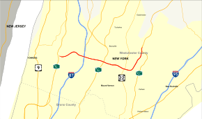
The Cross County Parkway (CCP) is a 4.46-mile-long (7.18 km) parkway in lower Westchester County, New York, in the United States. The parkway is a critical east–west connection throughout Westchester, having full interchanges with every major north–south highway in southern Westchester with the exception of the New England Thruway. Among its junctions, it has access to the New York State Thruway mainline. The western terminus is at the Saw Mill River Parkway in Yonkers. The eastern terminus is at the Hutchinson River Parkway in Eastchester.
As evident from stubs and oversized overpasses, it appears that there were plans to expand the Parkway west from exit 3 and east from exit 9, respectively.[2] World War II had slowed this idea until it was shelved. The CCP is the only parkway in New York state that has express and local lanes. The parkway is designated New York State Route 907K (NY 907K), an unsigned reference route.
Route description
The Cross County Parkway begins at an interchange with the Saw Mill River Parkway (exit 4A) in Yonkers. On the ramp for the southbound Saw Mill River Parkway, it has a left lane which leads to a ramp onto Rumsey Road, this called exit one (Going westbound this is designated exit 2 for the Cross County and exit 1 for Rumsey Road). After crossing an abandoned railroad grade, the parkway enters exit 3, a small interchange with Yonkers Avenue. The six-lane roadway crosses through southeast Yonkers, making a gradual bend from the northeast to the southeast before crossing into an interchange with the New York State Thruway (I-87) and NY 100. In this interchange, designated as exits 4S and 4N, eastbound are accessed by separate ramps on frontage roads. Just east of the Thruway, the Cross County passes north of Cross County Shopping Center and the frontage roads service exit 5, which connects to Kimball Avenue and Midland Avenue.[3]
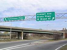
Continuing east through Yonkers, the Cross County Parkway enters an interchange with the Bronx River Parkway just south of the fork from the Sprain Brook Parkway. In the center of this interchange, consisting of several flyover ramps, is the Fleetwood Metro-North Railroad station on the Harlem Line. Now in Mount Vernon, the parkway enters an urbanized part of the city before winding southeast into the Chester Heights section, where it enters exit 8 for NY 22 (North Columbus Avenue). Just east of exit 8, the Cross County has a ramp for exit 9, which connects the parkway to the southbound lanes of the Hutchinson River Parkway at the latter's exit 13. At this interchange, the Cross County Parkway turns northward, paralleling a park in Chester Heights and entering exit 10, a small interchange with New Rochelle Road.[3]
Now in Eastchester, the Cross County Parkway continues north as a six-lane parkway before crossing under a flyover ramp for the Hutchinson River Parkway southbound and merging into the parkway northbound.[3]
History
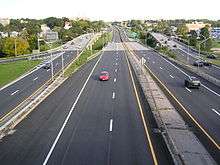
The Cross County Parkway was originally built as an east–west link between the Saw Mill, Bronx River, and Hutchinson River Parkways. Construction began in 1929, and the highway was initially a 40-foot (12 m)-wide undivided roadway that could accommodate four lanes of automobile traffic (two in each direction). The parkway had a toll barrier in Fleetwood, which was removed in the early 1950s. The reconstruction of the Cross County Parkway was begun in 1964; however, the project was not completed until 1984[4][5] The parkway is now a multi-lane highway with express and local lanes. In conjunction with the renovation of the Cross County Shopping Center, Exit 5 westbound and Exit 5 eastbound of the Cross County Parkway underwent major reconstruction during 2010 and 2011. The two exit ramps were widened and improved with new traffic lights and signage. In addition, traffic can now proceed directly from the eastbound parkway into the shopping center.
Cross County Parkway was originally intended to connect to the Rye Playland Parkway.[6] However this proposal was stalled by the Great Depression and Second World War, and finally cancelled in the 1970s.
Exit list
The entire route is in Westchester County.
| Location | mi[1][7] | km | Exit | Destinations | Notes | |
|---|---|---|---|---|---|---|
| Yonkers | 0.00 | 0.00 | – | Exit 4A on Saw Mill Parkway | ||
| 0.20 | 0.32 | 1 | Rumsey Road | Westbound exit and eastbound entrance | ||
| 0.40 | 0.64 | 2 | Westbound exit and eastbound entrance | |||
| 0.75 | 1.21 | 3 | Yonkers Avenue | No westbound entrance | ||
| 1.20 | 1.93 | West end of local/express lane division | ||||
| 1.60 | 2.57 | 4 | Signed as exits 4S (south) and 4N (north); exit 4 on I-87 / Thruway; all but eastbound exit 4N access via local lanes | |||
| 2.10 | 3.38 | 5 | Kimball Avenue / Midland Avenue | Access via local lanes; no eastbound entrance | ||
| 2.40 | 3.86 | East end of local/express lane division (westbound) | ||||
| 2.50 | 4.02 | 6 | Access via local lanes (except westbound exit); exit 11 on Bronx Parkway | |||
| Mount Vernon | 2.60 | 4.18 | 7 | West Broad Street / Gramatan Avenue | Eastbound exit and entrance from local lanes | |
| 2.80 | 4.51 | East end of local/express lane division (eastbound) | ||||
| 3.50 | 5.63 | 8 | ||||
| 3.70 | 5.95 | 9 | Eastbound exit and westbound entrance; exit 13 on Hutchinson Parkway | |||
| 4.20 | 6.76 | 10 | New Rochelle Road – Eastchester | Eastbound exit and westbound entrance | ||
| Eastchester | 5.50 | 8.85 | – | Exit 15 on Hutchinson Parkway | ||
| 1.000 mi = 1.609 km; 1.000 km = 0.621 mi | ||||||
See also
.svg.png) New York Roads portal
New York Roads portal
References
- 1 2 "2007 Traffic Data Report for New York State" (PDF). New York State Department of Transportation. July 25, 2008. Retrieved July 17, 2009.
- ↑ Anderson, Steve. "Cross County Parkway". NYCRoads. Retrieved March 18, 2010.
- 1 2 3 Microsoft; Nokia (October 4, 2012). "overview map of the Cross County Parkway" (Map). Bing Maps. Microsoft. Retrieved October 4, 2012.
- ↑ Fleetwood NYC Station, Mount Vernon, New York; 1954 (NETR Online; Historic Aerials)
- ↑ Fleetwood PC Station, Mount Vernon, New York; 1974 (NETR Online; Historic Aerials)
- ↑ "Transportation 1985: A Regional Plan," by the Tri-State Transportation Commission (1966)
- ↑ Google (January 9, 2016). "Cross County Parkway" (Map). Google Maps. Google. Retrieved January 9, 2016.
External links
| Wikimedia Commons has media related to Cross County Parkway. |
- Cross County Parkway at Alps' Roads • New York State Highway Termini