Curtiss Bay
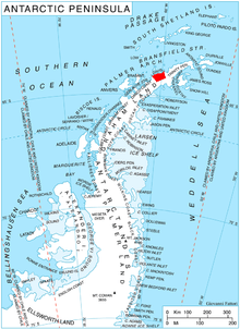
Curtiss Bay (64°2′S 60°47′W / 64.033°S 60.783°WCoordinates: 64°2′S 60°47′W / 64.033°S 60.783°W) is a bay about 4 nautical miles (7 km) wide, indenting the west coast of Graham Land just north of the Chavdar Peninsula, and entered between Cape Sterneck and Cape Andreas on the Davis Coast. Its head is fed by Samodiva Glacier, Pirin Glacier and Tumba Ice Cap.
The name Bahia Inutil (useless bay) appearing on a 1957 Argentine chart is considered misleading; the bay has been used as an anchorage. The bay was renamed by the UK Antarctic Place-Names Committee in 1960 for Glenn Curtiss, an American aeronautical engineer who pioneered seaplanes from 1911 onward.[1]
References
- ↑ "Curtiss Bay". Geographic Names Information System. United States Geological Survey. Retrieved 2011-12-11.
![]() This article incorporates public domain material from the United States Geological Survey document "Curtiss Bay" (content from the Geographic Names Information System).
This article incorporates public domain material from the United States Geological Survey document "Curtiss Bay" (content from the Geographic Names Information System).