Cyclone Qendresa
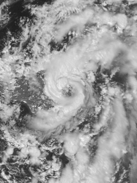 Qendresa near Sicily early on 8 November | |
| Type | Mediterranean tropical-like cyclone |
|---|---|
| Formed | 6 November 2014 |
| Dissipated | 9 November 2014 |
| Lowest pressure | 978 hPa (28.88 inHg) |
| Highest winds | |
| Highest gust | 153.7 km/h (95.5 mph; 83.0 kn) |
| Damage | Unknown |
| Areas affected | Libya, Tunisia, Italy, Malta, Greece |
Cyclone Qendresa (also known as Medicane Qendresa) was one of the most intense Mediterranean tropical-like cyclones on record, which struck Malta and the Italian island of Sicily in 2014. The storm formed on 6 November and rapidly intensified on 7 November due to a cold-core low aloft. Qendresa directly hit Malta in the afternoon and then crossed the eastern coast of Sicily on 8 November. Later, the cyclone weakened significantly and dissipated west of Crete on 9 November.
Meteorological history
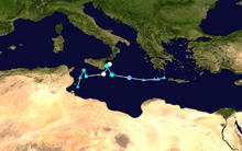
A shortwave trough near the British Isles started to expand southwards to North Africa since 3 November, which caused Lake Maggiore to overflow.[1][2] Although the Institute of Meteorology of the Free University of Berlin had assigned the name Qendresa to an expected low-pressure area developed within the trough on 4 November, it actually gave the name to two different systems on 5 November, resulting in Qendresa I to the south and Qendresa II to the north.[3] On 6 November, the southern tip of Qendresa I started to develop a low-level circulation centre (LLCC) near Kerkennah Islands, and it is referred to simply as Qendresa later by most of documents and reports. The trough also developed two upper-level circulation centres (ULCCs) on the same day— the one near the southeastern coast of France quickly dissipated, yet the one in Algeria moved to Tunisia and then entered the Strait of Sicily on the next day, becoming a cut-off low from the trough.[4]
When Qendresa’s LLCC was moving north-northeastwards and combining with the ULCC early on 7 November, the system occluded quickly and intensified dramatically.[4] Thanks to sea surface temperature over 23 ºC and the strong cold air at middle and upper levels, Qendresa formed an eye-like feature surrounded by deep convection near Linosa around noon.[5][2] Shortly before 17:00 CET (16:00 UTC), Qendresa directly hit Malta when it had lost its fronts with a more well-defined eye.[4] MOLOCH, an Italian model, estimated that the low-level temperature of Qendresa’s eye was about 6 ºC warmer than the surrounding area with the no longer cold middle and upper levels at that time, suggesting a warm-core system.[6] Interacting with Sicily, the cyclone turned northeastwards and started to make an anticlockwise loop east of the Italian island.[4] On 8 November, Qendresa tracked along the coast of Catania and crossed Syracuse in the morning. It was significantly eroded because of the terrain of Sicily and increasing vertical wind shear, resulting a partially exposed and weakening system later.[4] Turning southeastwards then moving eastwards, Qendresa dissipated as a remnant low west of Crete in the evening on 9 November.[7]
Impact

Malta experienced a direct hit similar to a typical tropical cyclone from Qendresa. In St. Paul's Bay, a coastal town in northern Malta, the weather station of Buġibba recored ten-minute sustained winds at 110.9 km/h (68.9 mph) and the gust at 153.7 km/h (95.5 mph) at 16:58 CET (15:58 UTC), the strongest recorded overland from a Mediterranean tropical-like cyclone in history; about 15 minutes later, the central pressure at 978.6 hPa (28.90 inHg) was recorded inside the eye with totally calm conditions, the lowest of all Mediterranean tropical-like cyclones since reliable records. Weather stations across other areas also recorded significant gusts from Qendresa. At Malta International Airport, it recorded the gust at 119 km/h (73.9 mph). Lampedusa, the largest island of the Italian Pelagie Islands, recorded the gust at 135 km/h (83.9 mph).[2]
Qendresa caused chaos in Malta. Airport operations were suspended, and harbours were also closed. With lots of cars stalled in flooded streets throughout low-lying areas, the cyclone caused a traffic nightmare over the island. Power outages happened in several towns as electricity poles were brought down by strong winds; besides, many trees were uprooted.[8] Qendresa brought similar damages to the eastern part of Sicily, including eroded coasts, blew off roofs and overturned boats.[9]
See also
References
- ↑ "Archiv-Version des Animationstools" (in German). Wetter3. Retrieved 1 November 2016.
- 1 2 3 "A Medicane (MEDIterranean hurriCANE) or Tropical-Like Cyclone (TLC) brought severe weather to parts of the Mediterranean in early November.". EUMETSAT. 8 November 2014. Retrieved 5 November 2016.
- ↑ "Weather Chart" (GIF) (in German). Free University of Berlin. 5 November 2014. Retrieved 1 November 2016.
- 1 2 3 4 5 Sachweh, Michael (7 January 2015). "Qendresa - ein bemerkenswerter Medicane" (PDF) (in German). Munich: Free University of Berlin. Retrieved 1 November 2016.
- ↑ "ODYSSEA Mediterranean Sea Surface Temperature Analysis, daily, 0.02° resolution". IFREMER.
- ↑ "MOLOCH forecasts". CNR-ISAC. Retrieved 1 November 2016.
- ↑ "Weather Chart" (GIF) (in German). Free University of Berlin. 9 November 2014. Retrieved 4 November 2016.
- ↑ "Update 3: Airport operations resume, several areas without power, cars damaged as fierce storm lashes Malta". Times of Malta. 7 November 2014. Retrieved 5 November 2016.
- ↑ "Ciclone mediterraneo 7-8 novembre 2014" (in Italian). YouReport.it. Retrieved 5 November 2016.
External links
| Wikimedia Commons has media related to Cyclone Qendresa. |
- The Birth and Death of Medicane QENDRESA
- Medicane Qendresa Hits Malta And Sicily
- Ciclone mediterraneo 7-8 novembre 2014 from YouReport.it (Italian)