Daral Lake
| Daral Lake | |
|---|---|
 Daral Lake | |
| Location | Bahrain, Swat Valley |
| Coordinates | 35°13′01″N 72°22′30″E / 35.217°N 72.375°ECoordinates: 35°13′01″N 72°22′30″E / 35.217°N 72.375°E |
| Lake type | Alpine/Glacial lake |
| Primary inflows | Glacial water |
| Primary outflows | Daral khwar |
| Basin countries | Pakistan |
| Surface elevation | 3,505.2 m (11,500 ft) |
| Settlements | Bahrain town |
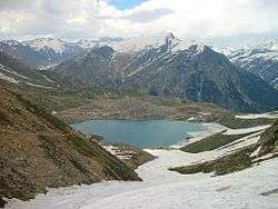
Daral lake also called as Daral Dand in Pashto, is an alpine scenic lake in the hill top of Bahrain region of Swat valley. The lake appears as giant amoeba like in shape and stretched over a huge area.
Near the lake, there is an ancient mosque where shepherds and visitors say their prayers and use as a resting place for night.
Location & Physical features

Daral Lake is situated in the western upper reaches of Bahrain, in the foothills of Spinsar Mountain and to the northeast of Saidgai Lake at an elevation of 3,505.2 m (11,500 ft). The lake is fed by melting glaciers of the surrounding mountains and gives rise to Daral Khwar which is the main left tributary of Swat River.
Access
Daral Lake is accessible only during the summer; during the winter, the trails which lead to the lake, are closed due to heavy snowfall. While in summer, it can be accessed from Bahrain in three to four hours of trekking on bare mountains, after which the trek descends down towards the East where Daral Lake is located. Alternatively, it can be approached from Gabina Jabba hill top, the most favoured trail. An unmetalled-cum-jeepable road ends at Gabina Jabba where the trekking journey begins. From here, continuous trekking for almost 4–5 hours leads to the lake.[1]
See also
- Lake Saiful Muluk - Kaghan Valley
- Dudipatsar Lake - Kaghan Valley
- Saidgai Lake - Swat Valley
- Mahodand Lake - Kalam Valley
- Kundol Lake - Kalam Valley
References
| Wikimedia Commons has media related to Daral lake. |