Dark Canyon Wilderness
| Dark Canyon Wilderness | |
|---|---|
|
IUCN category Ib (wilderness area) | |
 | |
 | |
| Location | San Juan County, Utah, USA |
| Nearest city | Monticello, Utah |
| Coordinates | 37°46′35″N 109°53′51″W / 37.7763793°N 109.8976330°WCoordinates: 37°46′35″N 109°53′51″W / 37.7763793°N 109.8976330°W |
| Area | 47,116 acres (19,067 ha) |
| Established | September 18, 1984 |
| Governing body | U.S. Forest Service |
Dark Canyon Wilderness, in the heart of southeast Utah's canyon country, is named for its high steep walls that narrow in the lower section so that they block the light in the morning and late afternoon.[1] The roughly horseshoe-shaped wilderness is made up of the upper part of 40-mile (64 km) long Dark Canyon and two major tributaries, Woodenshoe Canyon and Peavine Canyon in the Manti-La Sal National Forest. These canyons all descend from pine-covered Elk Ridge northeast of Natural Bridges National Monument. Dark Canyon continues west within a U.S. Bureau of Land Management primitive area that is recommended for wilderness designation. The last four miles of the main canyon drop steeply through Glen Canyon National Recreation Area into Lake Powell.
Life zones range from ponderosa pine and aspen-covered high country to desert vegetation in the bottom of Dark Canyon. High terraced castle-like sandstone walls tower 3,000 feet (910 m) above the canyon floors. Wildlife species include mule deer, some mountain lions, black bear and bighorn sheep. This diverse canyon country contains arches, springs, seeps and hanging gardens.
Water sources in Dark Canyon are often widely separated, and some have dried up entirely in recent drought years. Thunderstorms can result in powerful flash floods that scour the canyon streambeds.
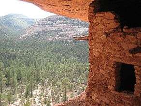
Wilderness visitors may see evidence of the Ancestral Puebloan culture.
All the trails dropping into the canyons are moderate but they can be difficult, if not impossible, to find and follow until you reach the bottoms of the canyons. Peavine Canyon contains a cherry-stem jeep trail. The Forest Service once recommended closing the area to vehicles but this corridor was kept open as a compromise in the Utah Wilderness Act of 1984.
See also
References
- ↑ "Dark Canyon Wilderness". Geographic Names Information System. United States Geological Survey. Retrieved 2008-11-00. Check date values in:
|access-date=(help)
External links
-
 Media related to Dark Canyon Wilderness at Wikimedia Commons
 - "Dark Canyon Wilderness". The National Wilderness Preservation System. Wilderness.net. Retrieved 2008-11-27.