Dark Divide

The Dark Divide is the largest roadless area in western Washington state, comprising approximately 76,000 acres (310 km²) of intact wilderness on Juniper Ridge linking Mount Saint Helens and Mount Adams in the southern Cascade Mountains of Washington. In two remote valleys of the Lewis River drainage are 500-year-old trees much coveted by timber companies, which successfully lobbied Congress to omit the Dark Divide from protection in the Washington Wilderness Act of 1984. Today those ancient forests are protected from logging as reserves for the northern spotted owl and other species under the Northwest Forest Plan. The area's recreational-use regulations however are disputed by advocates for hikers and wildlife, since it is currently the only sub-alpine area in Washington open to motorcycles.
Downstream of the confluence of Quartz Creek, the Lewis River plunges over four large waterfalls. Curly Creek, another tributary, is the only cataract in Washington with an intact natural stone bridge, and the early formation of a second natural bridge can be observed.
Although the Dark Divide is largely composed of black basalt, features such as 5,238-foot Dark Mountain, Dark Creek and Dark Meadows are actually named for John Dark, a 19th-century gold prospector and speculator.
Gallery
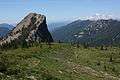 A rock outcropping immediately north of the summit of Jumbo Peak with Mount Rainier in the background
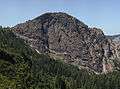 Rock outcropping on slopes of Jumbo Peak
 Pale bellflower Campanula scouleri
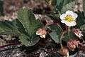 Virginia strawberry Fragaria virginiana
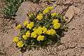 Sulphur flower Eriogonum umbellatum
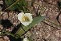 Subalpine Mariposa Lily Calochortus subalpinus
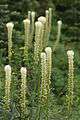 Bear Grass Xerophyllum tenax
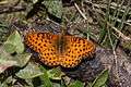 Coronis Fritillary Speyeria coronis
Sources
- Pyle, Robert Michael, "Where Bigfoot Walks: Crossing the Dark Divide", Houghton Mifflin, 1995, ISBN 0-395-44114-5
- Washington’s Dark Divide Roadless Area
| Wikimedia Commons has media related to Dark Divide. |
Coordinates: 46°19′06″N 121°45′39″W / 46.31833°N 121.76083°W