Dark Lake (Independence Township, Michigan)
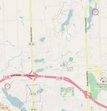
Partial map of Independence Township, with each Dark Lake circled
| Dark Lake, near Deer Lake | |
|---|---|
 | |
| Location | Oakland County, Michigan |
| Coordinates | 42°44′27″N 83°26′14″W / 42.7408627°N 83.4371642°W |
| Surface area | 5 acres (2.0 ha) |
| Max. depth | 10 ft (3.0 m) |
| Surface elevation | 968 ft (295 m) |
| Settlements | Independence Township |
| References | [1] |
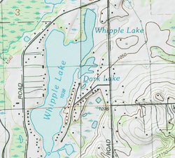
| Dark Lake, near Whipple Lake | |
|---|---|
 | |
| Location | Oakland County, Michigan |
| Coordinates | 42°46′50″N 83°22′27″W / 42.7805852°N 83.3741084°W |
| Surface area | 7 acres (2.8 ha) |
| Max. depth | 12 ft (3.7 m) |
| Surface elevation | 1,030 ft (310 m) |
| Settlements | Independence Township |
| References | [2] |
Dark Lake is the name given to two separate lakes within Independence Township in Oakland County, Michigan. The lakes lie approximately 4.5 miles (7.2 km) apart.
One lake covers 5 acres (2.0 ha), with a depth of 10 feet (3.0 m). It connects to Deer Lake on its north side.[1]
The other lake covers 7 acres (2.8 ha), with a depth of 12 feet (3.7 m). It connects to Whipple Lake on its east side.[2]
References
- 1 2 "Dark Lake Topo Map, Oakland County MI (Clarkston Area)". TopoZone. Retrieved 13 September 2016.
- 1 2 "Dark Lake Topo Map, Oakland County MI (Oxford Area)". TopoZone. Retrieved 13 September 2016.
External links
- U.S. Geological Survey Geographic Names Information System: Dark Lake near Deer Lake
- U.S. Geological Survey Geographic Names Information System: Dark Lake near Whipple Lake
This article is issued from Wikipedia - version of the 9/13/2016. The text is available under the Creative Commons Attribution/Share Alike but additional terms may apply for the media files.