Delitzsch
| Delitzsch | ||
|---|---|---|
|
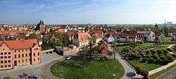
View over old town | ||
| ||
 Delitzsch | ||
Location of Delitzsch within Nordsachsen district  | ||
| Coordinates: 51°31′35″N 12°20′33″E / 51.52639°N 12.34250°ECoordinates: 51°31′35″N 12°20′33″E / 51.52639°N 12.34250°E | ||
| Country | Germany | |
| State | Saxony | |
| District | Nordsachsen | |
| Government | ||
| • Mayor | Dr. Manfred Wilde (Ind.) | |
| Area | ||
| • Total | 83.57 km2 (32.27 sq mi) | |
| Population (2015-12-31)[1] | ||
| • Total | 24,850 | |
| • Density | 300/km2 (770/sq mi) | |
| Time zone | CET/CEST (UTC+1/+2) | |
| Postal codes | 04509 | |
| Dialling codes | 034202 | |
| Vehicle registration | TDO, DZ, EB, OZ, TG, TO | |
| Website | www.delitzsch.de | |

Delitzsch (German pronunciation: [ˈdeːlɪtʃ], Slavic: delč or delčz for hill) is a town in the Free State of Saxony in Germany. With more than 26,000 inhabitants, it is the largest town in the district of Nordsachsen.
Archaeological evidence outside the town limits points to a settlement dating from the Neolithic Age. The first documented mention of Delitzsch dates from 1166 and it later became the elector's residence in the 17th and 18th centuries. The old town is well preserved, with several plazas, citizens' and patrician houses, towers, a baroque castle and the town's fortifications.
Delitzsch and its surrounding area contain water areas, hiking and cycling networks and nature reserves.
Geography
Location
Delitzsch is located in the northwestern part of Nordsachsen in Saxony, at an altitude of 94 meters above sea level. Due to its location on the border with Saxony-Anhalt, Delitzsch is the northernmost town in Saxony. It is situated on the north heath and recreation area Goitzsche which extends across the Saxony-Saxony-Anhalt border to Bitterfeld-Wolfen. To the east is the spa town of Bad Düben, which is the starting point for the Düben Heath.
The total size of the urban area is 83.57 square kilometres (32.27 square miles). The north-south extension is 10 kilometres (6 miles) and the east-west extension 8.3 kilometres (5.2 miles). The border communities are Löbnitz, Schönwölkau, Rackwitz and Neukyhna clockwise called from the north of town.
The graphic below shows the main towns and cities around Delitzsch and their distance from downtown Delitzsch. They are located in the districts Nordsachsen, Anhalt-Bitterfeld or in the cities of Leipzig and Halle on the Saale.
| Brehna 12km |
Bitterfeld-Wolfen 15km |
Bad Düben 22km | |
| Halle (Saale) 34 km (21 mi) |
|
Laußig 28km | |
| |||
| | |||
| Schkeuditz 25km |
Leipzig 23km |
Eilenburg 24km |
Districts
| Name of the District | Area in km² |
Population at September 2011 (Main domicile)[2] |
Density inhabitants/km² |
|---|---|---|---|
| Delitzsch with Gertitz, Kertitz and Werben |
38.04 | 20,974 | 551 |
| Beerendorf | 2.38 | 585 | 246 |
| Benndorf | 3.62 | 382 | 106 |
| Brodau | 3.16 | 314 | 99 |
| Döbernitz | 1.17 | 833 | 712 |
| Laue | 5.22 | 203 | 39 |
| Poßdorf | 7.78 | 66 | 8 |
| Rödgen | 4.12 | 224 | 54 |
| Schenkenberg | 2.43 | 832 | 342 |
| Selben | 3.33 | 664 | 199 |
| Spröda | 6,42 | 287 | 45 |
| Storkwitz | 3.59 | 150 | 42 |
| Zschepen | 2.31 | 407 | 176 |
| Overall | 83.57 | 25,921 | 310 |
History
Delitzsch was founded as a town around 1200 AD (according to chronicles) and became recognized as a city in 1300 AD. Both before and after its founding, the city fought off many invaders: first the Slavic tribes who had lived there before the city was founded and then, later, in the Thirty Years' War (1618-1648), the Swedes. A legend arose from this final encounter with the Swedes, saying that when the Swedes reached the river Lober, the tower warden's daughter spied them and blew a trumpet, allowing the citizens of the town to get to safety and prepare, and as a result the invaders were defeated. Every year there is a historical fair (medieval style) to celebrate this victory over the Swedes and, during the fair, shopping centers are open on Sundays.
As a result of the Congress of Vienna in, Delitzsch was granted to Prussia from the Kingdom of Saxony. A district of Delitzsch was established for administrative purposes.
In World War II (1939 - 1945), only one building, the station, was burned, minimal damage in comparison with many other German urban centers.
According to a 1996 census, Delitzsch had more than 27,000 inhabitants.
Historical Population
1747 - 1999
(using town boundaries as at the time)
|
|
|
¹ Census
² Merging districts
Source: Statistisches Landesamt des Freistaates Sachsen[3]
2000 - present
(using town boundaries as at the time)
|
| Census 2011 (new basis of calculation)
| ||||||||||||||||||||||||||||||||||||||||||||||
¹ Merging districts
Source: Statistisches Landesamt des Freistaates Sachsen[4]
Politics
Town council
The town council consists of the lord mayor and the number prescribed by the local order of 30 town councillors. Every five years, the town council is chosen anew; the next election is in 2014. The constituting meeting of the new-elective advice always takes place in the conference hall of the city hall. The current makeup has been in place since the last local election (held on the 7th of June 2009, with an election turnout of 50.47%), and is constituted as follows:
| Party | percentage of votes 2009 | seats | percentage of votes 2004 | seats |
|---|---|---|---|---|
| CDU | 34.9 percent | 11 | 43,2 percent | 14 |
| SPD | 20.5 percent | 7 | 19,0 percent | 6 |
| FWG | 14.6 percent | 4 | 9,2 percent | 2 |
| FDP | 4.6 percent | 1 | 4,7 percent | 1 |
| The Left (PDS) |
18.9 percent | 6 | 23,9 percent | 7 |
| NPD | 3.8 percent | 1 | - | - |
Mayor
Historian Manfred Wilde won the mayoral election in 2008 with 60.2 percent of the votes cast.
Coat of Arms
The emblem of the town Delitzsch combines two different arms, the house of Wettin or tribal emblem and the County of the Mark Meissen. It shows two upright poles blue (Landsberger piles) that are in a golden box, and this split in three parts. In the middle of the main shield of the emblem can be seen in an inclined position as a means to shield Meissen black lion on a golden shield. The middle blade is tilted forward, and so the lion appears as upright as possible, or borders. He has two tail tuft, with their division begins in the middle of the tail, which should point to the Mark Meissen County. As an accessory, the coat of arms (1526 introduced) a fluttering ribbon bearing the inscription: "Secretum civium in delitzsch" (loosely translated: Privy Seal of Delitzsch).
Twinning
| City | State | Country | Year |
|---|---|---|---|
| Friedrichshafen | |
|
1990 |
| Monheim am Rhein | |
|
1990 |
| Ostrów Wielkopolski | |
|
2000 |
Traffic
Road
To the west of the town the national roads B183a and B184 intersect.
Rail transport
Delitzsch has an "upper station" with two platforms and a "lower station" with three tracks. Both stations are in the tariff zone 165 of the regional public transport network. Since December 2008 go to two stations in addition to the trains of Deutsche Bahn (DB) and trains of the Central German regional train (MRB). The trains of the MRB go on all routes in the hour just like the trains of the DB, but usually about 30 minutes at the lower station and 60 minutes added at the upper station. Delitzsch is accessible in regional transport, place the other connections in Leipzig and Halle.
- The trains of the MRB take the following route:
- Eilenburg - Delitzsch upper station - Halle (Saale) Hauptbahnhof (MRB118)
- The DB trains run on the line:
- Eilenburg - Delitzsch upper station - Halle (Saale) Hauptbahnhof (RB118)
- Leipzig Hauptbahnhof - Delitzsch lower station - Bitterfeld - Dessau - Magdeburg (RE13)
- Leipzig Hauptbahnhof - Delitzsch lower station - Bitterfeld - Dessau (RB54)
- Leipzig Hauptbahnhof - Delitzsch lower station - Bitterfeld - Wittenberg (RB57)
- The trains of the S-Bahn Mitteldeutschland take the route:
- Gaschwitz - Leipzig-Connewitz - Leipzig City Tunnel - Delitzsch lower station - Bitterfeld (S2)
Air traffic
Leipzig/Halle Airport is located 14 miles (23 km) southwest of Delitzsch.
Local businesses
The most important industries in Delitzsch included the sugar and confectionery industry. Currently, the Delitzscher Chocolate Factory (acquired on 1 October 2008 by the Halloren Chocolate Factory AG), the EuroMaint Rail GmbH (former rail car plant SFW Delitzsch GmbH), URSA Insulation and the Smurfit Kappa Corrugated board plant are the major industrial employers. Most of these big companies are located in the industrial area on the south-west side.
Due to the EU production quotas for sugar, the sugar factory (Südzucker) was shut down in 2001.
Lignite mining was discontinued in the early 1990s, the remaining mines are planned to be a system of lakes and heathland in an arc from the southwest to the north.
Sights
- Baroque Castle Delitzsch with Lustgarten, former widow of travel and residence of the Dukes of Saxony-Merseburg
- Kennel gardens, terraced green space created between the city wall and moat (since 2010 re-opened)
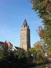
- Weir made from the 14th and 15th century city with two towers, the defensive wall, the water-filled moat
- Rose Garden
- City Church of St. Peter & Paul, brick church of the 15th century with significant high altar
- Schulze-Delitzsch-memorial to Hermann Schulze
- Executioner house in which lived since 1619 in charge of the executioner Delitzsch
- Writers House, former home and the workplace of the town clerk, now a gallery
- City Park in recovery wells
- Zoo Delitzsch
Sports
Among the many sports clubs in North Saxony district town, among other things, the annual sporting events like the LVZ Bicycle Ride, Delitzsch moves or the old town race. More than 13 sports clubs are based in the region of Delitzsch. Some of the clubs:
- 1. SV Concordia Delitzsch
- NHV Concordia Delitzsch 2010 e.V. (second handball club)
- GSVE Delitzsch 1995 e.V. (volleyball club)
- Delitzscher Sportfüchse 1995 e.V. (judo club)
- 1.FC Delitzsch 2010 e.V. (football club)
- RV Germania Delitzsch 1891 e.V. (bicycle club)
- Korean Tigers 1989 e.V. (Taekwondoverein)
- Delitzscher tennis club 1921 e.V.
- Badminton club Delitzsch
- Dive club Delitzsch 1958 e.v.
Education
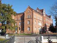
The first school was built around 1426 as a boys school and was expanded in the 16th century to cater for girls. Today more than 3,500 students learn in ten public and three private schools. These include three primary schools, two Mittelschulen (secondary schools), one grammar school, two colleges and two special schools. The School of Music, the Adult high school and the acting school are private schools.
- Primary schools
- Primary school Diesterweg
- Primary school on Rosenweg
- Primary school Delitzsch-East
- Middle schools
- Artur Becker- Middle School
- Middle School Delitzsch-North
- Grammar school
- Christian-Gottfried-Ehrenberg-Grammar School
- Technical and vocational schools
- School of Social Sciences
- Vocational School Dr. Hermann Schulze-Delitzsch
- Special schools
- Special Educationscool Rödgen - school for mentally disabled
- Pestalozzischool – school to promote learning
- Other schools
- Delitzsch Music School
- Theatre Academy Saxony (Acting School)
- Adult high school
Famous Delitzschers
- Christian Gottfried Ehrenberg (1795-1876), bioscientist who co-discovered the use of bacteria in medicine
- Lucas Brandis (c. 1450-1500) and his brothers, Moritz, Mark, and Matthew Brandis († after 1512), important early book printers
- Erasmus Schmidt (1570-1637), mathematician and philologist.
- Christian Saalbach (1653-1713), professor and poet, born in the district Schenkenberg
- Ernst Friedrich Pfotenhauer (1771-1843), jurist
- Carl August Ehrenberg (1801-1849), botanist and plant collector
- Hermann Schulze-Delitzsch (1808-1883), founder of the German cooperative system and politician, was born in the house market 11 (plaque). In 1848 as Prussian delegate he added the city name to his to be better distinguished from other delegates by this name.
- Clementine Helm (1825-1896), children's and youth book author
- Bernhard Förster (1843-1889), high school teacher, cultural critic and husband of Elizabeth (Forester) Nietzsche
- Paul Fürbringer (1849-1930), physician
- Walter Tiemann (1876-1951), book artist and graphic designer
- Max Bruning (1887-1968), painter, born in the house market 20
- Erich Bauer (1890-1970), student historians
- Anna Zammert (1898-1982), German politician and Gewerkschaftsfunktionärin
- Helmut Schreyer (1912-1984), German telecommunications specialist, inventor and professor at the Technical College of the Brazilian army in Rio de Janeiro
- Eberhard Ruhmer (1917-1996), art historian and curator, son of the city minister Wilhelm Ruhmer
- Joachim Fritsche (born 1951), football player in the East German league and played from 1973 to 1977 in the GDR national team
- Lutz Mack (born 1952), gymnast
- Siegfried Mehnert (born 1963), boxer
- Katrin Huss (born 1969), moderator
External links
![]() Media related to Delitzsch at Wikimedia Commons
Media related to Delitzsch at Wikimedia Commons
References
- ↑ "Aktuelle Einwohnerzahlen nach Gemeinden 2015] (Einwohnerzahlen auf Grundlage des Zensus 2011)" (PDF). Statistisches Landesamt des Freistaates Sachsen (in German). July 2016.
- ↑ Registration office of the town of Delitzsch
- ↑ Statistisches Landesamt des Freistaates Sachsen: Regionalregister Sachsen: Delitzsch
- ↑ Statistisches Landesamt des Freistaates Sachsen: Regionalregister Sachsen: Delitzsch
Towns and municipalities in Nordsachsen district | ||
|---|---|---|