Deriba Caldera
| Jebel Marra | |
|---|---|
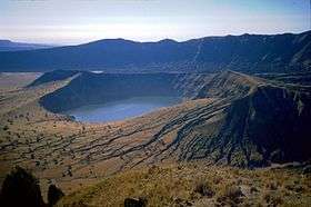 The inner and outer craters, Deriba Crater | |
| Highest point | |
| Elevation | 3,042 m (9,980 ft) |
| Prominence | 2,512 m (8,241 ft) |
| Listing |
Country high point Ultra |
| Coordinates | 12°57′5″N 24°15′32″E / 12.95139°N 24.25889°ECoordinates: 12°57′5″N 24°15′32″E / 12.95139°N 24.25889°E |
| Geography | |
 Jebel Marra Location in Sudan | |
| Location | Darfur, Sudan |
| Parent range | Marrah Mountains |
| Geology | |
| Mountain type | Caldera |
Deriba Caldera is at the highest point of Jebel Marra at an elevation of 3,042 m (9,980 ft), in Darfur in the western part of Sudan. The caldera rim became Sudan's new highest point, after the independence of South Sudan. It is between 5 km and 8 km in diameter across the outer crater. The inner crater is filled by a crater lake.
The Marra Mountains are part of a large geologic feature known as the Darfur Dome. The dome appears to be the result of a mantle plume, which is a fixed “hotspot” in the Earth’s mantle (the layer of Earth below the crust). The mantle plume heated the crust from below, leading to uplift of the crust and providing a magma source for the extensive volcanism observed in the region. The 5-kilometer-wide Deriba Caldera was formed by explosive eruption of the Jebel Marra Volcano approximately 3,500 years ago. The volcano is considered dormant, rather than extinct, as hot springs and fumaroles (gas and steam vents) are still present.
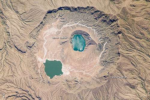
The caldera has the classic circular shape: the depression formed as overlying rock and soil collapsed into the magma chamber after it was emptied by powerful eruptions. Following the formation of the main outer crater, a second inner crater (image center) formed, most likely due to later uplift and eruption of fresh magma moving towards the surface. This inner crater is filled with water.
Because the walls of the inner crater are higher than the adjacent caldera floor, precipitation flowing inwards from the outer crater walls does not enter the inner crater lake. White stream bed sediments (image center) show the water pathway around the inner crater to a second lake located along the northeast wall of the outer crater. While Jebel Marra is high enough (3,042 meters) to have a temperate climate and high precipitation, these lakes may be fed by hot springs as well as rainwater.
References
![]() This article incorporates public domain material from the National Aeronautics and Space Administration document "Deriba Caldera, Sudan".
This article incorporates public domain material from the National Aeronautics and Space Administration document "Deriba Caldera, Sudan".
- Deriba Caldera, Sudan at NASA Earth Observatory. This article incorporates public domain text from this NASA webpage.
- The Jebel Marra, Darfur, and Its Region: J. H. G. Lebon, V. C. Robertson. The Geographical Journal, Vol. 127, No. 1 (Mar., 1961), pp. 30–45
- Notes on Jebel Marra, Darfur: H. F. C. Hobbs. The Geographical Journal, Vol. 52, No. 6 (Dec., 1918), pp. 357–363
- Sources of Water in the North-Western Sudan: K. S. Sandford. The Geographical Journal, Vol. 85, No. 5 (May, 1935), pp. 412–431
- Abstract :
- Tephra catalog of the world (about 26 lines down) :
- "Jebel Marra". Global Volcanism Program. Smithsonian Institution.
- Keeping planets cool: volcanoes, hotspots, and plate tectonics :
- Comparing Jebel Marra with a volcanoes on Mars (Alba Patera):
- (UNESCO) Fact-finding mission to Sudan, 8–20 May 2001: for an investigation of Sudan's Geothermal Resources, The Jebel Marra Area :
- The Culex mosquitos of the Sudan :
External links
- Location map (small scale) :
- Satellite image (large scale) :
- Oblique aerial photo on page 27 (large scale) :
- Deriba Caldera at NASA Earth Observatory